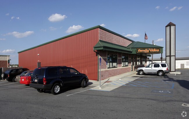
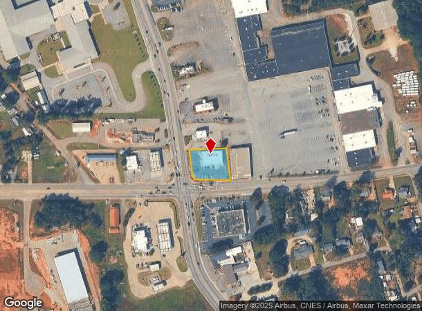
Property Record
302 Pearman Dairy Rd, Anderson, SC 29625
NEARBY LISTINGS FOR SALE OR LEASE
Property Detail
302 Pearman Dairy Rd
123-05-03-005
CP S 815/6+7 F120 D175 PP 082/942 HWY 28 + HWY 24 .58 AC
Storebuilding
Anderson
X
South Carolina
45007C0243E
0.58 AC
2025
Anderson Cy S of I-85
2024
Greenville/Spartanburg
000800
Greenville-Anderson-Mauldin, SC
5,298 SF
DEMOGRAPHICS near 302 Pearman Dairy Rd
1 Mile
3 Mile
5 Mile
2024 Total Population
3,788
35,965
74,581
2029 Population
4,082
38,783
80,029
Pop Growth 2024-2029
+ 7.76%
+ 7.84%
+ 7.30%
Average Age
40
40
40
2024 Total Households
1,648
14,786
30,318
HH Growth 2024-2029
+ 7.77%
+ 7.98%
+ 7.40%
Median Household Inc
$35,981
$39,551
$46,365
Avg Household Size
2.30
2.30
2.30
2024 Avg HH Vehicles
1.00
2.00
2.00
Median Home Value
$93,037
$128,922
$158,738
Median Year Built
1983
1975
1981
Nearby Places
Map Layers
Map Styles
 Street
 Aerial
- Restaurants
- Banks
- Shops
- Fitness
- Groceries
Nearby Properties
Address
Land Use
TOTAL SIZE
Lot Size
Zoning
Address
Land Use
TOTAL SIZE
Lot Size
Zoning
2,778 SF
12.37 AC
Address
Land Use
TOTAL SIZE
Lot Size
Zoning
2,027 SF
12.16 AC
Address
Land Use
TOTAL SIZE
Lot Size
Zoning
183,500 SF
19.79 AC
Address
Land Use
TOTAL SIZE
Lot Size
Zoning
1,210 SF
16.52 AC
Address
Land Use
TOTAL SIZE
Lot Size
Zoning
27,441 SF
5.49 AC
Address
Land Use
TOTAL SIZE
Lot Size
Zoning
121,232 SF
19.72 AC
Address
Land Use
TOTAL SIZE
Lot Size
Zoning
45,014 SF
0.29 AC
Address
Land Use
TOTAL SIZE
Lot Size
Zoning
1,983 SF
14.26 AC
Address
Land Use
TOTAL SIZE
Lot Size
Zoning
61,281 SF
0.74 AC
Address
Land Use
TOTAL SIZE
Lot Size
Zoning
75.85 AC
Address
Land Use
TOTAL SIZE
Lot Size
Zoning
9,550 SF
3 AC
Address
Land Use
TOTAL SIZE
Lot Size
Zoning
3,233 SF
9.93 AC
Address
Land Use
TOTAL SIZE
Lot Size
Zoning
71,500 SF
11.88 AC
Address
Land Use
TOTAL SIZE
Lot Size
Zoning
150,719 SF
31.62 AC
Address
Land Use
TOTAL SIZE
Lot Size
Zoning
0.74 AC
Address
Land Use
TOTAL SIZE
Lot Size
Zoning
30,250 SF
2 AC
Address
Land Use
TOTAL SIZE
Lot Size
Zoning
6,325 SF
4.84 AC
Address
Land Use
TOTAL SIZE
Lot Size
Zoning
9.51 AC
Address
Land Use
TOTAL SIZE
Lot Size
Zoning
24.87 AC
Address
Land Use
TOTAL SIZE
Lot Size
Zoning
9,406 SF
7.92 AC
Address
Land Use
TOTAL SIZE
Lot Size
Zoning
533,102 SF
66.26 AC
Address
Land Use
TOTAL SIZE
Lot Size
Zoning
14,693 SF
2.02 AC
Address
Land Use
TOTAL SIZE
Lot Size
Zoning
44,568 SF
2.47 AC
Address
Land Use
TOTAL SIZE
Lot Size
Zoning
135,705 SF
8.78 AC
Address
Land Use
TOTAL SIZE
Lot Size
Zoning
1,940 SF
5.70 AC
Address
Land Use
TOTAL SIZE
Lot Size
Zoning
94,335 SF
8.14 AC
Address
Land Use
TOTAL SIZE
Lot Size
Zoning
14,656 SF
1.93 AC
Address
Land Use
TOTAL SIZE
Lot Size
Zoning
40,036 SF
8.10 AC
Address
Land Use
TOTAL SIZE
Lot Size
Zoning
65,989 SF
6.46 AC
The World's #1 Commercial Real Estate Marketplace
Connect with us
© 2025 CoStar Group
The information above has been obtained from sources believed reliable. While we do not doubt its accuracy we have not verified it and make no guarantee, warranty or representation about it. It is your responsibility to independently confirm its accuracy and completeness. Any projections, opinions, assumptions, or estimates used are for example only and do not represent the current or future performance of the property. The value of this transaction to you depends on tax and other factors which should be evaluated by your tax, financial, and legal advisors. You and your advisors should conduct a careful, independent investigation of the property to determine to your satisfaction the suitability of the property for your needs.