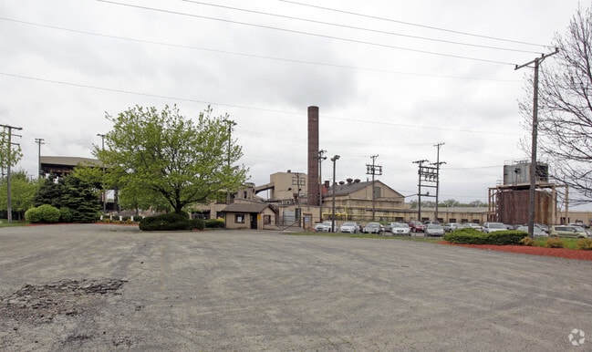
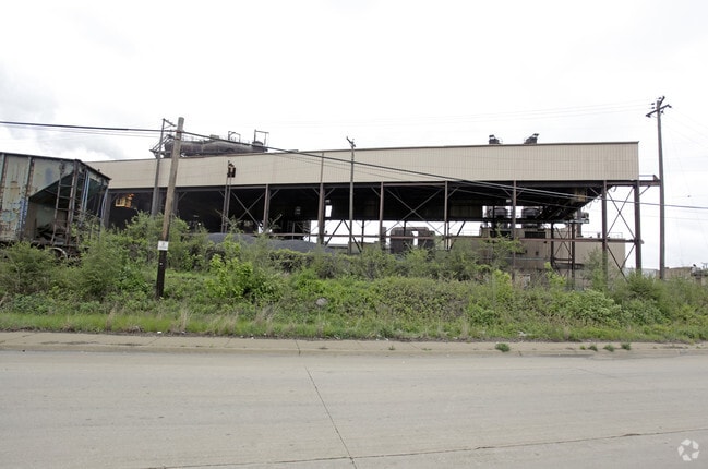
Property Record
302 Peoples Ave, Rockford, IL 61104

NEARBY LISTINGS FOR SALE OR LEASE
Property Detail
302 Peoples Ave
Rockford, IL
Rkfd Sand & Gravel Co Sub
11-35-302-011
RKFD SAND & GRAVEL CO SUB OF PT SEC 34& 35-44-1 BEG AT A PT ON WLY LN CB&QR/R 533 FT S OF N LN SW1/4 SEC
Industrialgeneral
Winnebago
X
Illinois
17201C0377E
44
2024
30.10 AC
2024
I-39 Cor/Winnebago Cy
002100
Chicago
604,385 SF
DEMOGRAPHICS near 302 Peoples Ave
1 Mile
3 Mile
5 Mile
2024 Total Population
6,834
69,166
140,725
2029 Population
6,738
68,874
139,578
Pop Growth 2024-2029
(1.40%)
(0.42%)
(0.82%)
Average Age
35
37
38
2024 Total Households
2,602
27,234
56,425
HH Growth 2024-2029
(1.38%)
(0.50%)
(0.86%)
Median Household Inc
$28,911
$36,058
$43,468
Avg Household Size
2.50
2.40
2.40
2024 Avg HH Vehicles
1.00
1.00
2.00
Median Home Value
$59,492
$72,522
$94,662
Median Year Built
1949
1952
1958
Nearby Places
Map Layers
Map Styles
 Street
 Aerial
- Restaurants
- Banks
- Shops
- Fitness
- Groceries
PUBLIC TRANSPORTATION
AIRPORT
Chicago/Rockford International
DRIVE
WALK
Distance
Chicago/Rockford International
16 min
7.1 mi
Freight Ports
Port Milwaukee
DRIVE
WALK
Distance
Port Milwaukee
117 min
95.2 mi
Nearby Properties
Address
Land Use
TOTAL SIZE
Lot Size
Zoning
Address
Land Use
TOTAL SIZE
Lot Size
Zoning
1,456,216 SF
103.10 AC
I1
Address
Land Use
TOTAL SIZE
Lot Size
Zoning
555,920 SF
37.99 AC
I2
Address
Land Use
TOTAL SIZE
Lot Size
Zoning
201,507 SF
C4
Address
Land Use
TOTAL SIZE
Lot Size
Zoning
13,308 SF
19.30 AC
I2
Address
Land Use
TOTAL SIZE
Lot Size
Zoning
291,074 SF
10.97 AC
I3
Address
Land Use
TOTAL SIZE
Lot Size
Zoning
189,455 SF
10.99 AC
I3
Address
Land Use
TOTAL SIZE
Lot Size
Zoning
115,095 SF
0.25 AC
C4
Address
Land Use
TOTAL SIZE
Lot Size
Zoning
117,360 SF
1.52 AC
R4
Address
Land Use
TOTAL SIZE
Lot Size
Zoning
111,491 SF
0.32 AC
C4
Address
Land Use
TOTAL SIZE
Lot Size
Zoning
173,193 SF
5.97 AC
I3
Address
Land Use
TOTAL SIZE
Lot Size
Zoning
79,318 SF
1.55 AC
C4
Address
Land Use
TOTAL SIZE
Lot Size
Zoning
43.23 AC
I1
Address
Land Use
TOTAL SIZE
Lot Size
Zoning
192,575 SF
46.19 AC
I1
Address
Land Use
TOTAL SIZE
Lot Size
Zoning
623,379 SF
35.15 AC
I3
Address
Land Use
TOTAL SIZE
Lot Size
Zoning
189,568 SF
12.68 AC
I1
Address
Land Use
TOTAL SIZE
Lot Size
Zoning
58,750 SF
11.25 AC
I1
Address
Land Use
TOTAL SIZE
Lot Size
Zoning
174,318 SF
17.97 AC
Address
Land Use
TOTAL SIZE
Lot Size
Zoning
2,975 SF
5.42 AC
I2
Address
Land Use
TOTAL SIZE
Lot Size
Zoning
212,574 SF
9.57 AC
I3
Address
Land Use
TOTAL SIZE
Lot Size
Zoning
108,233 SF
0.34 AC
C4
Address
Land Use
TOTAL SIZE
Lot Size
Zoning
158,754 SF
0.91 AC
C4
Address
Land Use
TOTAL SIZE
Lot Size
Zoning
39,184 SF
3.10 AC
C2
Address
Land Use
TOTAL SIZE
Lot Size
Zoning
150,351 SF
22.95 AC
I3
Address
Land Use
TOTAL SIZE
Lot Size
Zoning
77,936 SF
1.71 AC
C4
Address
Land Use
TOTAL SIZE
Lot Size
Zoning
10,970 SF
26.80 AC
R2
Address
Land Use
TOTAL SIZE
Lot Size
Zoning
151,360 SF
8.13 AC
I1
Address
Land Use
TOTAL SIZE
Lot Size
Zoning
584,794 SF
34.40 AC
I3
Address
Land Use
TOTAL SIZE
Lot Size
Zoning
239,792 SF
0.25 AC
C4
Address
Land Use
TOTAL SIZE
Lot Size
Zoning
85,575 SF
10.29 AC
C2
Address
Land Use
TOTAL SIZE
Lot Size
Zoning
299,238 SF
18.84 AC
I2
The World's #1 Commercial Real Estate Marketplace
Connect with us
© 2025 CoStar Group
The information above has been obtained from sources believed reliable. While we do not doubt its accuracy we have not verified it and make no guarantee, warranty or representation about it. It is your responsibility to independently confirm its accuracy and completeness. Any projections, opinions, assumptions, or estimates used are for example only and do not represent the current or future performance of the property. The value of this transaction to you depends on tax and other factors which should be evaluated by your tax, financial, and legal advisors. You and your advisors should conduct a careful, independent investigation of the property to determine to your satisfaction the suitability of the property for your needs.