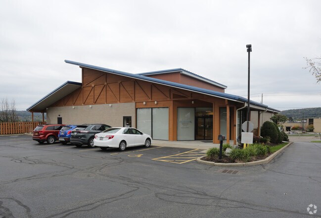
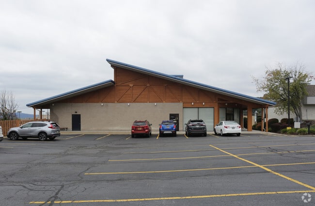
Property Record
302 Reynolds Rd, Johnson City, NY 13790
NEARBY LISTINGS FOR SALE OR LEASE
Property Detail
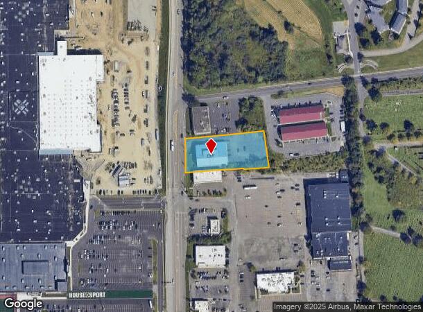
302 Reynolds Rd
Syracuse
Boundary Survey For B&F Development
Binghamton, NY
COM 001F120013S4X0000000
034603-143-005-0001-023-000-0000
Broome
Communitycenter
New York
2025
23.000
2024
1.10 AC
014200
Broome County
10,543 SF
DEMOGRAPHICS near 302 Reynolds Rd
1 Mile
3 Mile
5 Mile
2024 Total Population
5,659
45,230
118,208
2029 Population
5,544
44,429
115,785
Pop Growth 2024-2029
(2.03%)
(1.77%)
(2.05%)
Average Age
45
42
40
2024 Total Households
2,522
19,565
47,937
HH Growth 2024-2029
(2.22%)
(1.94%)
(2.30%)
Median Household Inc
$56,099
$50,629
$50,022
Avg Household Size
2.10
2.20
2.20
2024 Avg HH Vehicles
2.00
1.00
1.00
Median Home Value
$115,217
$136,222
$140,616
Median Year Built
1955
1954
1955
Nearby Places
- Restaurants
- Banks
- Shops
- Fitness
- Groceries
SALE & LEASE HISTORY
LISTING DATE
SALE/LEASE

Sep 25, 2016
For Lease
Nearby Properties
Address
Land Use
TOTAL SIZE
Lot Size
Zoning
Address
Land Use
TOTAL SIZE
Lot Size
Zoning
65,256 SF
579.06 AC
Address
Land Use
TOTAL SIZE
Lot Size
Zoning
9,790 SF
11.23 AC
ID
Address
Land Use
TOTAL SIZE
Lot Size
Zoning
88,796 SF
20.04 AC
Address
Land Use
TOTAL SIZE
Lot Size
Zoning
30,334 SF
238.95 AC
Address
Land Use
TOTAL SIZE
Lot Size
Zoning
203,306 SF
30.33 AC
C-2
Address
Land Use
TOTAL SIZE
Lot Size
Zoning
87,453 SF
6.77 AC
C-2
Address
Land Use
TOTAL SIZE
Lot Size
Zoning
68,845 SF
4.74 AC
C-2
Address
Land Use
TOTAL SIZE
Lot Size
Zoning
124,053 SF
7.63 AC
RC
Address
Land Use
TOTAL SIZE
Lot Size
Zoning
0.98 AC
RR
Address
Land Use
TOTAL SIZE
Lot Size
Zoning
117,267 SF
17.65 AC
C-2
Address
Land Use
TOTAL SIZE
Lot Size
Zoning
203,296 SF
3.73 AC
Address
Land Use
TOTAL SIZE
Lot Size
Zoning
126,000 SF
10.76 AC
C-2
Address
Land Use
TOTAL SIZE
Lot Size
Zoning
139,175 SF
13.43 AC
C-2
Address
Land Use
TOTAL SIZE
Lot Size
Zoning
135,382 SF
14.47 AC
Address
Land Use
TOTAL SIZE
Lot Size
Zoning
184,243 SF
11.46 AC
Address
Land Use
TOTAL SIZE
Lot Size
Zoning
0.53 AC
RR
Address
Land Use
TOTAL SIZE
Lot Size
Zoning
97,204 SF
1.45 AC
C-1
Address
Land Use
TOTAL SIZE
Lot Size
Zoning
87,842 SF
7.73 AC
C-2
Address
Land Use
TOTAL SIZE
Lot Size
Zoning
34,606 SF
4.10 AC
Address
Land Use
TOTAL SIZE
Lot Size
Zoning
97,087 SF
1.66 AC
C-2
Address
Land Use
TOTAL SIZE
Lot Size
Zoning
18,104 SF
9.94 AC
RC
Address
Land Use
TOTAL SIZE
Lot Size
Zoning
95,892 SF
1.18 AC
CD
Address
Land Use
TOTAL SIZE
Lot Size
Zoning
69,983 SF
10.29 AC
C-2
Address
Land Use
TOTAL SIZE
Lot Size
Zoning
24,000 SF
12.77 AC
C-2
Address
Land Use
TOTAL SIZE
Lot Size
Zoning
95,842 SF
16.33 AC
I
Address
Land Use
TOTAL SIZE
Lot Size
Zoning
24,600 SF
8.75 AC
RC
Address
Land Use
TOTAL SIZE
Lot Size
Zoning
33,600 SF
7.16 AC
RC
Address
Land Use
TOTAL SIZE
Lot Size
Zoning
58,604 SF
6.02 AC
I
Address
Land Use
TOTAL SIZE
Lot Size
Zoning
12,665 SF
2.65 AC
C-1
Address
Land Use
TOTAL SIZE
Lot Size
Zoning
74,394 SF
7.51 AC
C-2
The World's #1 Commercial Real Estate Marketplace
Connect with us
© 2025 CoStar Group
The information above has been obtained from sources believed reliable. While we do not doubt its accuracy we have not verified it and make no guarantee, warranty or representation about it. It is your responsibility to independently confirm its accuracy and completeness. Any projections, opinions, assumptions, or estimates used are for example only and do not represent the current or future performance of the property. The value of this transaction to you depends on tax and other factors which should be evaluated by your tax, financial, and legal advisors. You and your advisors should conduct a careful, independent investigation of the property to determine to your satisfaction the suitability of the property for your needs.