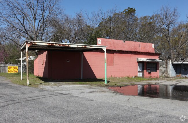
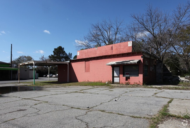
Property Record
302 S Armed Forces Blvd, Warner Robins, GA 31088
Save to a Folder
{{folder.Name}}
{{folder.ListingIds.length}} Properties
{{folder.ListingIds.length}} Property
Create a New Folder
Property Detail
302 S Armed Forces Blvd
Warner Robins, GA
LOT 1 BLK 3 WELLSTON ADDITION 225/5TH
0W003A005000
HOUSTON
Commercialacreage
Georgia
C2
1
B and X Area of moderate flood hazard, usually the area between the limits of the 100-year and 500-year floods.
0.11 AC
2025
Perry/Warner Robins
2025
Other Market Areas
020400
NEARBY LISTINGS FOR SALE OR LEASE
DEMOGRAPHICS near 302 S Armed Forces Blvd
1 mile
3 mile
5 mile
2025 Total Population
3,636
36,079
77,058
2030 Population
3,909
38,125
81,218
Pop Growth 2025-2030
+ 7.51%
+ 5.67%
+ 5.40%
Average Age
34
37
38
2025 Total Households
1,328
14,043
30,617
HH Growth 2025-2030
+ 7.83%
+ 5.73%
+ 5.45%
Median Household Inc
$48,022
$49,358
$60,846
Avg Household Size
2.60
2.40
2.40
2025 Avg HH Vehicles
2.00
2.00
2.00
Median Home Value
$76,369
$129,183
$167,989
Median Year Built
1982
1973
1982
Nearby Places
Map Layers
Map Styles
 Street
 Aerial
Layers
 Traffic
 Biking
Places
Listings with unknown addresses are not visible on the map
- Restaurants
- Banks
- Shops
- Fitness
- Groceries
Nearby Properties
Address
Land Use
TOTAL SIZE
Lot Size
Zoning
Address
Land Use
TOTAL SIZE
Lot Size
Zoning
3,199 SF
41.42 AC
R4
Address
Land Use
TOTAL SIZE
Lot Size
Zoning
88,965 SF
18.72 AC
R2
Address
Land Use
TOTAL SIZE
Lot Size
Zoning
11,658 SF
30.23 AC
R2
Address
Land Use
TOTAL SIZE
Lot Size
Zoning
100,320 SF
26.91 AC
C2
Address
Land Use
TOTAL SIZE
Lot Size
Zoning
218,304 SF
47.18 AC
C2
Address
Land Use
TOTAL SIZE
Lot Size
Zoning
304,246 SF
23.11 AC
C2
Address
Land Use
TOTAL SIZE
Lot Size
Zoning
855,853 SF
101.75 AC
M2
Address
Land Use
TOTAL SIZE
Lot Size
Zoning
164,700 SF
19.20 AC
R3
Address
Land Use
TOTAL SIZE
Lot Size
Zoning
178,400 SF
49.03 AC
R2
Address
Land Use
TOTAL SIZE
Lot Size
Zoning
1,531 SF
27.16 AC
R4
Address
Land Use
TOTAL SIZE
Lot Size
Zoning
14,096 SF
14.12 AC
R4
Address
Land Use
TOTAL SIZE
Lot Size
Zoning
22,112 SF
14.70 AC
R4
Address
Land Use
TOTAL SIZE
Lot Size
Zoning
26,928 SF
5.74 AC
R4
Address
Land Use
TOTAL SIZE
Lot Size
Zoning
91,692 SF
5.69 AC
R4
Address
Land Use
TOTAL SIZE
Lot Size
Zoning
40,284 SF
3.74 AC
C3
Address
Land Use
TOTAL SIZE
Lot Size
Zoning
71,578 SF
13.67 AC
C2
Address
Land Use
TOTAL SIZE
Lot Size
Zoning
25,062 SF
R4
Address
Land Use
TOTAL SIZE
Lot Size
Zoning
19,816 SF
13.60 AC
R4
Address
Land Use
TOTAL SIZE
Lot Size
Zoning
221,145 SF
28.22 AC
M2
Address
Land Use
TOTAL SIZE
Lot Size
Zoning
25,062 SF
R4
Address
Land Use
TOTAL SIZE
Lot Size
Zoning
3,906 SF
12.53 AC
C2
Address
Land Use
TOTAL SIZE
Lot Size
Zoning
61,628 SF
45 AC
C2
Address
Land Use
TOTAL SIZE
Lot Size
Zoning
95,030 SF
11.23 AC
C2
Address
Land Use
TOTAL SIZE
Lot Size
Zoning
94,798 SF
8.17 AC
R2
Address
Land Use
TOTAL SIZE
Lot Size
Zoning
11,200 SF
7.60 AC
R4
Address
Land Use
TOTAL SIZE
Lot Size
Zoning
3,375 SF
13.72 AC
R4
Address
Land Use
TOTAL SIZE
Lot Size
Zoning
5,220 SF
8.66 AC
C2
Address
Land Use
TOTAL SIZE
Lot Size
Zoning
1,512 SF
309.01 AC
M2
Address
Land Use
TOTAL SIZE
Lot Size
Zoning
71,434 SF
10.58 AC
R2
Address
Land Use
TOTAL SIZE
Lot Size
Zoning
1,448 SF
4.98 AC
R4
The World's #1 Commercial Real Estate Marketplace
Connect with us
© 2026 CoStar Group
The information above has been obtained from sources believed reliable. While we do not doubt its accuracy we have not verified it and make no guarantee, warranty or representation about it. It is your responsibility to independently confirm its accuracy and completeness. Any projections, opinions, assumptions, or estimates used are for example only and do not represent the current or future performance of the property. The value of this transaction to you depends on tax and other factors which should be evaluated by your tax, financial, and legal advisors. You and your advisors should conduct a careful, independent investigation of the property to determine to your satisfaction the suitability of the property for your needs.