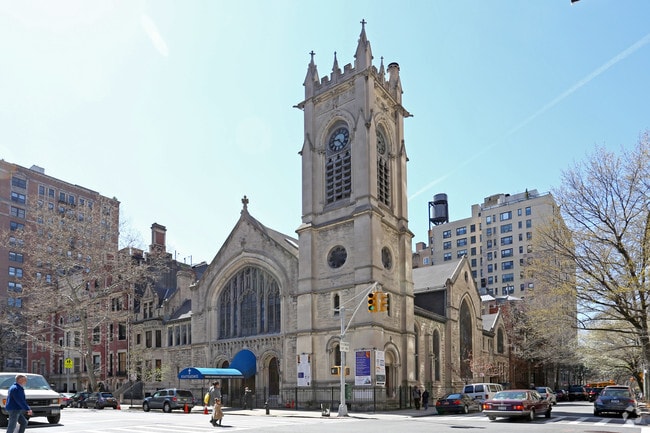
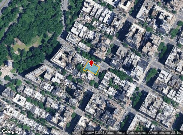
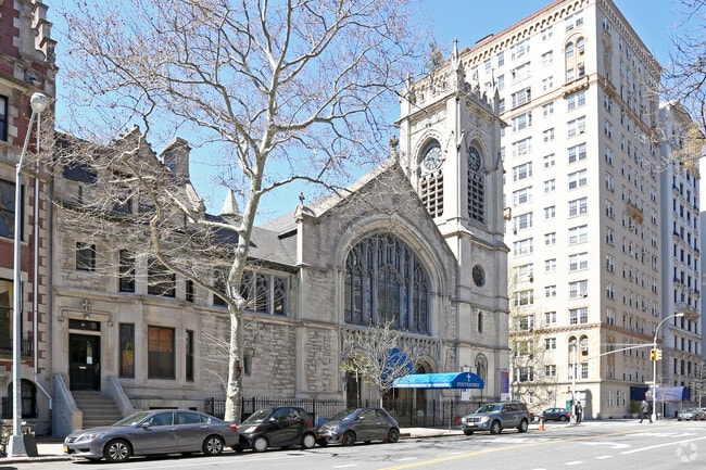
Property Record
633 W End Ave, New York, NY 10024
Current Lease Availabilities
NEARBY LISTINGS FOR SALE OR LEASE
Property Detail
633 W End Ave
1251-0022
Manhattan
Religious
New York
X
22
34003C0286H
0.24 AC
0
Upper West Side
2025
New York City
017900
New York-Jersey City-White Plains, NY-NJ
10,000 SF
DEMOGRAPHICS near 633 W End Ave
1 Mile
3 Mile
5 Mile
2024 Total Population
141,783
1,098,371
2,479,167
2029 Population
129,193
1,022,176
2,324,475
Pop Growth 2024-2029
(8.88%)
(6.94%)
(6.24%)
Average Age
45
42
40
2024 Total Households
69,367
513,735
1,104,933
HH Growth 2024-2029
(9.07%)
(7.20%)
(6.57%)
Median Household Inc
$112,951
$84,573
$78,697
Avg Household Size
1.90
2.00
2.10
2024 Avg HH Vehicles
.00
.00
.00
Median Home Value
$1,028,939
$895,995
$818,183
Median Year Built
1946
1958
1956
Nearby Places
- Restaurants
- Banks
- Shops
- Fitness
- Groceries
PUBLIC TRANSPORTATION
TRANSIT/SUBWAY
86 Street (1,2 Line) (1 - New York MTA Subway (The Subway), 2 - New York MTA Subway (The Subway))
DRIVE
WALK
Distance
86 Street (1,2 Line) (1 - New York MTA Subway (The Subway), 2 - New York MTA Subway (The Subway))
1 min
6 min
0.3 mi
96 Street (1,2,3 Line) (1 - New York MTA Subway (The Subway), 2 - New York MTA Subway (The Subway), 3 - New York MTA Subway (The Subway))
DRIVE
WALK
Distance
96 Street (1,2,3 Line) (1 - New York MTA Subway (The Subway), 2 - New York MTA Subway (The Subway), 3 - New York MTA Subway (The Subway))
1 min
6 min
0.4 mi
79 Street (1,2 Line) (1 - New York MTA Subway (The Subway), 2 - New York MTA Subway (The Subway))
DRIVE
WALK
Distance
79 Street (1,2 Line) (1 - New York MTA Subway (The Subway), 2 - New York MTA Subway (The Subway))
2 min
13 min
0.7 mi
86 Street (A,B,C Line) (A - New York MTA Subway (The Subway), B - New York MTA Subway (The Subway), C - New York MTA Subway (The Subway))
DRIVE
WALK
Distance
86 Street (A,B,C Line) (A - New York MTA Subway (The Subway), B - New York MTA Subway (The Subway), C - New York MTA Subway (The Subway))
3 min
13 min
0.7 mi
96 Street (A,B,C Line) (A - New York MTA Subway (The Subway), B - New York MTA Subway (The Subway), C - New York MTA Subway (The Subway))
DRIVE
WALK
Distance
96 Street (A,B,C Line) (A - New York MTA Subway (The Subway), B - New York MTA Subway (The Subway), C - New York MTA Subway (The Subway))
2 min
15 min
0.8 mi
COMMUTER RAIL
Harlem-125Th Street Station (Harlem Line - Metro-North Commuter Railroad Company (Metro-North), Hudson Line - Metro-North Commuter Railroad Company (Metro-North), New Haven Line - Metro-North Commuter Railroad Company (Metro-North))
DRIVE
WALK
Distance
Harlem-125Th Street Station (Harlem Line - Metro-North Commuter Railroad Company (Metro-North), Hudson Line - Metro-North Commuter Railroad Company (Metro-North), New Haven Line - Metro-North Commuter Railroad Company (Metro-North))
7 min
3.5 mi
Grand Central (Babylon Branch - Long Island Rail Road, Far Rockaway Branch - Long Island Rail Road, Hempstead Branch - Long Island Rail Road, Port Jefferson Branch - Long Island Rail Road, Port Washington Branch - Long Island Rail Road)
DRIVE
WALK
Distance
Grand Central (Babylon Branch - Long Island Rail Road, Far Rockaway Branch - Long Island Rail Road, Hempstead Branch - Long Island Rail Road, Port Jefferson Branch - Long Island Rail Road, Port Washington Branch - Long Island Rail Road)
8 min
3.5 mi
AIRPORT
LaGuardia
DRIVE
WALK
Distance
LaGuardia
20 min
9.3 mi
Newark Liberty International
DRIVE
WALK
Distance
Newark Liberty International
25 min
16.5 mi
John F Kennedy International
DRIVE
WALK
Distance
John F Kennedy International
33 min
20.5 mi
Freight Ports
NY - Red Hook Container Terminal
DRIVE
WALK
Distance
NY - Red Hook Container Terminal
25 min
10.0 mi
Nearby Properties
Address
Land Use
TOTAL SIZE
Lot Size
Zoning
Address
Land Use
TOTAL SIZE
Lot Size
Zoning
4,060,596 SF
22.09 AC
M2-3
Address
Land Use
TOTAL SIZE
Lot Size
Zoning
2,245,112 SF
2.02 AC
C6-6
Address
Land Use
TOTAL SIZE
Lot Size
Zoning
1,783,434 SF
1.94 AC
C5-3
Address
Land Use
TOTAL SIZE
Lot Size
Zoning
2,521,850 SF
1.59 AC
C6-4
Address
Land Use
TOTAL SIZE
Lot Size
Zoning
1,445,092 SF
3.10 AC
C6-4
Address
Land Use
TOTAL SIZE
Lot Size
Zoning
2,221,336 SF
1.55 AC
C6-4
Address
Land Use
TOTAL SIZE
Lot Size
Zoning
2,636,182 SF
2.35 AC
C65.5
Address
Land Use
TOTAL SIZE
Lot Size
Zoning
2,734,038 SF
4.24 AC
C52.5
Address
Land Use
TOTAL SIZE
Lot Size
Zoning
1,678,135 SF
1.01 AC
C5-3
Address
Land Use
TOTAL SIZE
Lot Size
Zoning
1,897,491 SF
2.06 AC
C52.5
Address
Land Use
TOTAL SIZE
Lot Size
Zoning
1,233,684 SF
16.94 AC
PARK
Address
Land Use
TOTAL SIZE
Lot Size
Zoning
1,638,259 SF
1.43 AC
C52.5
Address
Land Use
TOTAL SIZE
Lot Size
Zoning
2,360,627 SF
2.08 AC
C6-7
Address
Land Use
TOTAL SIZE
Lot Size
Zoning
1,642,675 SF
1.05 AC
C6-7
Address
Land Use
TOTAL SIZE
Lot Size
Zoning
1,984,228 SF
1.95 AC
C65.5
Address
Land Use
TOTAL SIZE
Lot Size
Zoning
1,586,876 SF
1.87 AC
C5-3
Address
Land Use
TOTAL SIZE
Lot Size
Zoning
1,962,900 SF
1.89 AC
C66.5
Address
Land Use
TOTAL SIZE
Lot Size
Zoning
1,946,157 SF
1.49 AC
C6-4
Address
Land Use
TOTAL SIZE
Lot Size
Zoning
1,842,991 SF
2.08 AC
C66.5
Address
Land Use
TOTAL SIZE
Lot Size
Zoning
2,535,958 SF
2.94 AC
C6-4
Address
Land Use
TOTAL SIZE
Lot Size
Zoning
1,178,640 SF
0.92 AC
C6-4
Address
Land Use
TOTAL SIZE
Lot Size
Zoning
400,160 SF
10.96 AC
R7-2
Address
Land Use
TOTAL SIZE
Lot Size
Zoning
1,613,847 SF
1.84 AC
C66.5
Address
Land Use
TOTAL SIZE
Lot Size
Zoning
2,215,000 SF
6.43 AC
R9
Address
Land Use
TOTAL SIZE
Lot Size
Zoning
1,596,521 SF
1.34 AC
C6-4
Address
Land Use
TOTAL SIZE
Lot Size
Zoning
2,344,406 SF
1.84 AC
C5-3
Address
Land Use
TOTAL SIZE
Lot Size
Zoning
1,805,894 SF
1.42 AC
C6-4
Address
Land Use
TOTAL SIZE
Lot Size
Zoning
264,420 SF
7.26 AC
C4-7
Address
Land Use
TOTAL SIZE
Lot Size
Zoning
431,963 SF
C67T
Address
Land Use
TOTAL SIZE
Lot Size
Zoning
1,448,897 SF
1.56 AC
C6-6
The World's #1 Commercial Real Estate Marketplace
Connect with us
© 2025 CoStar Group
The information above has been obtained from sources believed reliable. While we do not doubt its accuracy we have not verified it and make no guarantee, warranty or representation about it. It is your responsibility to independently confirm its accuracy and completeness. Any projections, opinions, assumptions, or estimates used are for example only and do not represent the current or future performance of the property. The value of this transaction to you depends on tax and other factors which should be evaluated by your tax, financial, and legal advisors. You and your advisors should conduct a careful, independent investigation of the property to determine to your satisfaction the suitability of the property for your needs.