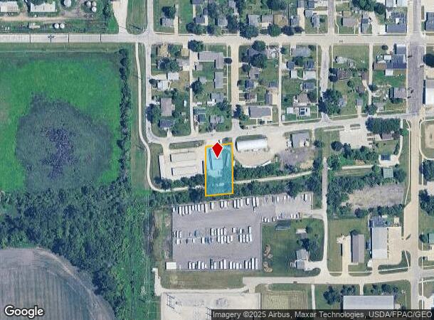
Property Record
302 W Railway St, Huxley, IA 50124

NEARBY LISTINGS FOR SALE OR LEASE
Property Detail
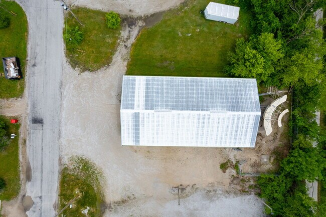
302 W Railway St
13-26-221-007
RAILROAD SD NO 2 E110' LOT 1
Warehouse
Story
X
Iowa
19169C0290F
1
2024
0.51 AC
2025
Fort Dodge/Ames
010101
Other Market Areas
3,200 SF
Ames, IA
DEMOGRAPHICS near 302 W Railway St
1 Mile
3 Mile
5 Mile
2024 Total Population
3,715
5,342
8,741
2029 Population
3,866
5,557
9,041
Pop Growth 2024-2029
+ 4.06%
+ 4.02%
+ 3.43%
Average Age
35
35
37
2024 Total Households
1,338
1,921
3,268
HH Growth 2024-2029
+ 4.26%
+ 4.22%
+ 3.58%
Median Household Inc
$117,416
$117,589
$106,502
Avg Household Size
2.80
2.80
2.70
2024 Avg HH Vehicles
2.00
2.00
2.00
Median Home Value
$286,699
$287,154
$259,533
Median Year Built
1991
1991
1978
Nearby Places
Map Layers
Map Styles
 Street
 Aerial
- Restaurants
- Banks
- Shops
- Fitness
- Groceries
PUBLIC TRANSPORTATION
AIRPORT
Des Moines International
DRIVE
WALK
Distance
Des Moines International
42 min
30.3 mi
SALE & LEASE HISTORY
LISTING DATE
SALE/LEASE

Jun 01, 2023
For Sale
Nearby Properties
Address
Land Use
TOTAL SIZE
Lot Size
Zoning
Address
Land Use
TOTAL SIZE
Lot Size
Zoning
40,000 SF
56.30 AC
A2
Address
Land Use
TOTAL SIZE
Lot Size
Zoning
88,050 SF
7.83 AC
Address
Land Use
TOTAL SIZE
Lot Size
Zoning
383 SF
3.44 AC
Address
Land Use
TOTAL SIZE
Lot Size
Zoning
4,233 SF
37.82 AC
A1
Address
Land Use
TOTAL SIZE
Lot Size
Zoning
36,805 SF
4.59 AC
Address
Land Use
TOTAL SIZE
Lot Size
Zoning
32,725 SF
2.35 AC
Address
Land Use
TOTAL SIZE
Lot Size
Zoning
3,500 SF
22.91 AC
Address
Land Use
TOTAL SIZE
Lot Size
Zoning
8,106 SF
5.41 AC
Address
Land Use
TOTAL SIZE
Lot Size
Zoning
15.37 AC
Address
Land Use
TOTAL SIZE
Lot Size
Zoning
4.68 AC
Address
Land Use
TOTAL SIZE
Lot Size
Zoning
63,735 SF
3.88 AC
Address
Land Use
TOTAL SIZE
Lot Size
Zoning
8,320 SF
3.17 AC
Address
Land Use
TOTAL SIZE
Lot Size
Zoning
56,220 SF
3.59 AC
Address
Land Use
TOTAL SIZE
Lot Size
Zoning
10.04 AC
Address
Land Use
TOTAL SIZE
Lot Size
Zoning
18,623 SF
2.96 AC
Address
Land Use
TOTAL SIZE
Lot Size
Zoning
4,244 SF
5 AC
Address
Land Use
TOTAL SIZE
Lot Size
Zoning
2,967 SF
3.15 AC
Address
Land Use
TOTAL SIZE
Lot Size
Zoning
12,500 SF
2.56 AC
Address
Land Use
TOTAL SIZE
Lot Size
Zoning
3,445 SF
1 AC
Address
Land Use
TOTAL SIZE
Lot Size
Zoning
22,772 SF
2.85 AC
Address
Land Use
TOTAL SIZE
Lot Size
Zoning
4,250 SF
75.32 AC
A-1, AGRIC
Address
Land Use
TOTAL SIZE
Lot Size
Zoning
Address
Land Use
TOTAL SIZE
Lot Size
Zoning
Address
Land Use
TOTAL SIZE
Lot Size
Zoning
3,600 SF
3.96 AC
Address
Land Use
TOTAL SIZE
Lot Size
Zoning
11,394 SF
1.53 AC
Address
Land Use
TOTAL SIZE
Lot Size
Zoning
20,500 SF
1.80 AC
Address
Land Use
TOTAL SIZE
Lot Size
Zoning
7,716 SF
2.20 AC
Address
Land Use
TOTAL SIZE
Lot Size
Zoning
3,825 SF
0.93 AC
Address
Land Use
TOTAL SIZE
Lot Size
Zoning
7,071 SF
2.02 AC
The World's #1 Commercial Real Estate Marketplace
Connect with us
© 2025 CoStar Group
The information above has been obtained from sources believed reliable. While we do not doubt its accuracy we have not verified it and make no guarantee, warranty or representation about it. It is your responsibility to independently confirm its accuracy and completeness. Any projections, opinions, assumptions, or estimates used are for example only and do not represent the current or future performance of the property. The value of this transaction to you depends on tax and other factors which should be evaluated by your tax, financial, and legal advisors. You and your advisors should conduct a careful, independent investigation of the property to determine to your satisfaction the suitability of the property for your needs.