Property Record
302 W Ray Fine Blvd, Muldrow, OK 74948


NEARBY LISTINGS FOR SALE OR LEASE
Property Detail
302 W Ray Fine Blvd
0000-26-011-026-0-059-00
PT NW NE COM @ NW/C S.00 05 57 E.127' FOR POB: S.89 40 42 E. 500', S.00 05 57 E. 1000', N.89 40 42 W.500', N.0 05 57 W. 1000'
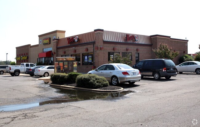
Truckstopfuelanddiner
Sequoyah
X
Oklahoma
40135C0469F
10 AC
2025
Sequoyah County
2025
Fort Smith
030403
Fort Smith, AR-OK
8,877 SF
DEMOGRAPHICS near 302 W Ray Fine Blvd
1 Mile
3 Mile
5 Mile
2024 Total Population
1,234
5,930
10,820
2029 Population
1,240
5,945
10,872
Pop Growth 2024-2029
+ 0.49%
+ 0.25%
+ 0.48%
Average Age
38
39
40
2024 Total Households
476
2,271
4,148
HH Growth 2024-2029
+ 0.42%
+ 0.22%
+ 0.43%
Median Household Inc
$41,797
$41,348
$41,672
Avg Household Size
2.60
2.60
2.60
2024 Avg HH Vehicles
2.00
2.00
2.00
Median Home Value
$111,832
$117,147
$117,073
Median Year Built
1983
1983
1983
Nearby Places
Map Layers
Map Styles
 Street
 Aerial
- Restaurants
- Banks
- Shops
- Fitness
- Groceries
PUBLIC TRANSPORTATION
AIRPORT
Fort Smith Regional
DRIVE
WALK
Distance
Fort Smith Regional
26 min
11.7 mi
Nearby Properties
Address
Land Use
TOTAL SIZE
Lot Size
Zoning
Address
Land Use
TOTAL SIZE
Lot Size
Zoning
4,427 SF
3.85 AC
Address
Land Use
TOTAL SIZE
Lot Size
Zoning
5,800 SF
4.05 AC
Address
Land Use
TOTAL SIZE
Lot Size
Zoning
2,580 SF
3.38 AC
Address
Land Use
TOTAL SIZE
Lot Size
Zoning
8,828 SF
1.91 AC
Address
Land Use
TOTAL SIZE
Lot Size
Zoning
11,520 SF
2.50 AC
Address
Land Use
TOTAL SIZE
Lot Size
Zoning
522 SF
2 AC
Address
Land Use
TOTAL SIZE
Lot Size
Zoning
3,122 SF
2 AC
Address
Land Use
TOTAL SIZE
Lot Size
Zoning
3,178 SF
1 AC
Address
Land Use
TOTAL SIZE
Lot Size
Zoning
198 SF
0.81 AC
Address
Land Use
TOTAL SIZE
Lot Size
Zoning
3,780 SF
3.56 AC
Address
Land Use
TOTAL SIZE
Lot Size
Zoning
3,000 SF
0.44 AC
Address
Land Use
TOTAL SIZE
Lot Size
Zoning
7,680 SF
0.25 AC
The World's #1 Commercial Real Estate Marketplace
Connect with us
© 2026 CoStar Group
The information above has been obtained from sources believed reliable. While we do not doubt its accuracy we have not verified it and make no guarantee, warranty or representation about it. It is your responsibility to independently confirm its accuracy and completeness. Any projections, opinions, assumptions, or estimates used are for example only and do not represent the current or future performance of the property. The value of this transaction to you depends on tax and other factors which should be evaluated by your tax, financial, and legal advisors. You and your advisors should conduct a careful, independent investigation of the property to determine to your satisfaction the suitability of the property for your needs.