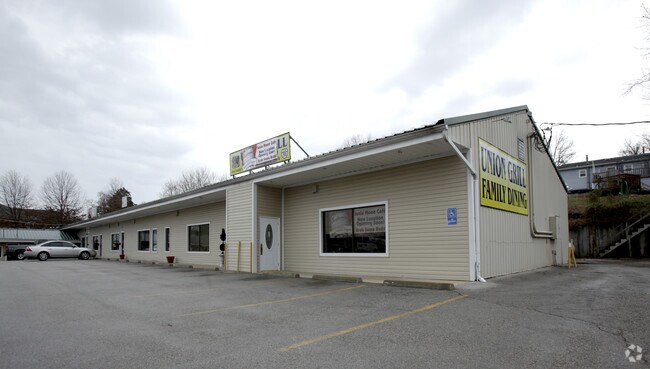
Property Record
302 W Us Highway 50 W, Union, MO 63084
NEARBY LISTINGS FOR SALE OR LEASE
Property Detail
302 W Us Highway 50 W
St. Louis, MO-IL
Highway
17-8-270-4-024-453000
THE COUNTY SEAT PLAZALOT 1, 2, & 3 HIGHWAY ADDN
Realpropertynec
Franklin
X
Missouri
29071C0285D
1-3
2025
0.90 AC
2025
Franklin County
800605
St. Louis
13,241 SF
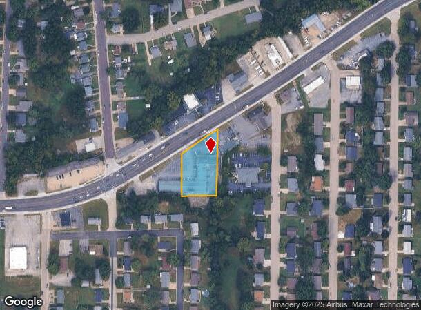
DEMOGRAPHICS near 302 W Us Highway 50 W
1 Mile
3 Mile
5 Mile
2024 Total Population
4,732
13,174
21,600
2029 Population
4,850
13,489
22,182
Pop Growth 2024-2029
+ 2.49%
+ 2.39%
+ 2.69%
Average Age
39
39
40
2024 Total Households
1,855
5,091
8,261
HH Growth 2024-2029
+ 2.48%
+ 2.32%
+ 2.64%
Median Household Inc
$62,157
$67,318
$71,556
Avg Household Size
2.50
2.50
2.50
2024 Avg HH Vehicles
2.00
2.00
2.00
Median Home Value
$155,993
$181,891
$208,224
Median Year Built
1981
1993
1993
Nearby Places
Map Layers
Map Styles
 Street
 Aerial
- Restaurants
- Banks
- Shops
- Fitness
- Groceries
PUBLIC TRANSPORTATION
COMMUTER RAIL
Washington Amtrak Station (Lincoln Service Missouri River Runner - Amtrak, Missouri River Runner - Amtrak)
DRIVE
WALK
Distance
Washington Amtrak Station (Lincoln Service Missouri River Runner - Amtrak, Missouri River Runner - Amtrak)
17 min
9.4 mi
Freight Ports
Tulsa Port of Inola
DRIVE
WALK
Distance
Tulsa Port of Inola
374 min
340.3 mi
SALE & LEASE HISTORY
LISTING DATE
SALE/LEASE

Sep 25, 2016
For Lease
Nearby Properties
Address
Land Use
TOTAL SIZE
Lot Size
Zoning
Address
Land Use
TOTAL SIZE
Lot Size
Zoning
81,944 SF
85.90 AC
Address
Land Use
TOTAL SIZE
Lot Size
Zoning
2,880 SF
66 AC
Address
Land Use
TOTAL SIZE
Lot Size
Zoning
70,871 SF
13.90 AC
Address
Land Use
TOTAL SIZE
Lot Size
Zoning
130,170 SF
9.80 AC
Address
Land Use
TOTAL SIZE
Lot Size
Zoning
82,428 SF
6.50 AC
Address
Land Use
TOTAL SIZE
Lot Size
Zoning
23,819 SF
2.70 AC
Address
Land Use
TOTAL SIZE
Lot Size
Zoning
61,156 SF
22.30 AC
AN
Address
Land Use
TOTAL SIZE
Lot Size
Zoning
40,599 SF
0.90 AC
Address
Land Use
TOTAL SIZE
Lot Size
Zoning
5,096 SF
1.30 AC
Address
Land Use
TOTAL SIZE
Lot Size
Zoning
28,045 SF
4.30 AC
Address
Land Use
TOTAL SIZE
Lot Size
Zoning
56,438 SF
12.70 AC
Address
Land Use
TOTAL SIZE
Lot Size
Zoning
49,415 SF
2.10 AC
Address
Land Use
TOTAL SIZE
Lot Size
Zoning
46,540 SF
24 AC
ANU
Address
Land Use
TOTAL SIZE
Lot Size
Zoning
2,420 SF
3.30 AC
Address
Land Use
TOTAL SIZE
Lot Size
Zoning
1,110 SF
43.90 AC
Address
Land Use
TOTAL SIZE
Lot Size
Zoning
37,598 SF
7 AC
Address
Land Use
TOTAL SIZE
Lot Size
Zoning
35,409 SF
9.50 AC
CD
Address
Land Use
TOTAL SIZE
Lot Size
Zoning
27,835 SF
11.50 AC
Address
Land Use
TOTAL SIZE
Lot Size
Zoning
11,794 SF
1.10 AC
Address
Land Use
TOTAL SIZE
Lot Size
Zoning
13,272 SF
10 AC
Address
Land Use
TOTAL SIZE
Lot Size
Zoning
24,300 SF
0.90 AC
Address
Land Use
TOTAL SIZE
Lot Size
Zoning
20.70 AC
Address
Land Use
TOTAL SIZE
Lot Size
Zoning
245,090 SF
30 AC
CD
Address
Land Use
TOTAL SIZE
Lot Size
Zoning
5,400 SF
3.20 AC
Address
Land Use
TOTAL SIZE
Lot Size
Zoning
328,267 SF
34.30 AC
Address
Land Use
TOTAL SIZE
Lot Size
Zoning
13,832 SF
0.80 AC
Address
Land Use
TOTAL SIZE
Lot Size
Zoning
16,613 SF
0.60 AC
Address
Land Use
TOTAL SIZE
Lot Size
Zoning
15,981 SF
5.50 AC
Address
Land Use
TOTAL SIZE
Lot Size
Zoning
188,008 SF
12.40 AC
Address
Land Use
TOTAL SIZE
Lot Size
Zoning
109,252 SF
18 AC
The World's #1 Commercial Real Estate Marketplace
Connect with us
© 2025 CoStar Group
The information above has been obtained from sources believed reliable. While we do not doubt its accuracy we have not verified it and make no guarantee, warranty or representation about it. It is your responsibility to independently confirm its accuracy and completeness. Any projections, opinions, assumptions, or estimates used are for example only and do not represent the current or future performance of the property. The value of this transaction to you depends on tax and other factors which should be evaluated by your tax, financial, and legal advisors. You and your advisors should conduct a careful, independent investigation of the property to determine to your satisfaction the suitability of the property for your needs.