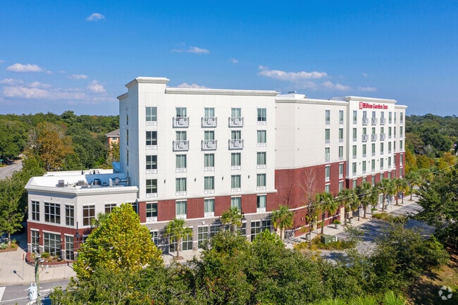
Property Record
300 Wingo Way, Mount Pleasant, SC 29464

NEARBY LISTINGS FOR SALE OR LEASE
Property Detail
300 Wingo Way
514-13-00-070
Remleys Point
Hotel
MAPPLATB L13 MAPPLATP 0307 LOT PARCEL A TRACT 6
AE
Charleston
45019C0517K
South Carolina
2025
2.62 AC
2024
Mount Pleasant/Isle Of Palms
004621
Charleston/N Charleston
12,246 SF
Charleston-North Charleston, SC
DEMOGRAPHICS near 300 Wingo Way
1 Mile
3 Mile
5 Mile
2024 Total Population
6,135
49,001
115,971
2029 Population
6,549
53,298
126,407
Pop Growth 2024-2029
+ 6.75%
+ 8.77%
+ 9.00%
Average Age
42
40
40
2024 Total Households
2,967
21,857
50,674
HH Growth 2024-2029
+ 6.74%
+ 8.90%
+ 9.06%
Median Household Inc
$95,243
$80,286
$88,192
Avg Household Size
2.00
2.10
2.20
2024 Avg HH Vehicles
2.00
2.00
2.00
Median Home Value
$629,975
$651,924
$636,397
Median Year Built
1985
1985
1988
Nearby Places
Map Layers
Map Styles
 Street
 Aerial
- Restaurants
- Banks
- Shops
- Fitness
- Groceries
PUBLIC TRANSPORTATION
COMMUTER RAIL
Charleston Amtrak Station (Palmetto - Amtrak, Silver Meteor - Amtrak)
DRIVE
WALK
Distance
Charleston Amtrak Station (Palmetto - Amtrak, Silver Meteor - Amtrak)
12 min
9.3 mi
AIRPORT
Charleston AFB/International
DRIVE
WALK
Distance
Charleston AFB/International
23 min
15.8 mi
Freight Ports
Columbus Street Terminal
DRIVE
WALK
Distance
Columbus Street Terminal
6 min
3.5 mi
Nearby Properties
Address
Land Use
TOTAL SIZE
Lot Size
Zoning
Address
Land Use
TOTAL SIZE
Lot Size
Zoning
247,883 SF
16.26 AC
Address
Land Use
TOTAL SIZE
Lot Size
Zoning
2,592 SF
13.64 AC
Address
Land Use
TOTAL SIZE
Lot Size
Zoning
Address
Land Use
TOTAL SIZE
Lot Size
Zoning
39,150 SF
7.76 AC
Address
Land Use
TOTAL SIZE
Lot Size
Zoning
Address
Land Use
TOTAL SIZE
Lot Size
Zoning
85,408 SF
9.39 AC
Address
Land Use
TOTAL SIZE
Lot Size
Zoning
480.58 AC
CHARLESTON
Address
Land Use
TOTAL SIZE
Lot Size
Zoning
8,472 SF
9.84 AC
Address
Land Use
TOTAL SIZE
Lot Size
Zoning
8,472 SF
9.83 AC
Address
Land Use
TOTAL SIZE
Lot Size
Zoning
1,435 SF
1.98 AC
Address
Land Use
TOTAL SIZE
Lot Size
Zoning
6.11 AC
Address
Land Use
TOTAL SIZE
Lot Size
Zoning
Address
Land Use
TOTAL SIZE
Lot Size
Zoning
1,282 SF
8.42 AC
Address
Land Use
TOTAL SIZE
Lot Size
Zoning
5,733 SF
0.10 AC
Address
Land Use
TOTAL SIZE
Lot Size
Zoning
14,240 SF
3.50 AC
Address
Land Use
TOTAL SIZE
Lot Size
Zoning
8,740 SF
0.58 AC
Address
Land Use
TOTAL SIZE
Lot Size
Zoning
1,150 SF
Address
Land Use
TOTAL SIZE
Lot Size
Zoning
24,320 SF
1.31 AC
Address
Land Use
TOTAL SIZE
Lot Size
Zoning
15,957 SF
3.80 AC
Address
Land Use
TOTAL SIZE
Lot Size
Zoning
31,094 SF
5.97 AC
Address
Land Use
TOTAL SIZE
Lot Size
Zoning
12,358 SF
15.08 AC
Address
Land Use
TOTAL SIZE
Lot Size
Zoning
6.57 AC
Address
Land Use
TOTAL SIZE
Lot Size
Zoning
34,713 SF
13.51 AC
Address
Land Use
TOTAL SIZE
Lot Size
Zoning
119,711 SF
0.93 AC
Address
Land Use
TOTAL SIZE
Lot Size
Zoning
1.89 AC
Address
Land Use
TOTAL SIZE
Lot Size
Zoning
1,222 SF
13.62 AC
Address
Land Use
TOTAL SIZE
Lot Size
Zoning
2,960 SF
1.62 AC
Address
Land Use
TOTAL SIZE
Lot Size
Zoning
0.72 AC
Address
Land Use
TOTAL SIZE
Lot Size
Zoning
34,460 SF
1.77 AC
Address
Land Use
TOTAL SIZE
Lot Size
Zoning
12,777 SF
2.36 AC
The World's #1 Commercial Real Estate Marketplace
Connect with us
© 2025 CoStar Group
The information above has been obtained from sources believed reliable. While we do not doubt its accuracy we have not verified it and make no guarantee, warranty or representation about it. It is your responsibility to independently confirm its accuracy and completeness. Any projections, opinions, assumptions, or estimates used are for example only and do not represent the current or future performance of the property. The value of this transaction to you depends on tax and other factors which should be evaluated by your tax, financial, and legal advisors. You and your advisors should conduct a careful, independent investigation of the property to determine to your satisfaction the suitability of the property for your needs.