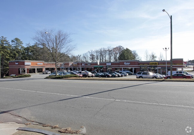
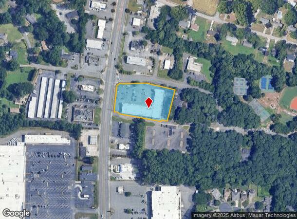
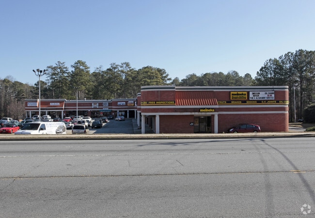
Property Record
3020 Canton Rd, Marietta, GA 30066

Current Lease Availabilities
NEARBY LISTINGS FOR SALE OR LEASE
Property Detail
3020 Canton Rd
16-0493-0-050-0
Shaw Park Stn James Sunbelt Engi
Stripcommercialcenter
Cobb
X
Georgia
13057C0350E
493
2025
1.97 AC
2025
Town Center/Marietta
030361
Atlanta
35,597 SF
Atlanta-Sandy Springs-Roswell, GA
DEMOGRAPHICS near 3020 Canton Rd
1 Mile
3 Mile
5 Mile
2024 Total Population
6,233
62,619
186,588
2029 Population
6,321
63,265
191,648
Pop Growth 2024-2029
+ 1.41%
+ 1.03%
+ 2.71%
Average Age
42
39
39
2024 Total Households
2,307
23,312
70,870
HH Growth 2024-2029
+ 1.43%
+ 0.91%
+ 2.86%
Median Household Inc
$96,628
$94,796
$92,072
Avg Household Size
2.60
2.50
2.50
2024 Avg HH Vehicles
2.00
2.00
2.00
Median Home Value
$324,699
$316,473
$340,742
Median Year Built
1982
1986
1987
Nearby Places
Map Layers
Map Styles
 Street
 Aerial
- Restaurants
- Banks
- Shops
- Fitness
- Groceries
PUBLIC TRANSPORTATION
AIRPORT
Hartsfield - Jackson Atlanta International
DRIVE
WALK
Distance
Hartsfield - Jackson Atlanta International
45 min
32.8 mi
Freight Ports
Georgia Ports - Savannah
DRIVE
WALK
Distance
Georgia Ports - Savannah
308 min
272.1 mi
Nearby Properties
Address
Land Use
TOTAL SIZE
Lot Size
Zoning
Address
Land Use
TOTAL SIZE
Lot Size
Zoning
578,456 SF
60 AC
RM-12
Address
Land Use
TOTAL SIZE
Lot Size
Zoning
4,812 SF
4.20 AC
PVC
Address
Land Use
TOTAL SIZE
Lot Size
Zoning
416,821 SF
12.96 AC
Address
Land Use
TOTAL SIZE
Lot Size
Zoning
35,085 SF
3.77 AC
RRC
Address
Land Use
TOTAL SIZE
Lot Size
Zoning
7.79 AC
RRC
Address
Land Use
TOTAL SIZE
Lot Size
Zoning
382,704 SF
18.72 AC
RM-16
Address
Land Use
TOTAL SIZE
Lot Size
Zoning
352,938 SF
19.86 AC
RM-16
Address
Land Use
TOTAL SIZE
Lot Size
Zoning
326,166 SF
40 AC
RM-12/WS
Address
Land Use
TOTAL SIZE
Lot Size
Zoning
617,562 SF
35.22 AC
PSC
Address
Land Use
TOTAL SIZE
Lot Size
Zoning
300,369 SF
10.64 AC
Address
Land Use
TOTAL SIZE
Lot Size
Zoning
385,954 SF
31 AC
RM-12
Address
Land Use
TOTAL SIZE
Lot Size
Zoning
304,376 SF
19.86 AC
RM-12/WS
Address
Land Use
TOTAL SIZE
Lot Size
Zoning
312,765 SF
12.59 AC
UVC
Address
Land Use
TOTAL SIZE
Lot Size
Zoning
437,231 SF
5.79 AC
PVC
Address
Land Use
TOTAL SIZE
Lot Size
Zoning
3.16 AC
PVC
Address
Land Use
TOTAL SIZE
Lot Size
Zoning
13.46 AC
PVC
Address
Land Use
TOTAL SIZE
Lot Size
Zoning
270,275 SF
21.52 AC
RM-12
Address
Land Use
TOTAL SIZE
Lot Size
Zoning
360,937 SF
32.56 AC
RM-12
Address
Land Use
TOTAL SIZE
Lot Size
Zoning
183,262 SF
19.35 AC
RM-12
Address
Land Use
TOTAL SIZE
Lot Size
Zoning
99,863 SF
21.90 AC
UC
Address
Land Use
TOTAL SIZE
Lot Size
Zoning
27.25 AC
OS
Address
Land Use
TOTAL SIZE
Lot Size
Zoning
320,248 SF
26.67 AC
RM-12
Address
Land Use
TOTAL SIZE
Lot Size
Zoning
232,415 SF
19.23 AC
RM-12
Address
Land Use
TOTAL SIZE
Lot Size
Zoning
281,097 SF
31.52 AC
GC
Address
Land Use
TOTAL SIZE
Lot Size
Zoning
229,440 SF
13 AC
OI
Address
Land Use
TOTAL SIZE
Lot Size
Zoning
182,971 SF
11.28 AC
OS
Address
Land Use
TOTAL SIZE
Lot Size
Zoning
171,286 SF
35.72 AC
CRC
Address
Land Use
TOTAL SIZE
Lot Size
Zoning
367,200 SF
18.44 AC
HI
Address
Land Use
TOTAL SIZE
Lot Size
Zoning
251,598 SF
18.77 AC
GC
Address
Land Use
TOTAL SIZE
Lot Size
Zoning
337,481 SF
26.36 AC
HI
The World's #1 Commercial Real Estate Marketplace
Connect with us
© 2025 CoStar Group
The information above has been obtained from sources believed reliable. While we do not doubt its accuracy we have not verified it and make no guarantee, warranty or representation about it. It is your responsibility to independently confirm its accuracy and completeness. Any projections, opinions, assumptions, or estimates used are for example only and do not represent the current or future performance of the property. The value of this transaction to you depends on tax and other factors which should be evaluated by your tax, financial, and legal advisors. You and your advisors should conduct a careful, independent investigation of the property to determine to your satisfaction the suitability of the property for your needs.