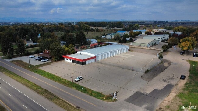
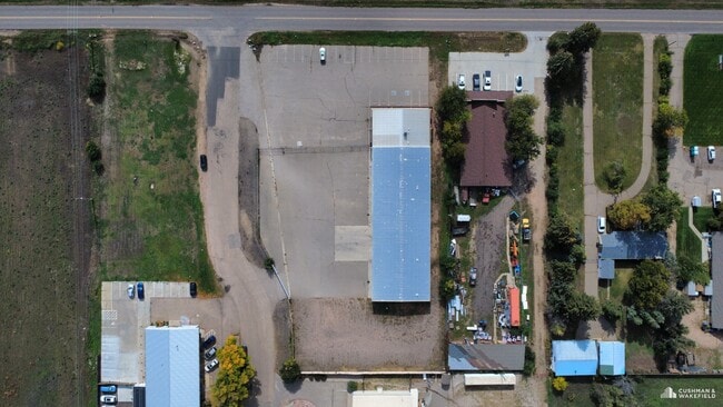
Property Record
3020 E Mulberry St, Fort Collins, CO 80524

Property Detail
3020 E Mulberry St
87084-00-066
TR IN SE 1/4 8-7-68, BEG AT PT ON S LN WH BEARS W 159.59 FT FROM SE COR, TH ALG S LN W 210.14 FT, N 378 FT, E 167.97 FT, S 0 16 E 37.92 FT, TH ALG ARC 130 FT RAD CUR L, 84.1 FT, L/C S 18 48 E 82.64 FT, TH ALG ARC 70 FT RAD CUR R, 45.29 FT, L/C S 18 4
Warehouse
Larimer
T
Colorado
B and X Area of moderate flood hazard, usually the area between the limits of the 100-year and 500-year floods.
84
2024
1.73 AC
2025
Fort Collins/Loveland
001306
Denver
12,000 SF
Fort Collins-Loveland, CO
NEARBY LISTINGS FOR SALE OR LEASE
DEMOGRAPHICS near 3020 E Mulberry St
1 mile
3 mile
5 mile
2024 Total Population
3,588
44,521
140,893
2029 Population
3,793
45,938
146,320
Pop Growth 2024-2029
+ 5.71%
+ 3.18%
+ 3.85%
Average Age
39
38
36
2024 Total Households
1,469
18,209
57,344
HH Growth 2024-2029
+ 5.51%
+ 3.33%
+ 4.33%
Median Household Inc
$88,398
$85,503
$74,470
Avg Household Size
2.40
2.30
2.20
2024 Avg HH Vehicles
2.00
2.00
2.00
Median Home Value
$451,171
$612,488
$618,655
Median Year Built
1985
1993
1992
Nearby Places
Map Layers
Map Styles
 Street
 Aerial
Transit
 Traffic
 Biking
Places
Listings with unknown addresses are not visible on the map
- Restaurants
- Banks
- Shops
- Fitness
- Groceries
Nearby Properties
Address
Land Use
TOTAL SIZE
Lot Size
Zoning
Address
Land Use
TOTAL SIZE
Lot Size
Zoning
850,000 SF
21.76 AC
E
Address
Land Use
TOTAL SIZE
Lot Size
Zoning
251,556 SF
89.99 AC
Address
Land Use
TOTAL SIZE
Lot Size
Zoning
1,311,585 SF
124.82 AC
I
Address
Land Use
TOTAL SIZE
Lot Size
Zoning
360,725 SF
33.93 AC
MMN
Address
Land Use
TOTAL SIZE
Lot Size
Zoning
333,130 SF
47.74 AC
Address
Land Use
TOTAL SIZE
Lot Size
Zoning
180,030 SF
18.80 AC
Address
Land Use
TOTAL SIZE
Lot Size
Zoning
281,945 SF
15.01 AC
NCL
Address
Land Use
TOTAL SIZE
Lot Size
Zoning
98,518 SF
7.54 AC
MMN
Address
Land Use
TOTAL SIZE
Lot Size
Zoning
227,180 SF
39 AC
E
Address
Land Use
TOTAL SIZE
Lot Size
Zoning
312,405 SF
16.01 AC
Address
Land Use
TOTAL SIZE
Lot Size
Zoning
191,673 SF
17.39 AC
I
Address
Land Use
TOTAL SIZE
Lot Size
Zoning
211,255 SF
20.73 AC
C
Address
Land Use
TOTAL SIZE
Lot Size
Zoning
375,679 SF
17.13 AC
Address
Land Use
TOTAL SIZE
Lot Size
Zoning
97,130 SF
8.48 AC
Address
Land Use
TOTAL SIZE
Lot Size
Zoning
87,563 SF
3.15 AC
Address
Land Use
TOTAL SIZE
Lot Size
Zoning
107,170 SF
14.61 AC
Address
Land Use
TOTAL SIZE
Lot Size
Zoning
247,848 SF
17.29 AC
PD
Address
Land Use
TOTAL SIZE
Lot Size
Zoning
116,589 SF
0.87 AC
Address
Land Use
TOTAL SIZE
Lot Size
Zoning
99,997 SF
10.47 AC
NC
Address
Land Use
TOTAL SIZE
Lot Size
Zoning
69,065 SF
11.67 AC
E
Address
Land Use
TOTAL SIZE
Lot Size
Zoning
244,561 SF
9.40 AC
E
Address
Land Use
TOTAL SIZE
Lot Size
Zoning
144,438 SF
5.51 AC
LMN
Address
Land Use
TOTAL SIZE
Lot Size
Zoning
159,950 SF
31.13 AC
I
Address
Land Use
TOTAL SIZE
Lot Size
Zoning
303.46 AC
O
Address
Land Use
TOTAL SIZE
Lot Size
Zoning
232,899 SF
23.52 AC
MMN
Address
Land Use
TOTAL SIZE
Lot Size
Zoning
64,592 SF
1.53 AC
E
Address
Land Use
TOTAL SIZE
Lot Size
Zoning
242,800 SF
1.82 AC
E
Address
Land Use
TOTAL SIZE
Lot Size
Zoning
67,636 SF
12.38 AC
RL
Address
Land Use
TOTAL SIZE
Lot Size
Zoning
100,000 SF
4.88 AC
LMN
Address
Land Use
TOTAL SIZE
Lot Size
Zoning
148,194 SF
2.04 AC
The World's #1 Commercial Real Estate Marketplace
Connect with us
© 2026 CoStar Group
The information above has been obtained from sources believed reliable. While we do not doubt its accuracy we have not verified it and make no guarantee, warranty or representation about it. It is your responsibility to independently confirm its accuracy and completeness. Any projections, opinions, assumptions, or estimates used are for example only and do not represent the current or future performance of the property. The value of this transaction to you depends on tax and other factors which should be evaluated by your tax, financial, and legal advisors. You and your advisors should conduct a careful, independent investigation of the property to determine to your satisfaction the suitability of the property for your needs.