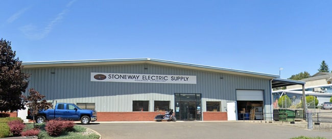
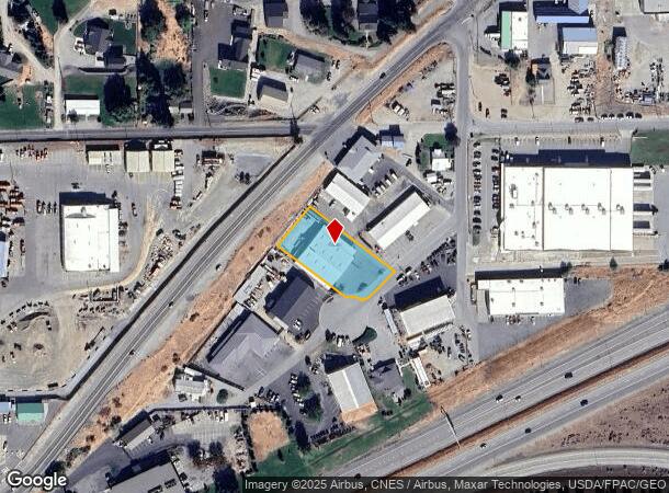
Property Record
3020 Gs Center Rd, Wenatchee, WA 98801
NEARBY LISTINGS FOR SALE OR LEASE
Property Detail
3020 Gs Center Rd
Wenatchee, WA
Gs Center Add Phase Ii
24792
T 23N R 20EWM S 21 PARCEL 12 BINDING SITE B-6 G S CENTER SP6/19 0.6600 ACRES PARCEL 12 BINDING SITE B-6 G S CENTER SP6/19
Storebuilding
Chelan
2024
Washington
2024
0.66 AC
960700
Washington State Area
10,000 SF
Other Market Areas
DEMOGRAPHICS near 3020 Gs Center Rd
1 Mile
3 Mile
5 Mile
2024 Total Population
1,972
21,657
57,507
2029 Population
2,059
22,638
59,901
Pop Growth 2024-2029
+ 4.41%
+ 4.53%
+ 4.16%
Average Age
43
42
40
2024 Total Households
705
8,494
21,876
HH Growth 2024-2029
+ 4.54%
+ 4.46%
+ 4.16%
Median Household Inc
$110,795
$74,096
$69,331
Avg Household Size
2.70
2.50
2.50
2024 Avg HH Vehicles
2.00
2.00
2.00
Median Home Value
$492,187
$415,362
$385,274
Median Year Built
1998
1993
1979
Nearby Places
Map Layers
Map Styles
 Street
 Aerial
- Restaurants
- Banks
- Shops
- Fitness
- Groceries
PUBLIC TRANSPORTATION
COMMUTER RAIL
Wenatchee Amtrak (Empire Builder - Amtrak)
DRIVE
WALK
Distance
Wenatchee Amtrak (Empire Builder - Amtrak)
13 min
5.9 mi
AIRPORT
Pangborn Memorial
DRIVE
WALK
Distance
Pangborn Memorial
24 min
12.0 mi
Freight Ports
Port of Everett
DRIVE
WALK
Distance
Port of Everett
170 min
120.8 mi
SALE & LEASE HISTORY
LISTING DATE
SALE/LEASE

Jul 31, 2023
For Sale
Nearby Properties
Address
Land Use
TOTAL SIZE
Lot Size
Zoning
Address
Land Use
TOTAL SIZE
Lot Size
Zoning
419,838 SF
14.62 AC
Address
Land Use
TOTAL SIZE
Lot Size
Zoning
309,324 SF
6.84 AC
Address
Land Use
TOTAL SIZE
Lot Size
Zoning
375,726 SF
30.12 AC
Address
Land Use
TOTAL SIZE
Lot Size
Zoning
198,833 SF
9.52 AC
Address
Land Use
TOTAL SIZE
Lot Size
Zoning
116,060 SF
6.44 AC
Address
Land Use
TOTAL SIZE
Lot Size
Zoning
197,755 SF
8.35 AC
R-M
Address
Land Use
TOTAL SIZE
Lot Size
Zoning
134,669 SF
7.63 AC
Address
Land Use
TOTAL SIZE
Lot Size
Zoning
56,645 SF
6.35 AC
Address
Land Use
TOTAL SIZE
Lot Size
Zoning
91,804 SF
10.26 AC
Address
Land Use
TOTAL SIZE
Lot Size
Zoning
7,174 SF
14.47 AC
I-G
Address
Land Use
TOTAL SIZE
Lot Size
Zoning
104,070 SF
3.11 AC
Address
Land Use
TOTAL SIZE
Lot Size
Zoning
73,830 SF
6.29 AC
Address
Land Use
TOTAL SIZE
Lot Size
Zoning
108,000 SF
7.05 AC
Address
Land Use
TOTAL SIZE
Lot Size
Zoning
65,430 SF
9 AC
Address
Land Use
TOTAL SIZE
Lot Size
Zoning
159,039 SF
16.21 AC
Address
Land Use
TOTAL SIZE
Lot Size
Zoning
57,520 SF
3.52 AC
Address
Land Use
TOTAL SIZE
Lot Size
Zoning
168,028 SF
21.20 AC
Address
Land Use
TOTAL SIZE
Lot Size
Zoning
148,977 SF
11.06 AC
Address
Land Use
TOTAL SIZE
Lot Size
Zoning
42,032 SF
4.27 AC
Address
Land Use
TOTAL SIZE
Lot Size
Zoning
67,932 SF
5.58 AC
Address
Land Use
TOTAL SIZE
Lot Size
Zoning
77,245 SF
21.02 AC
RR-20
Address
Land Use
TOTAL SIZE
Lot Size
Zoning
97,509 SF
5.71 AC
Address
Land Use
TOTAL SIZE
Lot Size
Zoning
142,150 SF
10.46 AC
Address
Land Use
TOTAL SIZE
Lot Size
Zoning
56,105 SF
6.03 AC
Address
Land Use
TOTAL SIZE
Lot Size
Zoning
89,736 SF
6.96 AC
Address
Land Use
TOTAL SIZE
Lot Size
Zoning
47,774 SF
5.02 AC
Address
Land Use
TOTAL SIZE
Lot Size
Zoning
43,367 SF
1.50 AC
Address
Land Use
TOTAL SIZE
Lot Size
Zoning
94,989 SF
8.63 AC
Address
Land Use
TOTAL SIZE
Lot Size
Zoning
30,075 SF
5.82 AC
Address
Land Use
TOTAL SIZE
Lot Size
Zoning
61,000 SF
4.98 AC
The World's #1 Commercial Real Estate Marketplace
Connect with us
© 2025 CoStar Group
The information above has been obtained from sources believed reliable. While we do not doubt its accuracy we have not verified it and make no guarantee, warranty or representation about it. It is your responsibility to independently confirm its accuracy and completeness. Any projections, opinions, assumptions, or estimates used are for example only and do not represent the current or future performance of the property. The value of this transaction to you depends on tax and other factors which should be evaluated by your tax, financial, and legal advisors. You and your advisors should conduct a careful, independent investigation of the property to determine to your satisfaction the suitability of the property for your needs.