Property Record
3020 S Miami Blvd, Durham, NC 27703


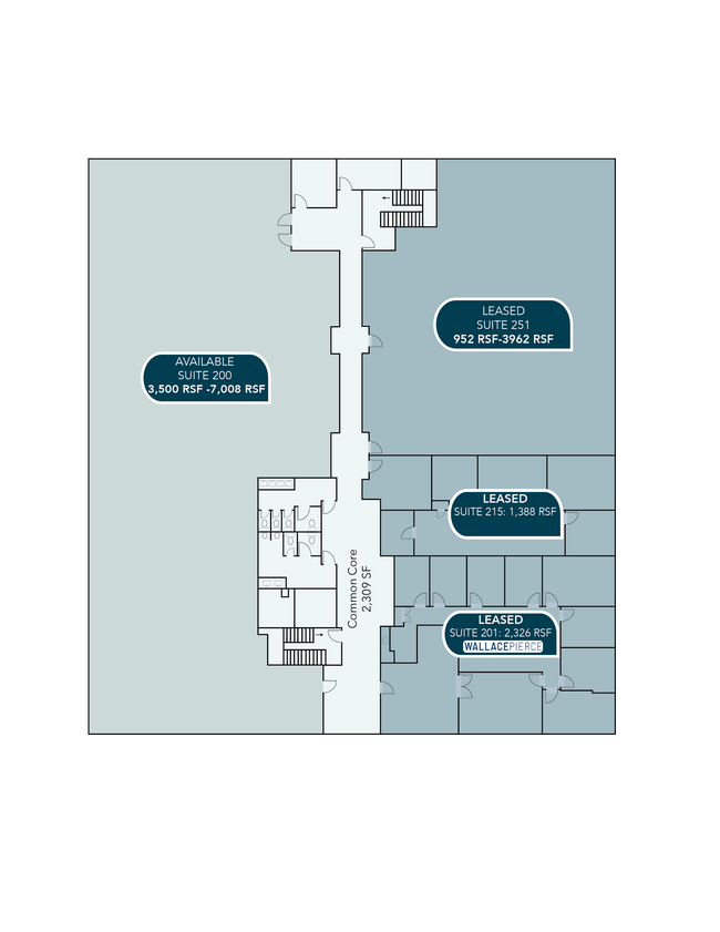

Current Lease Availabilities
NEARBY LISTINGS FOR SALE OR LEASE
Property Detail
3020 S Miami Blvd
157277
Surveyed And Mapped For 3020 S Miami Bou
Officebuilding
PROP-PARKER-RALEIGH DEV X LTD PRTNRSHP/CELL SITE D PL:000000-000000
X
Durham
3720074900K
North Carolina
2024
2.86 AC
2025
Research Triangle
001809
Raleigh/Durham
31,688 SF
Durham-Chapel Hill, NC
DEMOGRAPHICS near 3020 S Miami Blvd
1 mile
3 mile
5 mile
2024 Total Population
2,234
37,831
143,364
2029 Population
2,435
40,139
151,333
Pop Growth 2024-2029
+ 9.00%
+ 6.10%
+ 5.56%
Average Age
41
38
38
2024 Total Households
1,037
17,153
60,673
HH Growth 2024-2029
+ 9.35%
+ 6.34%
+ 5.86%
Median Household Inc
$95,928
$89,693
$77,711
Avg Household Size
2.10
2.20
2.30
2024 Avg HH Vehicles
2.00
2.00
2.00
Median Home Value
$312,590
$340,302
$305,884
Median Year Built
2009
2008
2002
Nearby Places
Map Layers
Map Styles
 Street
 Aerial
Transit
 Traffic
 Biking
Places
Listings with unknown addresses are not visible on the map
- Restaurants
- Banks
- Shops
- Fitness
- Groceries
PUBLIC TRANSPORTATION
COMMUTER RAIL
Drive
Walk
Distance
12 min
7.1 mi
AIRPORT
Raleigh-Durham International
Drive
Walk
Distance
Raleigh-Durham International
14 min
7.7 mi
Nearby Properties
Address
Land Use
TOTAL SIZE
Lot Size
Zoning
Address
Land Use
TOTAL SIZE
Lot Size
Zoning
2,436,024 SF
SRP
Address
Land Use
TOTAL SIZE
Lot Size
Zoning
875,384 SF
111.74 AC
SRP
Address
Land Use
TOTAL SIZE
Lot Size
Zoning
1,080,486 SF
61.68 AC
SRP
Address
Land Use
TOTAL SIZE
Lot Size
Zoning
677,504 SF
60.32 AC
SRP
Address
Land Use
TOTAL SIZE
Lot Size
Zoning
29.13 AC
CG(D)
Address
Land Use
TOTAL SIZE
Lot Size
Zoning
1,272,163 SF
117.61 AC
OI,SRP
Address
Land Use
TOTAL SIZE
Lot Size
Zoning
1,378,965 SF
183.46 AC
SRP
Address
Land Use
TOTAL SIZE
Lot Size
Zoning
868,283 SF
56.23 AC
SRP
Address
Land Use
TOTAL SIZE
Lot Size
Zoning
491,701 SF
124.48 AC
SRP
Address
Land Use
TOTAL SIZE
Lot Size
Zoning
799,818 SF
84.58 AC
IL
Address
Land Use
TOTAL SIZE
Lot Size
Zoning
444,254 SF
58.71 AC
SRP
Address
Land Use
TOTAL SIZE
Lot Size
Zoning
11,670 SF
41.27 AC
RS-M(D)
Address
Land Use
TOTAL SIZE
Lot Size
Zoning
15,252 SF
29.36 AC
RS-M
Address
Land Use
TOTAL SIZE
Lot Size
Zoning
35.03 AC
RS-M(D)
Address
Land Use
TOTAL SIZE
Lot Size
Zoning
2,922 SF
30.57 AC
PDR 4.840
Address
Land Use
TOTAL SIZE
Lot Size
Zoning
319,275 SF
50.52 AC
SRP
Address
Land Use
TOTAL SIZE
Lot Size
Zoning
353,339 SF
25.95 AC
SRP
Address
Land Use
TOTAL SIZE
Lot Size
Zoning
21.29 AC
CG(D)
Address
Land Use
TOTAL SIZE
Lot Size
Zoning
2.82 AC
SRP-C
Address
Land Use
TOTAL SIZE
Lot Size
Zoning
441,280 SF
48.43 AC
IL
Address
Land Use
TOTAL SIZE
Lot Size
Zoning
529,439 SF
29.84 AC
IL
Address
Land Use
TOTAL SIZE
Lot Size
Zoning
300,042 SF
41.03 AC
SRP
Address
Land Use
TOTAL SIZE
Lot Size
Zoning
21.83 AC
OI
Address
Land Use
TOTAL SIZE
Lot Size
Zoning
555,485 SF
34.84 AC
SRP
Address
Land Use
TOTAL SIZE
Lot Size
Zoning
28,632 SF
23.64 AC
PDR 3.990
Address
Land Use
TOTAL SIZE
Lot Size
Zoning
278,044 SF
17.79 AC
RX-3
Address
Land Use
TOTAL SIZE
Lot Size
Zoning
456,072 SF
35.73 AC
IP
Address
Land Use
TOTAL SIZE
Lot Size
Zoning
6,180 SF
26.56 AC
RS-M(D)
Address
Land Use
TOTAL SIZE
Lot Size
Zoning
24,012 SF
19.61 AC
RS-M(D)
Address
Land Use
TOTAL SIZE
Lot Size
Zoning
10,572 SF
27.56 AC
RS-M(D)
The World's #1 Commercial Real Estate Marketplace
Connect with us
© 2026 CoStar Group
The information above has been obtained from sources believed reliable. While we do not doubt its accuracy we have not verified it and make no guarantee, warranty or representation about it. It is your responsibility to independently confirm its accuracy and completeness. Any projections, opinions, assumptions, or estimates used are for example only and do not represent the current or future performance of the property. The value of this transaction to you depends on tax and other factors which should be evaluated by your tax, financial, and legal advisors. You and your advisors should conduct a careful, independent investigation of the property to determine to your satisfaction the suitability of the property for your needs.