Property Record
3020 Sw 67Th Avenue Rd, Ocala, FL 34474

NEARBY LISTINGS FOR SALE OR LEASE
Property Detail
3020 Sw 67Th Avenue Rd
23820-016-00
SEC 29 TWP 15 RGE 21 E 1/2 OF NW 1/4 & W 40 FT OF W 1/4 OF E 1/2 OF SW 1/4 & E 1/2 OF W 1/2 OF E 1/2 OF SW 1/4 & E 1/2 OF E 1/2 OF E 1/2 OF SW 1/4 & COM AT NE COR OF SW 1/4 OF SEC 29 TH N 89-58-06 W 329.77 FT TO NE COR OF W 1/2 OF E 1/4 OF SW 1/4 & P
Vacantlandnec
Marion
A
Florida
12083C0511E
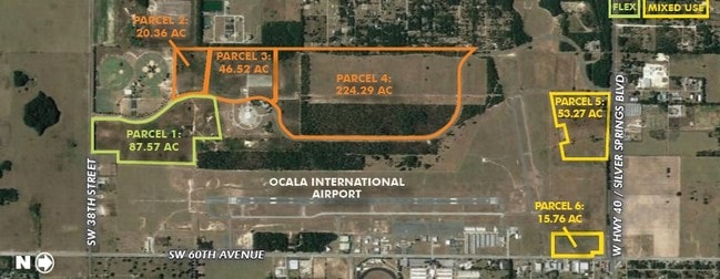
209.42 AC
0
Greater Ocala
2025
Ocala
002507
Ocala, FL
1,766 SF
DEMOGRAPHICS near 3020 Sw 67Th Avenue Rd
1 Mile
3 Mile
5 Mile
2024 Total Population
212
16,354
50,317
2029 Population
239
18,396
56,991
Pop Growth 2024-2029
+ 12.74%
+ 12.49%
+ 13.26%
Average Age
43
42
48
2024 Total Households
82
6,803
21,830
HH Growth 2024-2029
+ 12.20%
+ 12.41%
+ 13.39%
Median Household Inc
$68,076
$58,829
$57,018
Avg Household Size
2.50
2.30
2.20
2024 Avg HH Vehicles
2.00
2.00
1.00
Median Home Value
$263,888
$207,161
$236,128
Median Year Built
1996
1994
1998
Nearby Places
Map Layers
Map Styles
 Street
 Aerial
- Restaurants
- Banks
- Shops
- Fitness
- Groceries
SALE & LEASE HISTORY
LISTING DATE
SALE/LEASE

Jun 21, 2017
For Sale
Nearby Properties
Address
Land Use
TOTAL SIZE
Lot Size
Zoning
Address
Land Use
TOTAL SIZE
Lot Size
Zoning
2,015,469 SF
169.30 AC
M1
Address
Land Use
TOTAL SIZE
Lot Size
Zoning
493,261 SF
126.01 AC
R3
Address
Land Use
TOTAL SIZE
Lot Size
Zoning
156,201 SF
36.77 AC
INST
Address
Land Use
TOTAL SIZE
Lot Size
Zoning
120,296 SF
35.67 AC
PD
Address
Land Use
TOTAL SIZE
Lot Size
Zoning
192,480 SF
23.19 AC
R3
Address
Land Use
TOTAL SIZE
Lot Size
Zoning
164,363 SF
16.51 AC
R3
Address
Land Use
TOTAL SIZE
Lot Size
Zoning
324,262 SF
40.79 AC
SC
Address
Land Use
TOTAL SIZE
Lot Size
Zoning
189,662 SF
25.54 AC
B2
Address
Land Use
TOTAL SIZE
Lot Size
Zoning
87,034 SF
14.45 AC
R3
Address
Land Use
TOTAL SIZE
Lot Size
Zoning
322,193 SF
70.13 AC
INST
Address
Land Use
TOTAL SIZE
Lot Size
Zoning
152,355 SF
973.50 AC
GU
Address
Land Use
TOTAL SIZE
Lot Size
Zoning
422,369 SF
51.11 AC
M2
Address
Land Use
TOTAL SIZE
Lot Size
Zoning
194,275 SF
13.43 AC
M1
Address
Land Use
TOTAL SIZE
Lot Size
Zoning
186,474 SF
18.52 AC
SC
Address
Land Use
TOTAL SIZE
Lot Size
Zoning
59,706 SF
10.01 AC
PD
Address
Land Use
TOTAL SIZE
Lot Size
Zoning
392,617 SF
23.83 AC
M1
Address
Land Use
TOTAL SIZE
Lot Size
Zoning
113,501 SF
68.56 AC
INST
Address
Land Use
TOTAL SIZE
Lot Size
Zoning
364,404 SF
31.83 AC
M1
Address
Land Use
TOTAL SIZE
Lot Size
Zoning
92,095 SF
216.43 AC
M1
Address
Land Use
TOTAL SIZE
Lot Size
Zoning
360,450 SF
20 AC
M1
Address
Land Use
TOTAL SIZE
Lot Size
Zoning
95,496 SF
25.25 AC
R3
Address
Land Use
TOTAL SIZE
Lot Size
Zoning
37,601 SF
3.71 AC
B2
Address
Land Use
TOTAL SIZE
Lot Size
Zoning
39,411 SF
3.35 AC
B2
Address
Land Use
TOTAL SIZE
Lot Size
Zoning
265,793 SF
30 AC
M1
Address
Land Use
TOTAL SIZE
Lot Size
Zoning
68,372 SF
21.78 AC
B4
Address
Land Use
TOTAL SIZE
Lot Size
Zoning
44,276 SF
5 AC
O1
Address
Land Use
TOTAL SIZE
Lot Size
Zoning
201,556 SF
16.50 AC
M1
Address
Land Use
TOTAL SIZE
Lot Size
Zoning
10,494 SF
1.63 AC
B2
Address
Land Use
TOTAL SIZE
Lot Size
Zoning
16,016 SF
2.63 AC
B2
Address
Land Use
TOTAL SIZE
Lot Size
Zoning
23,441 SF
2.33 AC
B2
The World's #1 Commercial Real Estate Marketplace
Connect with us
© 2026 CoStar Group
The information above has been obtained from sources believed reliable. While we do not doubt its accuracy we have not verified it and make no guarantee, warranty or representation about it. It is your responsibility to independently confirm its accuracy and completeness. Any projections, opinions, assumptions, or estimates used are for example only and do not represent the current or future performance of the property. The value of this transaction to you depends on tax and other factors which should be evaluated by your tax, financial, and legal advisors. You and your advisors should conduct a careful, independent investigation of the property to determine to your satisfaction the suitability of the property for your needs.