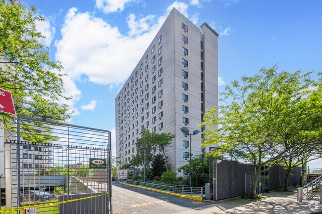
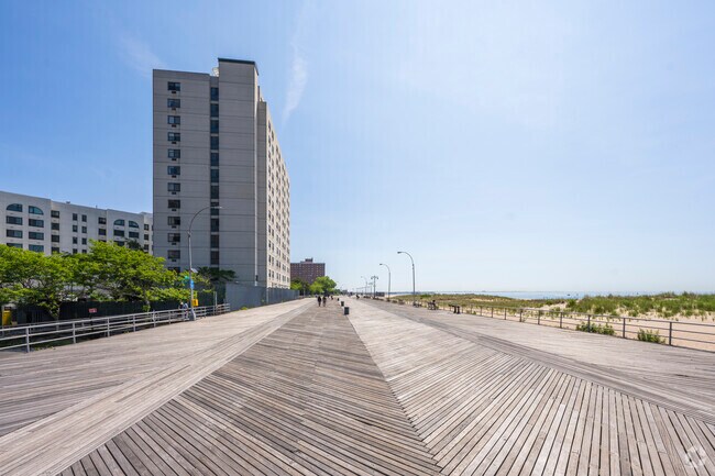
Property Record
3020 W 28Th St, Brooklyn, NY 11224

Save to a Folder
{{folder.Name}}
{{folder.ListingIds.length}} Properties
{{folder.ListingIds.length}} Property
Create a New Folder
Property Detail
3020 W 28Th St
07068-0030
KINGS
Governmentalpublicusegeneral
New York
R6
30
AE The base floodplain where base flood elevations are provided. AE Zones are now used on new format FIRMs instead of A1-A30 Zones.
0.76 AC
0
Coney Island
2026
Long Island (New York)
032600
New York-Jersey City-White Plains, NY-NJ
90,000 SF
NEARBY LISTINGS FOR SALE OR LEASE
DEMOGRAPHICS near 3020 W 28Th St
1 mile
3 mile
5 mile
2025 Total Population
39,716
343,433
960,541
2030 Population
40,985
337,184
941,630
Pop Growth 2025-2030
+ 3.20%
(1.82%)
(1.97%)
Average Age
44
43
41
2025 Total Households
15,047
124,372
328,980
HH Growth 2025-2030
+ 2.98%
(2.04%)
(2.10%)
Median Household Inc
$33,302
$59,514
$69,410
Avg Household Size
2.40
2.60
2.80
2025 Avg HH Vehicles
.00
1.00
1.00
Median Home Value
$777,591
$865,083
$853,878
Median Year Built
1970
1951
1948
Nearby Places
Map Layers
Map Styles
 Street
 Aerial
Layers
 Traffic
 Biking
Places
Listings with unknown addresses are not visible on the map
- Restaurants
- Banks
- Shops
- Fitness
- Groceries
PUBLIC TRANSPORTATION
TRANSIT/SUBWAY
Coney Island-Stillwell Avenue (D - New York MTA Subway (The Subway), F - New York MTA Subway (The Subway), N - New York MTA Subway (The Subway), Q - New York MTA Subway (The Subway))
Drive
Walk
Distance
Coney Island-Stillwell Avenue (D - New York MTA Subway (The Subway), F - New York MTA Subway (The Subway), N - New York MTA Subway (The Subway), Q - New York MTA Subway (The Subway))
3 min
18 min
0.9 mi
COMMUTER RAIL
Grasmere (Staten Island Railway - New York MTA Subway (The Subway))
Drive
Walk
Distance
Grasmere (Staten Island Railway - New York MTA Subway (The Subway))
18 min
8.6 mi
Old Town (Staten Island Railway - New York MTA Subway (The Subway))
Drive
Walk
Distance
Old Town (Staten Island Railway - New York MTA Subway (The Subway))
19 min
8.8 mi
AIRPORT
John F Kennedy International
Drive
Walk
Distance
John F Kennedy International
26 min
17.0 mi
Newark Liberty International
Drive
Walk
Distance
Newark Liberty International
39 min
23.7 mi
LaGuardia
Drive
Walk
Distance
LaGuardia
37 min
23.8 mi
Freight Ports
NY - Red Hook Container Terminal
Drive
Walk
Distance
NY - Red Hook Container Terminal
18 min
9.5 mi
Nearby Properties
Address
Land Use
TOTAL SIZE
Lot Size
Zoning
Address
Land Use
TOTAL SIZE
Lot Size
Zoning
1,078,317 SF
10.45 AC
R4
Address
Land Use
TOTAL SIZE
Lot Size
Zoning
54.78 AC
PARK
Address
Land Use
TOTAL SIZE
Lot Size
Zoning
301,400 SF
22.27 AC
M3-1
Address
Land Use
TOTAL SIZE
Lot Size
Zoning
222,265 SF
0.74 AC
R6
Address
Land Use
TOTAL SIZE
Lot Size
Zoning
139,557 SF
11.47 AC
M1-1
Address
Land Use
TOTAL SIZE
Lot Size
Zoning
275,163 SF
9.69 AC
R3-1
Address
Land Use
TOTAL SIZE
Lot Size
Zoning
59,063 SF
21.56 AC
PARK
Address
Land Use
TOTAL SIZE
Lot Size
Zoning
209,346 SF
18.29 AC
PARK
Address
Land Use
TOTAL SIZE
Lot Size
Zoning
846,056 SF
20.71 AC
R5
Address
Land Use
TOTAL SIZE
Lot Size
Zoning
702,770 SF
4.47 AC
R6
Address
Land Use
TOTAL SIZE
Lot Size
Zoning
292,528 SF
1.05 AC
R6
Address
Land Use
TOTAL SIZE
Lot Size
Zoning
356,000 SF
8.19 AC
R5
Address
Land Use
TOTAL SIZE
Lot Size
Zoning
221,704 SF
0.83 AC
R5B
Address
Land Use
TOTAL SIZE
Lot Size
Zoning
208,015 SF
1.52 AC
R7X
Address
Land Use
TOTAL SIZE
Lot Size
Zoning
128,170 SF
0.87 AC
R7A
Address
Land Use
TOTAL SIZE
Lot Size
Zoning
105,328 SF
0.11 AC
M1-6
Address
Land Use
TOTAL SIZE
Lot Size
Zoning
470,000 SF
3.40 AC
R6
Address
Land Use
TOTAL SIZE
Lot Size
Zoning
60,288 SF
0.76 AC
R5
Address
Land Use
TOTAL SIZE
Lot Size
Zoning
305,046 SF
8.76 AC
R6
Address
Land Use
TOTAL SIZE
Lot Size
Zoning
365,776 SF
7.99 AC
R5
Address
Land Use
TOTAL SIZE
Lot Size
Zoning
470,000 SF
3.30 AC
R6
Address
Land Use
TOTAL SIZE
Lot Size
Zoning
115,825 SF
23.56 AC
M3-1
Address
Land Use
TOTAL SIZE
Lot Size
Zoning
141,830 SF
0.22 AC
C64X
Address
Land Use
TOTAL SIZE
Lot Size
Zoning
547,448 SF
12.50 AC
R5
Address
Land Use
TOTAL SIZE
Lot Size
Zoning
148,861 SF
13.70 AC
C8-1
Address
Land Use
TOTAL SIZE
Lot Size
Zoning
334,000 SF
5.40 AC
R6
Address
Land Use
TOTAL SIZE
Lot Size
Zoning
332,328 SF
2.76 AC
R6
Address
Land Use
TOTAL SIZE
Lot Size
Zoning
3,514 SF
75.40 AC
PARK
Address
Land Use
TOTAL SIZE
Lot Size
Zoning
366,000 SF
3.80 AC
R6
Address
Land Use
TOTAL SIZE
Lot Size
Zoning
230,440 SF
0.56 AC
The World's #1 Commercial Real Estate Marketplace
Connect with us
© 2026 CoStar Group
The information above has been obtained from sources believed reliable. While we do not doubt its accuracy we have not verified it and make no guarantee, warranty or representation about it. It is your responsibility to independently confirm its accuracy and completeness. Any projections, opinions, assumptions, or estimates used are for example only and do not represent the current or future performance of the property. The value of this transaction to you depends on tax and other factors which should be evaluated by your tax, financial, and legal advisors. You and your advisors should conduct a careful, independent investigation of the property to determine to your satisfaction the suitability of the property for your needs.