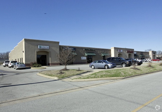
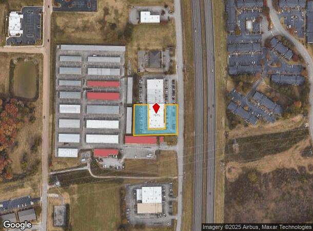
Property Record
3021 Highway 45 Byp, Jackson, TN 38305
NEARBY LISTINGS FOR SALE OR LEASE
Property Detail
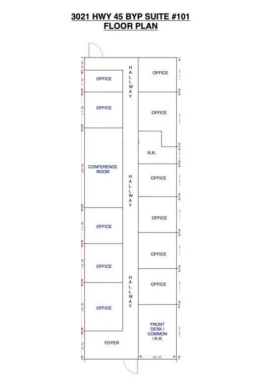
3021 Highway 45 Byp
Jackson, TN
University Park
044B-D-002.00
UNIVERSITY PARK PB 0010 PG 0045 BLK 0004 LOT 0002A REV PB10 PG134 196.86X269.81 IRR
Publichealthcarefacility
Madison
X
Tennessee
47113C0153E
2a
0
1.19 AC
2025
Tennessee West Area
001612
Other Market Areas
DEMOGRAPHICS near 3021 Highway 45 Byp
1 Mile
3 Mile
5 Mile
2024 Total Population
5,706
32,769
53,275
2029 Population
5,678
32,653
53,185
Pop Growth 2024-2029
(0.49%)
(0.35%)
(0.17%)
Average Age
39
40
40
2024 Total Households
2,566
12,864
21,338
HH Growth 2024-2029
(0.47%)
(0.40%)
(0.19%)
Median Household Inc
$55,841
$68,820
$60,269
Avg Household Size
2.20
2.40
2.40
2024 Avg HH Vehicles
2.00
2.00
2.00
Median Home Value
$177,525
$219,544
$194,818
Median Year Built
1989
1991
1987
Nearby Places
Map Layers
Map Styles
 Street
 Aerial
- Restaurants
- Banks
- Shops
- Fitness
- Groceries
SALE & LEASE HISTORY
LISTING DATE
SALE/LEASE

Sep 25, 2016
For Lease
Nov 29, 2016
For Lease
Mar 02, 2023
For Lease
Nearby Properties
Address
Land Use
TOTAL SIZE
Lot Size
Zoning
Address
Land Use
TOTAL SIZE
Lot Size
Zoning
284,540 SF
171 AC
Address
Land Use
TOTAL SIZE
Lot Size
Zoning
542,496 SF
117.50 AC
Address
Land Use
TOTAL SIZE
Lot Size
Zoning
189,152 SF
11.10 AC
B1
Address
Land Use
TOTAL SIZE
Lot Size
Zoning
125,254 SF
128 AC
Address
Land Use
TOTAL SIZE
Lot Size
Zoning
91,033 SF
29 AC
Address
Land Use
TOTAL SIZE
Lot Size
Zoning
117,028 SF
71 AC
Address
Land Use
TOTAL SIZE
Lot Size
Zoning
77,212 SF
25.43 AC
Address
Land Use
TOTAL SIZE
Lot Size
Zoning
37,754 SF
12.70 AC
SC-1
Address
Land Use
TOTAL SIZE
Lot Size
Zoning
378,995 SF
26.30 AC
RG-3
Address
Land Use
TOTAL SIZE
Lot Size
Zoning
128,490 SF
16 AC
Address
Land Use
TOTAL SIZE
Lot Size
Zoning
80,000 SF
15 AC
Address
Land Use
TOTAL SIZE
Lot Size
Zoning
176,093 SF
20.76 AC
Address
Land Use
TOTAL SIZE
Lot Size
Zoning
675,000 SF
111 AC
Address
Land Use
TOTAL SIZE
Lot Size
Zoning
47,579 SF
7 AC
Address
Land Use
TOTAL SIZE
Lot Size
Zoning
133,632 SF
10 AC
Address
Land Use
TOTAL SIZE
Lot Size
Zoning
35,116 SF
3.40 AC
Address
Land Use
TOTAL SIZE
Lot Size
Zoning
69,728 SF
6.59 AC
Address
Land Use
TOTAL SIZE
Lot Size
Zoning
59,592 SF
15.90 AC
Address
Land Use
TOTAL SIZE
Lot Size
Zoning
44,875 SF
6.95 AC
Address
Land Use
TOTAL SIZE
Lot Size
Zoning
400,000 SF
25.21 AC
Address
Land Use
TOTAL SIZE
Lot Size
Zoning
199,026 SF
20 AC
SC1
Address
Land Use
TOTAL SIZE
Lot Size
Zoning
214,096 SF
11.92 AC
RG2
Address
Land Use
TOTAL SIZE
Lot Size
Zoning
607,029 SF
212 AC
I3
Address
Land Use
TOTAL SIZE
Lot Size
Zoning
56,609 SF
10 AC
Address
Land Use
TOTAL SIZE
Lot Size
Zoning
21,864 SF
3.90 AC
Address
Land Use
TOTAL SIZE
Lot Size
Zoning
130,000 SF
9.73 AC
Address
Land Use
TOTAL SIZE
Lot Size
Zoning
489,450 SF
68.50 AC
Address
Land Use
TOTAL SIZE
Lot Size
Zoning
302,500 SF
28.71 AC
Address
Land Use
TOTAL SIZE
Lot Size
Zoning
300,000 SF
11 AC
Address
Land Use
TOTAL SIZE
Lot Size
Zoning
300,000 SF
10 AC
The World's #1 Commercial Real Estate Marketplace
Connect with us
© 2025 CoStar Group
The information above has been obtained from sources believed reliable. While we do not doubt its accuracy we have not verified it and make no guarantee, warranty or representation about it. It is your responsibility to independently confirm its accuracy and completeness. Any projections, opinions, assumptions, or estimates used are for example only and do not represent the current or future performance of the property. The value of this transaction to you depends on tax and other factors which should be evaluated by your tax, financial, and legal advisors. You and your advisors should conduct a careful, independent investigation of the property to determine to your satisfaction the suitability of the property for your needs.