Property Record
3021 Ridge Rd, Rockwall, TX 75032
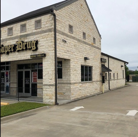


Property Detail
3021 Ridge Rd
Dallas-Fort Worth-Arlington, TX
HORIZON RIDGE ADDITION, BLOCK A, LOT 27, ACRES 0.517, (REPLAT 2004, 2005), (REPLAT 2014)
86405
Rockwall
Commercialnec
Texas
B and X Area of moderate flood hazard, usually the area between the limits of the 100-year and 500-year floods.
27
2024
0.52 AC
2025
Rockwall
040507
Dallas/Ft Worth
4,523 SF
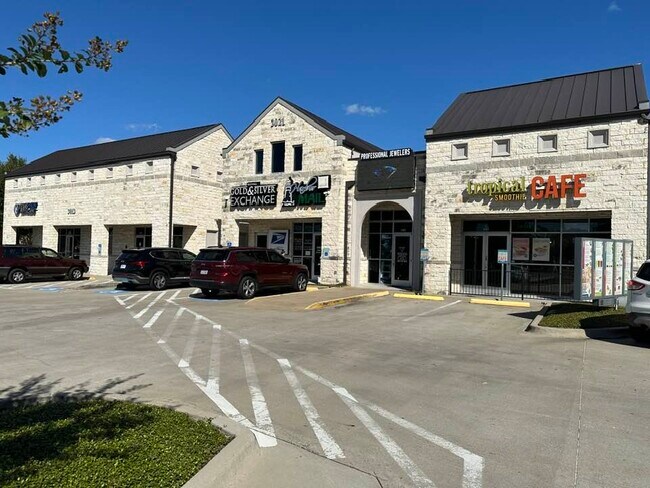
NEARBY LISTINGS FOR SALE OR LEASE
DEMOGRAPHICS near 3021 Ridge Rd
1 mile
3 mile
5 mile
2025 Total Population
10,945
46,335
109,234
2030 Population
13,051
54,606
125,345
Pop Growth 2025-2030
+ 19.24%
+ 17.85%
+ 14.75%
Average Age
43
40
39
2025 Total Households
4,334
17,231
38,978
HH Growth 2025-2030
+ 19.34%
+ 17.79%
+ 14.71%
Median Household Inc
$92,496
$94,134
$102,177
Avg Household Size
2.50
2.60
2.70
2025 Avg HH Vehicles
2.00
2.00
2.00
Median Home Value
$387,182
$382,901
$401,496
Median Year Built
2001
2001
2000
Nearby Places
Map Layers
Map Styles
 Street
 Aerial
Layers
 Traffic
 Biking
Places
Listings with unknown addresses are not visible on the map
- Restaurants
- Banks
- Shops
- Fitness
- Groceries
PUBLIC TRANSPORTATION
AIRPORT
Dallas Love Field
Drive
Walk
Distance
Dallas Love Field
40 min
26.5 mi
Dallas-Fort Worth International
Drive
Walk
Distance
Dallas-Fort Worth International
52 min
43.2 mi
SALE & LEASE HISTORY
LISTING DATE
SALE/LEASE

Sep 23, 2024
For Lease
Jun 05, 2019
For Lease
Nearby Properties
Address
Land Use
TOTAL SIZE
Lot Size
Zoning
Address
Land Use
TOTAL SIZE
Lot Size
Zoning
559,567 SF
10.85 AC
Z80
Address
Land Use
TOTAL SIZE
Lot Size
Zoning
326,761 SF
23.09 AC
Address
Land Use
TOTAL SIZE
Lot Size
Zoning
193,393 SF
80 AC
Address
Land Use
TOTAL SIZE
Lot Size
Zoning
252,909 SF
11.73 AC
Address
Land Use
TOTAL SIZE
Lot Size
Zoning
283,096 SF
10.18 AC
Z80
Address
Land Use
TOTAL SIZE
Lot Size
Zoning
454,141 SF
4.86 AC
Address
Land Use
TOTAL SIZE
Lot Size
Zoning
44,191 SF
32.66 AC
Address
Land Use
TOTAL SIZE
Lot Size
Zoning
326,408 SF
74.12 AC
Address
Land Use
TOTAL SIZE
Lot Size
Zoning
288,677 SF
41.65 AC
P11
Address
Land Use
TOTAL SIZE
Lot Size
Zoning
238,085 SF
34.49 AC
Address
Land Use
TOTAL SIZE
Lot Size
Zoning
413,908 SF
35.30 AC
Address
Land Use
TOTAL SIZE
Lot Size
Zoning
282,628 SF
4.03 AC
Address
Land Use
TOTAL SIZE
Lot Size
Zoning
710,600 SF
3.91 AC
Z80
Address
Land Use
TOTAL SIZE
Lot Size
Zoning
157,834 SF
30.89 AC
Address
Land Use
TOTAL SIZE
Lot Size
Zoning
214,166 SF
21.42 AC
Address
Land Use
TOTAL SIZE
Lot Size
Zoning
198,270 SF
21.48 AC
Address
Land Use
TOTAL SIZE
Lot Size
Zoning
250,627 SF
18.17 AC
Address
Land Use
TOTAL SIZE
Lot Size
Zoning
153,541 SF
27.44 AC
Address
Land Use
TOTAL SIZE
Lot Size
Zoning
495,735 SF
2.92 AC
Z80
Address
Land Use
TOTAL SIZE
Lot Size
Zoning
138,183 SF
4.76 AC
Z80
Address
Land Use
TOTAL SIZE
Lot Size
Zoning
77,891 SF
11.61 AC
A
Address
Land Use
TOTAL SIZE
Lot Size
Zoning
242,845 SF
16.01 AC
Address
Land Use
TOTAL SIZE
Lot Size
Zoning
144,725 SF
12.89 AC
Address
Land Use
TOTAL SIZE
Lot Size
Zoning
227,296 SF
2.14 AC
Address
Land Use
TOTAL SIZE
Lot Size
Zoning
226,384 SF
36.03 AC
Address
Land Use
TOTAL SIZE
Lot Size
Zoning
196,981 SF
8.92 AC
Address
Land Use
TOTAL SIZE
Lot Size
Zoning
211,790 SF
11.58 AC
MF1
Address
Land Use
TOTAL SIZE
Lot Size
Zoning
245,501 SF
6.65 AC
Address
Land Use
TOTAL SIZE
Lot Size
Zoning
85,912 SF
5.93 AC
Address
Land Use
TOTAL SIZE
Lot Size
Zoning
174,826 SF
11.13 AC
The World's #1 Commercial Real Estate Marketplace
Connect with us
© 2026 CoStar Group
The information above has been obtained from sources believed reliable. While we do not doubt its accuracy we have not verified it and make no guarantee, warranty or representation about it. It is your responsibility to independently confirm its accuracy and completeness. Any projections, opinions, assumptions, or estimates used are for example only and do not represent the current or future performance of the property. The value of this transaction to you depends on tax and other factors which should be evaluated by your tax, financial, and legal advisors. You and your advisors should conduct a careful, independent investigation of the property to determine to your satisfaction the suitability of the property for your needs.