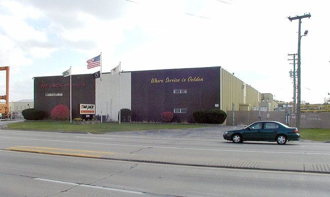
Property Record
3021 W 167Th St, Hazel Crest, IL 60429

NEARBY LISTINGS FOR SALE OR LEASE
Property Detail
3021 W 167Th St
Chicago-Naperville-Elgin, IL-IN-WI
Hazelcrest Farms Sub
28-25-100-020-0000
(CLARKS) RESUB OF LTS 1 & 2 OF HAZELCREST FARMS SUB I N NW NW SEC 25-36-13
Industrialgeneral
Cook
X
Illinois
17031C0729J
1,2
2023
1.86 AC
2024
Near South Cook
825503
Chicago
DEMOGRAPHICS near 3021 W 167Th St
1 Mile
3 Mile
5 Mile
2024 Total Population
11,151
90,445
224,493
2029 Population
10,968
88,986
220,583
Pop Growth 2024-2029
(1.64%)
(1.61%)
(1.74%)
Average Age
39
40
41
2024 Total Households
3,713
31,817
81,950
HH Growth 2024-2029
(1.91%)
(1.89%)
(2.03%)
Median Household Inc
$47,412
$56,637
$63,783
Avg Household Size
2.80
2.70
2.60
2024 Avg HH Vehicles
2.00
2.00
2.00
Median Home Value
$127,982
$153,630
$170,150
Median Year Built
1963
1966
1967
Nearby Places
Map Layers
Map Styles
 Street
 Aerial
- Restaurants
- Banks
- Shops
- Fitness
- Groceries
PUBLIC TRANSPORTATION
COMMUTER RAIL
Hazel Crest Station (Metra Electric Line - Northeast Illinois Regional Commuter Railroad (Metra))
DRIVE
WALK
Distance
Hazel Crest Station (Metra Electric Line - Northeast Illinois Regional Commuter Railroad (Metra))
4 min
2.1 mi
Calumet Station (Metra Electric Line - Northeast Illinois Regional Commuter Railroad (Metra))
DRIVE
WALK
Distance
Calumet Station (Metra Electric Line - Northeast Illinois Regional Commuter Railroad (Metra))
4 min
2.4 mi
AIRPORT
Chicago Midway International
DRIVE
WALK
Distance
Chicago Midway International
28 min
17.1 mi
Chicago O'Hare International
DRIVE
WALK
Distance
Chicago O'Hare International
53 min
38.8 mi
Freight Ports
Port Milwaukee
DRIVE
WALK
Distance
Port Milwaukee
135 min
110.6 mi
Nearby Properties
Address
Land Use
TOTAL SIZE
Lot Size
Zoning
Address
Land Use
TOTAL SIZE
Lot Size
Zoning
1.45 AC
Address
Land Use
TOTAL SIZE
Lot Size
Zoning
Address
Land Use
TOTAL SIZE
Lot Size
Zoning
Address
Land Use
TOTAL SIZE
Lot Size
Zoning
4.85 AC
Address
Land Use
TOTAL SIZE
Lot Size
Zoning
Address
Land Use
TOTAL SIZE
Lot Size
Zoning
203,995 SF
20.27 AC
Address
Land Use
TOTAL SIZE
Lot Size
Zoning
196,125 SF
18.55 AC
Address
Land Use
TOTAL SIZE
Lot Size
Zoning
2.86 AC
Address
Land Use
TOTAL SIZE
Lot Size
Zoning
6.19 AC
Address
Land Use
TOTAL SIZE
Lot Size
Zoning
Address
Land Use
TOTAL SIZE
Lot Size
Zoning
Address
Land Use
TOTAL SIZE
Lot Size
Zoning
27,082 SF
0.69 AC
Address
Land Use
TOTAL SIZE
Lot Size
Zoning
52,220 SF
6 AC
Address
Land Use
TOTAL SIZE
Lot Size
Zoning
49,229 SF
1.31 AC
Address
Land Use
TOTAL SIZE
Lot Size
Zoning
62,380 SF
4.65 AC
Address
Land Use
TOTAL SIZE
Lot Size
Zoning
111,902 SF
8.60 AC
Address
Land Use
TOTAL SIZE
Lot Size
Zoning
6.34 AC
Address
Land Use
TOTAL SIZE
Lot Size
Zoning
15,150 SF
1.64 AC
Address
Land Use
TOTAL SIZE
Lot Size
Zoning
0.34 AC
Address
Land Use
TOTAL SIZE
Lot Size
Zoning
20,579 SF
1.14 AC
Address
Land Use
TOTAL SIZE
Lot Size
Zoning
48,727 SF
3.76 AC
Address
Land Use
TOTAL SIZE
Lot Size
Zoning
5.42 AC
Address
Land Use
TOTAL SIZE
Lot Size
Zoning
185,463 SF
10.96 AC
Address
Land Use
TOTAL SIZE
Lot Size
Zoning
Address
Land Use
TOTAL SIZE
Lot Size
Zoning
Address
Land Use
TOTAL SIZE
Lot Size
Zoning
66,320 SF
12.11 AC
Address
Land Use
TOTAL SIZE
Lot Size
Zoning
90,220 SF
2.21 AC
Address
Land Use
TOTAL SIZE
Lot Size
Zoning
78,075 SF
5.47 AC
Address
Land Use
TOTAL SIZE
Lot Size
Zoning
36,920 SF
14.86 AC
The World's #1 Commercial Real Estate Marketplace
Connect with us
© 2025 CoStar Group
The information above has been obtained from sources believed reliable. While we do not doubt its accuracy we have not verified it and make no guarantee, warranty or representation about it. It is your responsibility to independently confirm its accuracy and completeness. Any projections, opinions, assumptions, or estimates used are for example only and do not represent the current or future performance of the property. The value of this transaction to you depends on tax and other factors which should be evaluated by your tax, financial, and legal advisors. You and your advisors should conduct a careful, independent investigation of the property to determine to your satisfaction the suitability of the property for your needs.