Property Record
3022 E Houston St, San Antonio, TX 78219
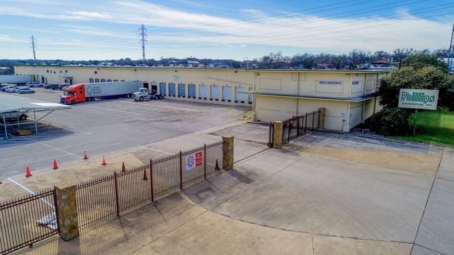

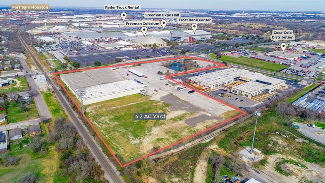
Property Detail
3022 E Houston St
San Antonio-New Braunfels, TX
NCB 10233 BLK LOT 14 (11.355 AC) & W IRR 26.64 FT OF S IRR 548.07 FT OF 15 (0.059 AC) (STAR FOOD SUBD) 2019 SPLIT/MERGE PER DEED 20180095816
10233-000-0140
BEXAR
Officebuilding
Texas
B and X Area of moderate flood hazard, usually the area between the limits of the 100-year and 500-year floods.
14
2024
11.41 AC
2025
Northeast
131504
San Antonio
167,573 SF
NEARBY LISTINGS FOR SALE OR LEASE
DEMOGRAPHICS near 3022 E Houston St
1 mile
3 mile
5 mile
2025 Total Population
12,816
101,800
287,507
2030 Population
13,806
109,010
305,230
Pop Growth 2025-2030
+ 7.72%
+ 7.08%
+ 6.16%
Average Age
35
37
38
2025 Total Households
4,336
37,544
107,625
HH Growth 2025-2030
+ 7.86%
+ 7.45%
+ 6.47%
Median Household Inc
$32,366
$49,738
$52,180
Avg Household Size
2.80
2.50
2.50
2025 Avg HH Vehicles
2.00
2.00
2.00
Median Home Value
$123,805
$193,834
$209,296
Median Year Built
1958
1965
1964
Nearby Places
Map Layers
Map Styles
 Street
 Aerial
Layers
 Traffic
 Biking
Places
Listings with unknown addresses are not visible on the map
- Restaurants
- Banks
- Shops
- Fitness
- Groceries
PUBLIC TRANSPORTATION
COMMUTER RAIL
San Antonio Amtrak Station (Sunset Limited - Amtrak, Texas Eagle - Amtrak)
Drive
Walk
Distance
San Antonio Amtrak Station (Sunset Limited - Amtrak, Texas Eagle - Amtrak)
6 min
2.8 mi
AIRPORT
San Antonio International
Drive
Walk
Distance
San Antonio International
15 min
9.9 mi
Freight Ports
Calhoun Port
Drive
Walk
Distance
Calhoun Port
176 min
144.2 mi
SALE & LEASE HISTORY
LISTING DATE
SALE/LEASE

Sep 12, 2019
For Lease
Mar 22, 2023
For Lease
Feb 16, 2024
For Lease
Nearby Properties
Address
Land Use
TOTAL SIZE
Lot Size
Zoning
Address
Land Use
TOTAL SIZE
Lot Size
Zoning
2,544.56 AC
Address
Land Use
TOTAL SIZE
Lot Size
Zoning
26.51 AC
Address
Land Use
TOTAL SIZE
Lot Size
Zoning
443,000 SF
4.16 AC
Address
Land Use
TOTAL SIZE
Lot Size
Zoning
738,650 SF
2.93 AC
Address
Land Use
TOTAL SIZE
Lot Size
Zoning
1,049,861 SF
1.50 AC
Address
Land Use
TOTAL SIZE
Lot Size
Zoning
339,590 SF
3.12 AC
Address
Land Use
TOTAL SIZE
Lot Size
Zoning
922,468 SF
10.78 AC
Address
Land Use
TOTAL SIZE
Lot Size
Zoning
400,228 SF
0.78 AC
Address
Land Use
TOTAL SIZE
Lot Size
Zoning
290,794 SF
0.62 AC
Address
Land Use
TOTAL SIZE
Lot Size
Zoning
8.10 AC
Address
Land Use
TOTAL SIZE
Lot Size
Zoning
5,106 SF
2.30 AC
Address
Land Use
TOTAL SIZE
Lot Size
Zoning
387,443 SF
0.89 AC
Address
Land Use
TOTAL SIZE
Lot Size
Zoning
43,834 SF
3.11 AC
Address
Land Use
TOTAL SIZE
Lot Size
Zoning
178,534 SF
1.32 AC
Address
Land Use
TOTAL SIZE
Lot Size
Zoning
254,108 SF
2.40 AC
Address
Land Use
TOTAL SIZE
Lot Size
Zoning
103,425 SF
4.76 AC
Address
Land Use
TOTAL SIZE
Lot Size
Zoning
495,840 SF
1.20 AC
Address
Land Use
TOTAL SIZE
Lot Size
Zoning
254,908 SF
1.92 AC
Address
Land Use
TOTAL SIZE
Lot Size
Zoning
11,915 SF
4.06 AC
Address
Land Use
TOTAL SIZE
Lot Size
Zoning
221,865 SF
3.12 AC
Address
Land Use
TOTAL SIZE
Lot Size
Zoning
262,082 SF
1.60 AC
Address
Land Use
TOTAL SIZE
Lot Size
Zoning
163,858 SF
0.62 AC
Address
Land Use
TOTAL SIZE
Lot Size
Zoning
481,589 SF
5.29 AC
Address
Land Use
TOTAL SIZE
Lot Size
Zoning
303,199 SF
9.88 AC
Address
Land Use
TOTAL SIZE
Lot Size
Zoning
161,652 SF
1.79 AC
Address
Land Use
TOTAL SIZE
Lot Size
Zoning
349,678 SF
0.83 AC
Address
Land Use
TOTAL SIZE
Lot Size
Zoning
240,394 SF
0.64 AC
Address
Land Use
TOTAL SIZE
Lot Size
Zoning
4,075 SF
2.80 AC
Address
Land Use
TOTAL SIZE
Lot Size
Zoning
9,390 SF
3.71 AC
Address
Land Use
TOTAL SIZE
Lot Size
Zoning
219,419 SF
2.59 AC
The World's #1 Commercial Real Estate Marketplace
Connect with us
© 2026 CoStar Group
The information above has been obtained from sources believed reliable. While we do not doubt its accuracy we have not verified it and make no guarantee, warranty or representation about it. It is your responsibility to independently confirm its accuracy and completeness. Any projections, opinions, assumptions, or estimates used are for example only and do not represent the current or future performance of the property. The value of this transaction to you depends on tax and other factors which should be evaluated by your tax, financial, and legal advisors. You and your advisors should conduct a careful, independent investigation of the property to determine to your satisfaction the suitability of the property for your needs.