Property Record
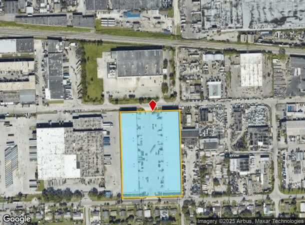
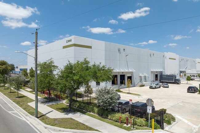
3022 Nw 73Rd St, Miami, FL 33147

NEARBY LISTINGS FOR SALE OR LEASE
Property Detail
3022 Nw 73Rd St
30-3109-000-0840
Vf Commercial
Warehouse
VF COMMERCIAL TRACT PB 177-043 T-24383 TR A LOT SIZE 253554 SQ FT M/L FAU 30-3109-000-0840
AH
Miami/Dade
12086C0303L
Florida
2024
5.82 AC
2025
Hialeah
000903
South Florida
132,358 SF
Miami-Miami Beach-Kendall, FL
DEMOGRAPHICS near 3022 Nw 73Rd St
1 Mile
3 Mile
5 Mile
2024 Total Population
14,443
201,070
540,236
2029 Population
14,401
197,412
533,829
Pop Growth 2024-2029
(0.29%)
(1.82%)
(1.19%)
Average Age
39
42
42
2024 Total Households
4,685
67,494
194,023
HH Growth 2024-2029
(0.55%)
(2.18%)
(1.33%)
Median Household Inc
$42,564
$47,362
$54,627
Avg Household Size
2.90
2.80
2.60
2024 Avg HH Vehicles
2.00
1.00
1.00
Median Home Value
$344,429
$410,036
$447,150
Median Year Built
1960
1961
1967
Nearby Places
Map Layers
Map Styles
 Street
 Aerial
- Restaurants
- Banks
- Shops
- Fitness
- Groceries
PUBLIC TRANSPORTATION
COMMUTER RAIL
Northside (Metrorail Green Line - Miami-Dade Transit (Metrorail/Metromover))
DRIVE
WALK
Distance
Northside (Metrorail Green Line - Miami-Dade Transit (Metrorail/Metromover))
1 min
12 min
0.7 mi
Dr. Martin Luther King Jr. Plaza (Metrorail Green Line - Miami-Dade Transit (Metrorail/Metromover))
DRIVE
WALK
Distance
Dr. Martin Luther King Jr. Plaza (Metrorail Green Line - Miami-Dade Transit (Metrorail/Metromover))
2 min
15 min
0.8 mi
AIRPORT
Miami International
DRIVE
WALK
Distance
Miami International
19 min
7.7 mi
Fort Lauderdale/Hollywood International
DRIVE
WALK
Distance
Fort Lauderdale/Hollywood International
32 min
20.7 mi
Freight Ports
Port of Miami
DRIVE
WALK
Distance
Port of Miami
19 min
9.3 mi
Nearby Properties
Address
Land Use
TOTAL SIZE
Lot Size
Zoning
Address
Land Use
TOTAL SIZE
Lot Size
Zoning
16.13 AC
6100
Address
Land Use
TOTAL SIZE
Lot Size
Zoning
256,089 SF
20.35 AC
7600
Address
Land Use
TOTAL SIZE
Lot Size
Zoning
7.62 AC
7200
Address
Land Use
TOTAL SIZE
Lot Size
Zoning
1,700 SF
7.24 AC
7100
Address
Land Use
TOTAL SIZE
Lot Size
Zoning
970,804 SF
46.92 AC
7100
Address
Land Use
TOTAL SIZE
Lot Size
Zoning
451,817 SF
6400
Address
Land Use
TOTAL SIZE
Lot Size
Zoning
803,285 SF
63.32 AC
7100
Address
Land Use
TOTAL SIZE
Lot Size
Zoning
603,504 SF
27.15 AC
7100
Address
Land Use
TOTAL SIZE
Lot Size
Zoning
393,093 SF
3.61 AC
6400
Address
Land Use
TOTAL SIZE
Lot Size
Zoning
239,869 SF
5 AC
8000
Address
Land Use
TOTAL SIZE
Lot Size
Zoning
207,475 SF
51.47 AC
7100
Address
Land Use
TOTAL SIZE
Lot Size
Zoning
363,010 SF
19.13 AC
8000
Address
Land Use
TOTAL SIZE
Lot Size
Zoning
73,727 SF
232.58 AC
8054
Address
Land Use
TOTAL SIZE
Lot Size
Zoning
510,373 SF
154.10 AC
8900
Address
Land Use
TOTAL SIZE
Lot Size
Zoning
530,479 SF
10.13 AC
6400
Address
Land Use
TOTAL SIZE
Lot Size
Zoning
680,945 SF
35.56 AC
6400
Address
Land Use
TOTAL SIZE
Lot Size
Zoning
569,763 SF
31.75 AC
3900
Address
Land Use
TOTAL SIZE
Lot Size
Zoning
281,761 SF
26.88 AC
7100
Address
Land Use
TOTAL SIZE
Lot Size
Zoning
366,063 SF
57.35 AC
7100
Address
Land Use
TOTAL SIZE
Lot Size
Zoning
412,149 SF
19.40 AC
7100
Address
Land Use
TOTAL SIZE
Lot Size
Zoning
197,181 SF
7.95 AC
6062
Address
Land Use
TOTAL SIZE
Lot Size
Zoning
304,073 SF
6 AC
6200
Address
Land Use
TOTAL SIZE
Lot Size
Zoning
504,970 SF
29.65 AC
5000
Address
Land Use
TOTAL SIZE
Lot Size
Zoning
485,478 SF
18.10 AC
7100
Address
Land Use
TOTAL SIZE
Lot Size
Zoning
565,961 SF
17.98 AC
7300
Address
Land Use
TOTAL SIZE
Lot Size
Zoning
219,849 SF
3.72 AC
8000
Address
Land Use
TOTAL SIZE
Lot Size
Zoning
283,103 SF
18.68 AC
7100
Address
Land Use
TOTAL SIZE
Lot Size
Zoning
35,881 SF
7.75 AC
6118
Address
Land Use
TOTAL SIZE
Lot Size
Zoning
232,213 SF
7.96 AC
6062
Address
Land Use
TOTAL SIZE
Lot Size
Zoning
316,595 SF
10.50 AC
7100
The World's #1 Commercial Real Estate Marketplace
Connect with us
© 2025 CoStar Group
The information above has been obtained from sources believed reliable. While we do not doubt its accuracy we have not verified it and make no guarantee, warranty or representation about it. It is your responsibility to independently confirm its accuracy and completeness. Any projections, opinions, assumptions, or estimates used are for example only and do not represent the current or future performance of the property. The value of this transaction to you depends on tax and other factors which should be evaluated by your tax, financial, and legal advisors. You and your advisors should conduct a careful, independent investigation of the property to determine to your satisfaction the suitability of the property for your needs.