Property Record
3023 E 29Th St, Des Moines, IA 50317
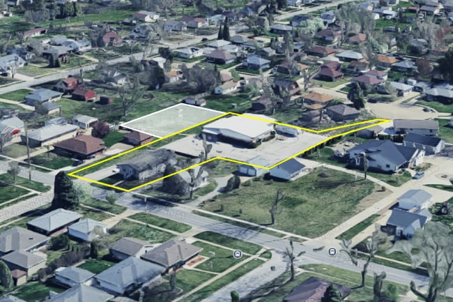
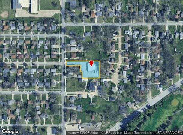
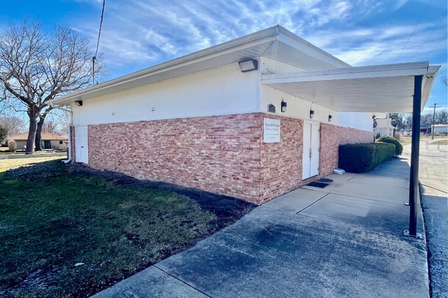
This Property Is For Sale
NEARBY LISTINGS FOR SALE OR LEASE
Property Detail
3023 E 29Th St
Des Moines-West Des Moines, IA
Holts Addition
060-06243007000
PARCEL 2022-1152 BK 19246 PG 395 LOT 6 HOLTS ADDITION
Religious
Polk
X
Iowa
19153C0360F
6
0
0.85 AC
2025
Northeast
000103
Des Moines
4,282 SF
DEMOGRAPHICS near 3023 E 29Th St
1 Mile
3 Mile
5 Mile
2024 Total Population
9,090
62,615
144,360
2029 Population
9,754
67,735
157,757
Pop Growth 2024-2029
+ 7.30%
+ 8.18%
+ 9.28%
Average Age
41
39
38
2024 Total Households
3,792
23,806
57,885
HH Growth 2024-2029
+ 7.54%
+ 8.47%
+ 9.76%
Median Household Inc
$62,519
$56,754
$57,352
Avg Household Size
2.30
2.50
2.30
2024 Avg HH Vehicles
2.00
2.00
2.00
Median Home Value
$152,834
$142,798
$158,797
Median Year Built
1958
1958
1971
Nearby Places
Map Layers
Map Styles
 Street
 Aerial
- Restaurants
- Banks
- Shops
- Fitness
- Groceries
PUBLIC TRANSPORTATION
AIRPORT
Des Moines International
DRIVE
WALK
Distance
Des Moines International
21 min
10.2 mi
Nearby Properties
Address
Land Use
TOTAL SIZE
Lot Size
Zoning
Address
Land Use
TOTAL SIZE
Lot Size
Zoning
428,582 SF
6.87 AC
C-0
Address
Land Use
TOTAL SIZE
Lot Size
Zoning
481,030 SF
31.92 AC
PUD
Address
Land Use
TOTAL SIZE
Lot Size
Zoning
675,000 SF
65.27 AC
Address
Land Use
TOTAL SIZE
Lot Size
Zoning
177,094 SF
24.60 AC
Address
Land Use
TOTAL SIZE
Lot Size
Zoning
312,500 SF
38.14 AC
Address
Land Use
TOTAL SIZE
Lot Size
Zoning
320,429 SF
22.34 AC
R3
Address
Land Use
TOTAL SIZE
Lot Size
Zoning
529,161 SF
33.60 AC
HI
Address
Land Use
TOTAL SIZE
Lot Size
Zoning
126,935 SF
28.61 AC
Address
Land Use
TOTAL SIZE
Lot Size
Zoning
603,502 SF
33.03 AC
M-1
Address
Land Use
TOTAL SIZE
Lot Size
Zoning
90,325 SF
5.49 AC
PUD
Address
Land Use
TOTAL SIZE
Lot Size
Zoning
82,202 SF
9.48 AC
PUD
Address
Land Use
TOTAL SIZE
Lot Size
Zoning
184,320 SF
9.68 AC
Address
Land Use
TOTAL SIZE
Lot Size
Zoning
218,593 SF
19.31 AC
M-2
Address
Land Use
TOTAL SIZE
Lot Size
Zoning
162,240 SF
9.19 AC
Address
Land Use
TOTAL SIZE
Lot Size
Zoning
79,991 SF
4.55 AC
M-1
Address
Land Use
TOTAL SIZE
Lot Size
Zoning
1,890,511 SF
39.03 AC
M-2
Address
Land Use
TOTAL SIZE
Lot Size
Zoning
274,160 SF
19.99 AC
M-1
Address
Land Use
TOTAL SIZE
Lot Size
Zoning
155,276 SF
6.66 AC
R-4
Address
Land Use
TOTAL SIZE
Lot Size
Zoning
181,492 SF
12.32 AC
M1
Address
Land Use
TOTAL SIZE
Lot Size
Zoning
79,823 SF
11.47 AC
M2
Address
Land Use
TOTAL SIZE
Lot Size
Zoning
198,500 SF
11.79 AC
M-1
Address
Land Use
TOTAL SIZE
Lot Size
Zoning
71,666 SF
18.40 AC
R1-80
Address
Land Use
TOTAL SIZE
Lot Size
Zoning
199,180 SF
9.64 AC
M-1
Address
Land Use
TOTAL SIZE
Lot Size
Zoning
83,885 SF
1.57 AC
PUD
Address
Land Use
TOTAL SIZE
Lot Size
Zoning
61,030 SF
3.37 AC
Address
Land Use
TOTAL SIZE
Lot Size
Zoning
127,200 SF
12.31 AC
HI
Address
Land Use
TOTAL SIZE
Lot Size
Zoning
76,524 SF
3.17 AC
C-2
Address
Land Use
TOTAL SIZE
Lot Size
Zoning
87,000 SF
4.20 AC
C-0
Address
Land Use
TOTAL SIZE
Lot Size
Zoning
90,096 SF
12.96 AC
Address
Land Use
TOTAL SIZE
Lot Size
Zoning
548,272 SF
24.53 AC
HI
The World's #1 Commercial Real Estate Marketplace
Connect with us
© 2025 CoStar Group
The information above has been obtained from sources believed reliable. While we do not doubt its accuracy we have not verified it and make no guarantee, warranty or representation about it. It is your responsibility to independently confirm its accuracy and completeness. Any projections, opinions, assumptions, or estimates used are for example only and do not represent the current or future performance of the property. The value of this transaction to you depends on tax and other factors which should be evaluated by your tax, financial, and legal advisors. You and your advisors should conduct a careful, independent investigation of the property to determine to your satisfaction the suitability of the property for your needs.