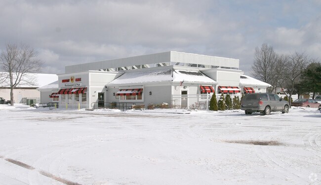
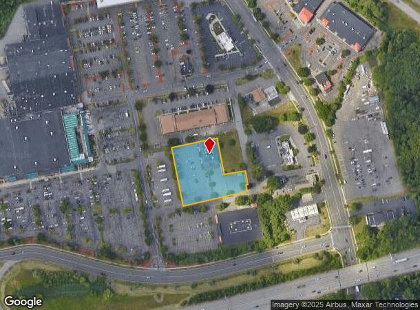
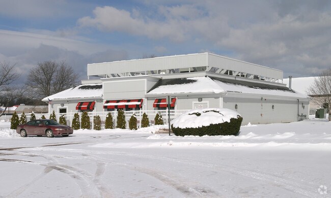
Property Record
3025 Main St, Glastonbury, CT 06033
NEARBY LISTINGS FOR SALE OR LEASE
Property Detail
3025 Main St
GLAS-000004C-004140-W000002B
Hartford
Commercialbuilding
Connecticut
X
w0002b
09003C0526F
1.30 AC
2025
Glastonbury
2025
Hartford
520302
Hartford-West Hartford-East Hartford, CT
6,415 SF
DEMOGRAPHICS near 3025 Main St
1 Mile
3 Mile
5 Mile
2024 Total Population
7,705
50,614
194,864
2029 Population
7,646
50,347
194,235
Pop Growth 2024-2029
(0.77%)
(0.53%)
(0.32%)
Average Age
42
41
39
2024 Total Households
3,324
21,003
78,207
HH Growth 2024-2029
(0.84%)
(0.57%)
(0.21%)
Median Household Inc
$78,703
$79,899
$65,037
Avg Household Size
2.30
2.40
2.40
2024 Avg HH Vehicles
2.00
2.00
2.00
Median Home Value
$180,960
$238,864
$246,031
Median Year Built
1964
1962
1961
Nearby Places
Map Layers
Map Styles
 Street
 Aerial
- Restaurants
- Banks
- Shops
- Fitness
- Groceries
PUBLIC TRANSPORTATION
COMMUTER RAIL
DRIVE
WALK
Distance
11 min
5.4 mi
DRIVE
WALK
Distance
11 min
5.4 mi
AIRPORT
Bradley International
DRIVE
WALK
Distance
Bradley International
33 min
19.2 mi
Tweed/New Haven
DRIVE
WALK
Distance
Tweed/New Haven
55 min
38.2 mi
Freight Ports
Port of New Haven
DRIVE
WALK
Distance
Port of New Haven
49 min
37.0 mi
Nearby Properties
Address
Land Use
TOTAL SIZE
Lot Size
Zoning
Address
Land Use
TOTAL SIZE
Lot Size
Zoning
149.23 AC
DDD1
Address
Land Use
TOTAL SIZE
Lot Size
Zoning
112.42 AC
DDD1
Address
Land Use
TOTAL SIZE
Lot Size
Zoning
69.42 AC
CT R
Address
Land Use
TOTAL SIZE
Lot Size
Zoning
2,500 SF
74.98 AC
I-2
Address
Land Use
TOTAL SIZE
Lot Size
Zoning
9.92 AC
DDD1
Address
Land Use
TOTAL SIZE
Lot Size
Zoning
49,219 SF
31.72 AC
Address
Land Use
TOTAL SIZE
Lot Size
Zoning
235,476 SF
198.32 AC
CT R
Address
Land Use
TOTAL SIZE
Lot Size
Zoning
109,276 SF
11 AC
DDD1
Address
Land Use
TOTAL SIZE
Lot Size
Zoning
36.69 AC
R-5
Address
Land Use
TOTAL SIZE
Lot Size
Zoning
55.64 AC
Address
Land Use
TOTAL SIZE
Lot Size
Zoning
348,943 SF
51.21 AC
R-2
Address
Land Use
TOTAL SIZE
Lot Size
Zoning
160,936 SF
2.40 AC
CX-1
Address
Land Use
TOTAL SIZE
Lot Size
Zoning
81,313 SF
4.44 AC
R-3
Address
Land Use
TOTAL SIZE
Lot Size
Zoning
188,454 SF
178.60 AC
A
Address
Land Use
TOTAL SIZE
Lot Size
Zoning
7.07 AC
PBD
Address
Land Use
TOTAL SIZE
Lot Size
Zoning
116,979 SF
17 AC
B
Address
Land Use
TOTAL SIZE
Lot Size
Zoning
18.26 AC
R-5
Address
Land Use
TOTAL SIZE
Lot Size
Zoning
129,065 SF
4.63 AC
MX-2
Address
Land Use
TOTAL SIZE
Lot Size
Zoning
Address
Land Use
TOTAL SIZE
Lot Size
Zoning
126,934 SF
1.51 AC
B-4
Address
Land Use
TOTAL SIZE
Lot Size
Zoning
11.95 AC
PAD
Address
Land Use
TOTAL SIZE
Lot Size
Zoning
15.12 AC
PAD
Address
Land Use
TOTAL SIZE
Lot Size
Zoning
Address
Land Use
TOTAL SIZE
Lot Size
Zoning
8.14 AC
Address
Land Use
TOTAL SIZE
Lot Size
Zoning
181,421 SF
18.36 AC
DDD1
Address
Land Use
TOTAL SIZE
Lot Size
Zoning
20.36 AC
B-1
Address
Land Use
TOTAL SIZE
Lot Size
Zoning
33.19 AC
ID-1
Address
Land Use
TOTAL SIZE
Lot Size
Zoning
158,692 SF
2.89 AC
PAD
Address
Land Use
TOTAL SIZE
Lot Size
Zoning
105,294 SF
2.49 AC
PAD
Address
Land Use
TOTAL SIZE
Lot Size
Zoning
7.90 AC
The World's #1 Commercial Real Estate Marketplace
Connect with us
© 2025 CoStar Group
The information above has been obtained from sources believed reliable. While we do not doubt its accuracy we have not verified it and make no guarantee, warranty or representation about it. It is your responsibility to independently confirm its accuracy and completeness. Any projections, opinions, assumptions, or estimates used are for example only and do not represent the current or future performance of the property. The value of this transaction to you depends on tax and other factors which should be evaluated by your tax, financial, and legal advisors. You and your advisors should conduct a careful, independent investigation of the property to determine to your satisfaction the suitability of the property for your needs.