Property Record
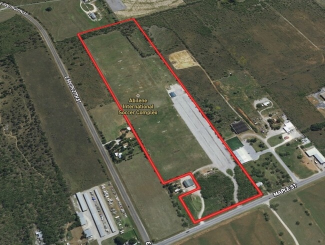
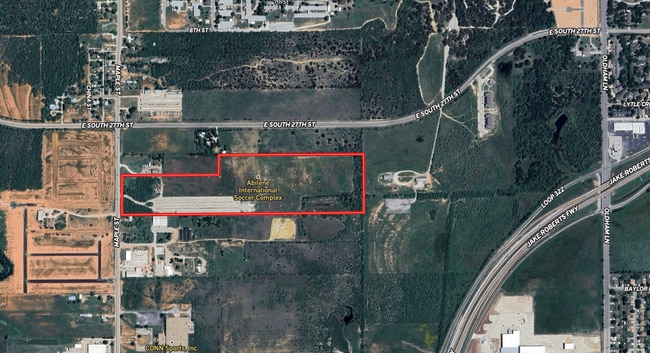
3025 Maple St, Abilene, TX 79602


Property Detail
3025 Maple St
Abilene, TX
STEELE ADDITION SEC 2, BLOCK A, LOT 102 REP, ACRES 32.07
969057
TAYLOR
Multipleuses
Texas
B and X Area of moderate flood hazard, usually the area between the limits of the 100-year and 500-year floods.
102
2024
32.07 AC
2025
Abilene
012000
Other Market Areas
2,400 SF
NEARBY LISTINGS FOR SALE OR LEASE
DEMOGRAPHICS near 3025 Maple St
1 mile
3 mile
5 mile
2025 Total Population
1,927
38,736
102,674
2030 Population
2,031
40,048
106,125
Pop Growth 2025-2030
+ 5.40%
+ 3.39%
+ 3.36%
Average Age
41
38
37
2025 Total Households
529
15,284
39,900
HH Growth 2025-2030
+ 5.10%
+ 3.49%
+ 3.49%
Median Household Inc
$89,722
$66,889
$59,787
Avg Household Size
2.40
2.40
2.40
2025 Avg HH Vehicles
2.00
2.00
2.00
Median Home Value
$222,400
$198,539
$192,904
Median Year Built
1988
1972
1972
Nearby Places
Map Layers
Map Styles
 Street
 Aerial
Layers
 Traffic
 Biking
Places
Listings with unknown addresses are not visible on the map
- Restaurants
- Banks
- Shops
- Fitness
- Groceries
PUBLIC TRANSPORTATION
AIRPORT
Abilene Regional
Drive
Walk
Distance
Abilene Regional
12 min
5.3 mi
Freight Ports
Calhoun Port
Drive
Walk
Distance
Calhoun Port
436 min
373.0 mi
Nearby Properties
Address
Land Use
TOTAL SIZE
Lot Size
Zoning
Address
Land Use
TOTAL SIZE
Lot Size
Zoning
241,730 SF
51.89 AC
Address
Land Use
TOTAL SIZE
Lot Size
Zoning
283,878 SF
76.01 AC
Address
Land Use
TOTAL SIZE
Lot Size
Zoning
600,001 SF
39.40 AC
Address
Land Use
TOTAL SIZE
Lot Size
Zoning
411,104 SF
91.21 AC
Address
Land Use
TOTAL SIZE
Lot Size
Zoning
256,877 SF
11.04 AC
Address
Land Use
TOTAL SIZE
Lot Size
Zoning
117,390 SF
28.79 AC
Address
Land Use
TOTAL SIZE
Lot Size
Zoning
129,462 SF
69.58 AC
Address
Land Use
TOTAL SIZE
Lot Size
Zoning
115,568 SF
23.57 AC
Address
Land Use
TOTAL SIZE
Lot Size
Zoning
421,730 SF
30.12 AC
Address
Land Use
TOTAL SIZE
Lot Size
Zoning
114,617 SF
23.73 AC
Address
Land Use
TOTAL SIZE
Lot Size
Zoning
180,936 SF
31.23 AC
Address
Land Use
TOTAL SIZE
Lot Size
Zoning
92,427 SF
21.52 AC
Address
Land Use
TOTAL SIZE
Lot Size
Zoning
143,845 SF
11.47 AC
Address
Land Use
TOTAL SIZE
Lot Size
Zoning
58,988 SF
1,463.70 AC
Address
Land Use
TOTAL SIZE
Lot Size
Zoning
620,165 SF
107.40 AC
Address
Land Use
TOTAL SIZE
Lot Size
Zoning
166,224 SF
8.79 AC
Address
Land Use
TOTAL SIZE
Lot Size
Zoning
70,076 SF
24.79 AC
Address
Land Use
TOTAL SIZE
Lot Size
Zoning
195,960 SF
11.07 AC
Address
Land Use
TOTAL SIZE
Lot Size
Zoning
187,944 SF
8.69 AC
Address
Land Use
TOTAL SIZE
Lot Size
Zoning
200,648 SF
8.98 AC
Address
Land Use
TOTAL SIZE
Lot Size
Zoning
71,515 SF
9.94 AC
Address
Land Use
TOTAL SIZE
Lot Size
Zoning
84,335 SF
4.68 AC
Address
Land Use
TOTAL SIZE
Lot Size
Zoning
79,879 SF
2.86 AC
Address
Land Use
TOTAL SIZE
Lot Size
Zoning
67,593 SF
49.82 AC
Address
Land Use
TOTAL SIZE
Lot Size
Zoning
80,574 SF
4.20 AC
Address
Land Use
TOTAL SIZE
Lot Size
Zoning
101,812 SF
6.28 AC
Address
Land Use
TOTAL SIZE
Lot Size
Zoning
146,819 SF
9.75 AC
Address
Land Use
TOTAL SIZE
Lot Size
Zoning
4,500 SF
18.85 AC
Address
Land Use
TOTAL SIZE
Lot Size
Zoning
138,432 SF
7.06 AC
Address
Land Use
TOTAL SIZE
Lot Size
Zoning
54,844 SF
12.70 AC
The World's #1 Commercial Real Estate Marketplace
Connect with us
© 2026 CoStar Group
The information above has been obtained from sources believed reliable. While we do not doubt its accuracy we have not verified it and make no guarantee, warranty or representation about it. It is your responsibility to independently confirm its accuracy and completeness. Any projections, opinions, assumptions, or estimates used are for example only and do not represent the current or future performance of the property. The value of this transaction to you depends on tax and other factors which should be evaluated by your tax, financial, and legal advisors. You and your advisors should conduct a careful, independent investigation of the property to determine to your satisfaction the suitability of the property for your needs.