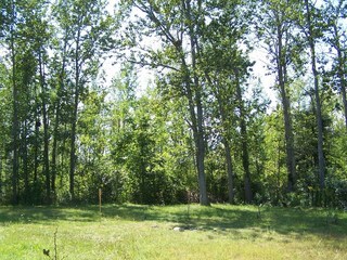
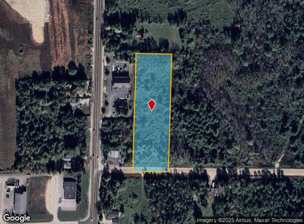
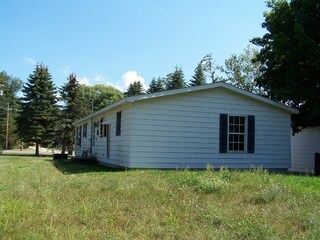
Property Record
1039 Vanderlip Rd, Traverse City, MI 49686
NEARBY LISTINGS FOR SALE OR LEASE
Property Detail
1039 Vanderlip Rd
Traverse City, MI
Th Pob Sub
03-220-030-30
PART OF TH NW 1/4 SEC 20 T27N R10W COMM W 1/4 COR TH S 88 DEG 39'40'' E 200' TO POB TH S 88 DEG 39'4
Residentialacreage
Grand Traverse
X
Michigan
26055C0231D
3 AC
2024
Michigan Northwest Area
2025
Other Market Areas
551100
DEMOGRAPHICS near 1039 Vanderlip Rd
1 Mile
3 Mile
5 Mile
2024 Total Population
1,059
17,267
42,147
2029 Population
1,081
17,741
43,560
Pop Growth 2024-2029
+ 2.08%
+ 2.75%
+ 3.35%
Average Age
44
42
44
2024 Total Households
495
7,686
19,015
HH Growth 2024-2029
+ 2.02%
+ 2.71%
+ 3.38%
Median Household Inc
$59,761
$59,683
$62,666
Avg Household Size
2.10
2.20
2.10
2024 Avg HH Vehicles
2.00
2.00
2.00
Median Home Value
$189,936
$226,711
$282,791
Median Year Built
1981
1985
1982
Nearby Places
Map Layers
Map Styles
 Street
 Aerial
- Restaurants
- Banks
- Shops
- Fitness
- Groceries
PUBLIC TRANSPORTATION
AIRPORT
Cherry Capital
DRIVE
WALK
Distance
Cherry Capital
11 min
4.2 mi
Freight Ports
Port Milwaukee
DRIVE
WALK
Distance
Port Milwaukee
457 min
398.8 mi
SALE & LEASE HISTORY
LISTING DATE
SALE/LEASE

Sep 24, 2016
For Sale
Nearby Properties
Address
Land Use
TOTAL SIZE
Lot Size
Zoning
Address
Land Use
TOTAL SIZE
Lot Size
Zoning
81,900 SF
870.88 AC
Address
Land Use
TOTAL SIZE
Lot Size
Zoning
5,308 SF
27.64 AC
Address
Land Use
TOTAL SIZE
Lot Size
Zoning
41,084 SF
22.79 AC
Address
Land Use
TOTAL SIZE
Lot Size
Zoning
189,750 SF
94.80 AC
Address
Land Use
TOTAL SIZE
Lot Size
Zoning
25,208 SF
15.01 AC
Address
Land Use
TOTAL SIZE
Lot Size
Zoning
6,354 SF
97.88 AC
Address
Land Use
TOTAL SIZE
Lot Size
Zoning
40,790 SF
2.31 AC
Address
Land Use
TOTAL SIZE
Lot Size
Zoning
155,000 SF
12.63 AC
Address
Land Use
TOTAL SIZE
Lot Size
Zoning
8,820 SF
15.24 AC
Address
Land Use
TOTAL SIZE
Lot Size
Zoning
720 SF
3.80 AC
Address
Land Use
TOTAL SIZE
Lot Size
Zoning
45,574 SF
21.75 AC
Address
Land Use
TOTAL SIZE
Lot Size
Zoning
78,933 SF
19.79 AC
Address
Land Use
TOTAL SIZE
Lot Size
Zoning
17,892 SF
18.28 AC
Address
Land Use
TOTAL SIZE
Lot Size
Zoning
100,409 SF
32.45 AC
Address
Land Use
TOTAL SIZE
Lot Size
Zoning
43,100 SF
10.29 AC
Address
Land Use
TOTAL SIZE
Lot Size
Zoning
40,900 SF
3.03 AC
Address
Land Use
TOTAL SIZE
Lot Size
Zoning
67,257 SF
3.50 AC
Address
Land Use
TOTAL SIZE
Lot Size
Zoning
65,000 SF
7.04 AC
Address
Land Use
TOTAL SIZE
Lot Size
Zoning
155,882 SF
19.57 AC
Address
Land Use
TOTAL SIZE
Lot Size
Zoning
88,964 SF
0.86 AC
Address
Land Use
TOTAL SIZE
Lot Size
Zoning
91,128 SF
7.09 AC
Address
Land Use
TOTAL SIZE
Lot Size
Zoning
30,233 SF
14.45 AC
Address
Land Use
TOTAL SIZE
Lot Size
Zoning
25,271 SF
3.24 AC
Address
Land Use
TOTAL SIZE
Lot Size
Zoning
27,889 SF
14.55 AC
Address
Land Use
TOTAL SIZE
Lot Size
Zoning
Address
Land Use
TOTAL SIZE
Lot Size
Zoning
9,608 SF
10.99 AC
Address
Land Use
TOTAL SIZE
Lot Size
Zoning
50,096 SF
2.31 AC
Address
Land Use
TOTAL SIZE
Lot Size
Zoning
41,472 SF
1.72 AC
Address
Land Use
TOTAL SIZE
Lot Size
Zoning
40,300 SF
73.06 AC
Address
Land Use
TOTAL SIZE
Lot Size
Zoning
40,539 SF
27 AC
The World's #1 Commercial Real Estate Marketplace
Connect with us
© 2025 CoStar Group
The information above has been obtained from sources believed reliable. While we do not doubt its accuracy we have not verified it and make no guarantee, warranty or representation about it. It is your responsibility to independently confirm its accuracy and completeness. Any projections, opinions, assumptions, or estimates used are for example only and do not represent the current or future performance of the property. The value of this transaction to you depends on tax and other factors which should be evaluated by your tax, financial, and legal advisors. You and your advisors should conduct a careful, independent investigation of the property to determine to your satisfaction the suitability of the property for your needs.