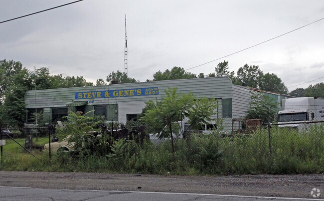
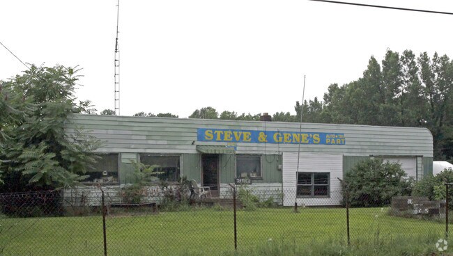
Property Record
3029 S Gertrude St, South Bend, IN 46614
NEARBY LISTINGS FOR SALE OR LEASE
-
-
View all South Bend listings for sale on LoopNet.com
Property Detail
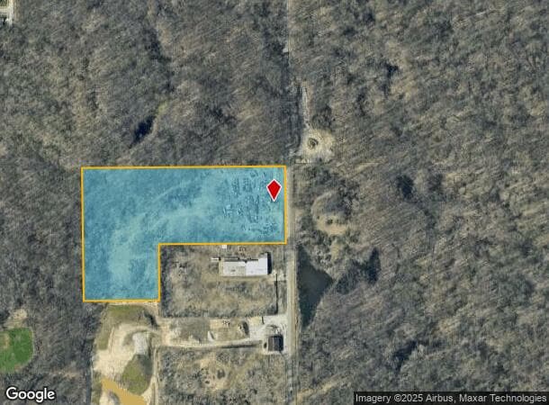
3029 S Gertrude St
71-08-22-400-007.000-026
18.75 ACRES N END E1/2 SE SEC 22-37-2E
Industrialgeneral
St Joseph
X
Indiana
18141C0194D
18.75 AC
2023
Greater South Bend
2024
South Bend/Mishawaka
011804
South Bend-Mishawaka, IN-MI
1,796 SF
DEMOGRAPHICS near 3029 S Gertrude St
1 Mile
3 Mile
5 Mile
2024 Total Population
3,787
57,558
137,093
2029 Population
3,803
57,876
137,686
Pop Growth 2024-2029
+ 0.42%
+ 0.55%
+ 0.43%
Average Age
35
37
37
2024 Total Households
1,401
21,855
52,127
HH Growth 2024-2029
+ 0.36%
+ 0.47%
+ 0.46%
Median Household Inc
$41,585
$44,844
$49,452
Avg Household Size
2.70
2.50
2.40
2024 Avg HH Vehicles
1.00
2.00
2.00
Median Home Value
$70,893
$98,771
$122,444
Median Year Built
1956
1954
1956
Nearby Places
Map Layers
Map Styles
 Street
 Aerial
- Restaurants
- Banks
- Shops
- Fitness
- Groceries
PUBLIC TRANSPORTATION
COMMUTER RAIL
South Bend Amtrak Station (Capitol Limited - Amtrak, Lake Shore Limited - Amtrak)
DRIVE
WALK
Distance
South Bend Amtrak Station (Capitol Limited - Amtrak, Lake Shore Limited - Amtrak)
9 min
3.2 mi
South Bend Airport Station (South Shore Line - Northern Indiana Commuter Transportation District (South Shore Line))
DRIVE
WALK
Distance
South Bend Airport Station (South Shore Line - Northern Indiana Commuter Transportation District (South Shore Line))
14 min
6.2 mi
AIRPORT
South Bend International
DRIVE
WALK
Distance
South Bend International
22 min
8.3 mi
Freight Ports
Port Milwaukee
DRIVE
WALK
Distance
Port Milwaukee
221 min
182.5 mi
Nearby Properties
Address
Land Use
TOTAL SIZE
Lot Size
Zoning
Address
Land Use
TOTAL SIZE
Lot Size
Zoning
291,729 SF
0.79 AC
Address
Land Use
TOTAL SIZE
Lot Size
Zoning
270,484 SF
131 SF
Address
Land Use
TOTAL SIZE
Lot Size
Zoning
158,616 SF
0.85 AC
Address
Land Use
TOTAL SIZE
Lot Size
Zoning
231,450 SF
87 SF
Address
Land Use
TOTAL SIZE
Lot Size
Zoning
194,931 SF
44 SF
Address
Land Use
TOTAL SIZE
Lot Size
Zoning
161,548 SF
44 SF
Address
Land Use
TOTAL SIZE
Lot Size
Zoning
544,872 SF
70.95 AC
Address
Land Use
TOTAL SIZE
Lot Size
Zoning
178,111 SF
44 SF
Address
Land Use
TOTAL SIZE
Lot Size
Zoning
260,370 SF
Address
Land Use
TOTAL SIZE
Lot Size
Zoning
172,368 SF
2.22 AC
Address
Land Use
TOTAL SIZE
Lot Size
Zoning
221,887 SF
87 SF
Address
Land Use
TOTAL SIZE
Lot Size
Zoning
55,995 SF
0.78 AC
Address
Land Use
TOTAL SIZE
Lot Size
Zoning
633,136 SF
2.59 AC
Address
Land Use
TOTAL SIZE
Lot Size
Zoning
165,725 SF
0.01 AC
Address
Land Use
TOTAL SIZE
Lot Size
Zoning
100,368 SF
44 SF
Address
Land Use
TOTAL SIZE
Lot Size
Zoning
138,993 SF
0.38 AC
Address
Land Use
TOTAL SIZE
Lot Size
Zoning
201,264 SF
1.45 AC
Address
Land Use
TOTAL SIZE
Lot Size
Zoning
284,474 SF
7.61 AC
Address
Land Use
TOTAL SIZE
Lot Size
Zoning
89,802 SF
0.68 AC
Address
Land Use
TOTAL SIZE
Lot Size
Zoning
74,976 SF
44 SF
Address
Land Use
TOTAL SIZE
Lot Size
Zoning
94,801 SF
2.70 AC
Address
Land Use
TOTAL SIZE
Lot Size
Zoning
91,091 SF
131 SF
Address
Land Use
TOTAL SIZE
Lot Size
Zoning
136,568 SF
44 SF
Address
Land Use
TOTAL SIZE
Lot Size
Zoning
79,760 SF
13.17 AC
Address
Land Use
TOTAL SIZE
Lot Size
Zoning
84,105 SF
0.22 AC
Address
Land Use
TOTAL SIZE
Lot Size
Zoning
123,359 SF
44 SF
Address
Land Use
TOTAL SIZE
Lot Size
Zoning
87,310 SF
44 SF
Address
Land Use
TOTAL SIZE
Lot Size
Zoning
93,530 SF
8.08 AC
Address
Land Use
TOTAL SIZE
Lot Size
Zoning
58,135 SF
174 SF
Address
Land Use
TOTAL SIZE
Lot Size
Zoning
78,229 SF
0.54 AC
The World's #1 Commercial Real Estate Marketplace
Connect with us
© 2025 CoStar Group
The information above has been obtained from sources believed reliable. While we do not doubt its accuracy we have not verified it and make no guarantee, warranty or representation about it. It is your responsibility to independently confirm its accuracy and completeness. Any projections, opinions, assumptions, or estimates used are for example only and do not represent the current or future performance of the property. The value of this transaction to you depends on tax and other factors which should be evaluated by your tax, financial, and legal advisors. You and your advisors should conduct a careful, independent investigation of the property to determine to your satisfaction the suitability of the property for your needs.