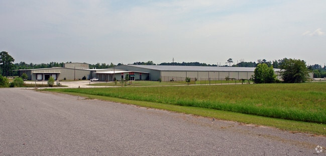
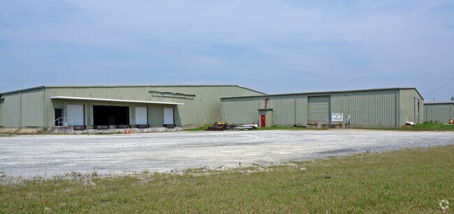
Property Record
303 Bohannon Rd, Kinston, NC 28501

NEARBY LISTINGS FOR SALE OR LEASE
-
-
View all Kinston listings for sale on LoopNet.com
Property Detail
303 Bohannon Rd
453403043504
Union Tobacco And Storage Company
Officebuilding
HWY 70 EAST TRACT 2 303 BOHANNON RD
AE
Lenoir
3720453400K
North Carolina
2025
19.02 AC
2025
Other Market Areas
011400
Kinston, NC
162,825 SF
DEMOGRAPHICS near 303 Bohannon Rd
1 Mile
3 Mile
5 Mile
2024 Total Population
59
11,321
24,413
2029 Population
59
11,539
24,396
Pop Growth 2024-2029
0.00%
+ 1.93%
(0.07%)
Average Age
44
41
42
2024 Total Households
26
5,148
10,580
HH Growth 2024-2029
0.00%
+ 1.90%
(0.04%)
Median Household Inc
$70,714
$26,613
$33,702
Avg Household Size
2.20
2.10
2.20
2024 Avg HH Vehicles
3.00
1.00
2.00
Median Home Value
$139,285
$78,179
$95,454
Median Year Built
1979
1966
1969
Nearby Places
Map Layers
Map Styles
 Street
 Aerial
- Restaurants
- Banks
- Shops
- Fitness
- Groceries
PUBLIC TRANSPORTATION
AIRPORT
Pitt-Greenville
DRIVE
WALK
Distance
Pitt-Greenville
51 min
33.4 mi
Albert J Ellis
DRIVE
WALK
Distance
Albert J Ellis
63 min
35.6 mi
Coastal Carolina Regional
DRIVE
WALK
Distance
Coastal Carolina Regional
46 min
35.8 mi
Freight Ports
Port of Morehead City
DRIVE
WALK
Distance
Port of Morehead City
106 min
73.7 mi
Nearby Properties
Address
Land Use
TOTAL SIZE
Lot Size
Zoning
Address
Land Use
TOTAL SIZE
Lot Size
Zoning
20,042 SF
77.79 AC
O&I
Address
Land Use
TOTAL SIZE
Lot Size
Zoning
144,099 SF
23.48 AC
RA8
Address
Land Use
TOTAL SIZE
Lot Size
Zoning
525,504 SF
76.02 AC
I1
Address
Land Use
TOTAL SIZE
Lot Size
Zoning
77,100 SF
1.91 AC
B2
Address
Land Use
TOTAL SIZE
Lot Size
Zoning
119,634 SF
1.86 AC
B2
Address
Land Use
TOTAL SIZE
Lot Size
Zoning
51,934 SF
0.32 AC
B2
Address
Land Use
TOTAL SIZE
Lot Size
Zoning
73,800 SF
5.38 AC
B1
Address
Land Use
TOTAL SIZE
Lot Size
Zoning
23,086 SF
7.39 AC
RA5
Address
Land Use
TOTAL SIZE
Lot Size
Zoning
6,178 SF
6.33 AC
RA5
Address
Land Use
TOTAL SIZE
Lot Size
Zoning
108,816 SF
1.30 AC
B2
Address
Land Use
TOTAL SIZE
Lot Size
Zoning
13,257 SF
27.42 AC
Address
Land Use
TOTAL SIZE
Lot Size
Zoning
8,640 SF
8.03 AC
RA5
Address
Land Use
TOTAL SIZE
Lot Size
Zoning
83,088 SF
1.19 AC
B2
Address
Land Use
TOTAL SIZE
Lot Size
Zoning
3,724 SF
8.84 AC
RA5
Address
Land Use
TOTAL SIZE
Lot Size
Zoning
51,828 SF
7.05 AC
O&I
Address
Land Use
TOTAL SIZE
Lot Size
Zoning
6,760 SF
147.39 AC
RA6
Address
Land Use
TOTAL SIZE
Lot Size
Zoning
136,368 SF
11.60 AC
I1
Address
Land Use
TOTAL SIZE
Lot Size
Zoning
22,124 SF
Address
Land Use
TOTAL SIZE
Lot Size
Zoning
8,680 SF
12.35 AC
RA5
Address
Land Use
TOTAL SIZE
Lot Size
Zoning
29,108 SF
88.62 AC
RA6
Address
Land Use
TOTAL SIZE
Lot Size
Zoning
112,564 SF
29.12 AC
I1
Address
Land Use
TOTAL SIZE
Lot Size
Zoning
39,948 SF
1.02 AC
B2
Address
Land Use
TOTAL SIZE
Lot Size
Zoning
24,276 SF
1.29 AC
B2
Address
Land Use
TOTAL SIZE
Lot Size
Zoning
6,048 SF
9.44 AC
RA5
Address
Land Use
TOTAL SIZE
Lot Size
Zoning
104,440 SF
35.07 AC
I1
Address
Land Use
TOTAL SIZE
Lot Size
Zoning
5,313 SF
0.90 AC
B1
Address
Land Use
TOTAL SIZE
Lot Size
Zoning
47,192 SF
3.80 AC
RO
Address
Land Use
TOTAL SIZE
Lot Size
Zoning
5,336 SF
1.22 AC
IB
Address
Land Use
TOTAL SIZE
Lot Size
Zoning
157,570 SF
8.86 AC
I1
The World's #1 Commercial Real Estate Marketplace
Connect with us
© 2025 CoStar Group
The information above has been obtained from sources believed reliable. While we do not doubt its accuracy we have not verified it and make no guarantee, warranty or representation about it. It is your responsibility to independently confirm its accuracy and completeness. Any projections, opinions, assumptions, or estimates used are for example only and do not represent the current or future performance of the property. The value of this transaction to you depends on tax and other factors which should be evaluated by your tax, financial, and legal advisors. You and your advisors should conduct a careful, independent investigation of the property to determine to your satisfaction the suitability of the property for your needs.