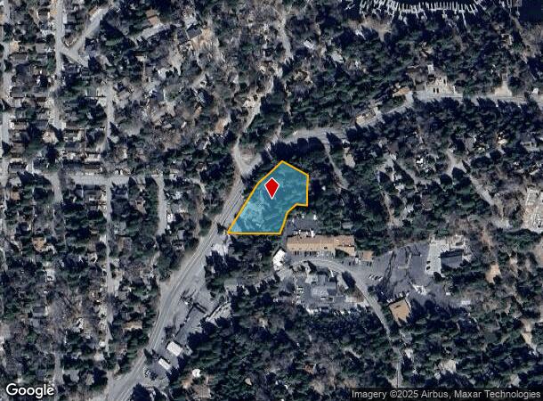
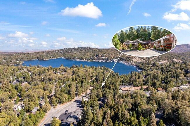
Property Record
303 S Highway 173 Hwy, Lake Arrowhead, CA 92352
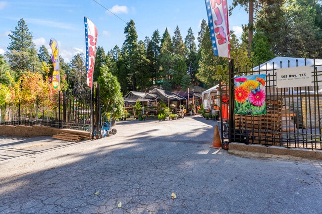
This Property Is For Sale
NEARBY LISTINGS FOR SALE OR LEASE
Property Detail
303 S Highway 173 Hwy
Riverside-San Bernardino-Ontario, CA
Arrowhead Woods
0331-037-15
TR NO 2542 ARROWHEAD WOODS TR NO 77 LOT 112 AND LOT 111 EX PTN LOT 111 COM AT SE COR SD LOT TH N 16 DEG 51 MIN W 74.18 FT TH N 55 DEG 40 MIN W 55 FT TH N 85 DEG 50 MIN W 55 FT TH S 47 DEG 30 MIN W 44 FT TH S 20 DEG 00 MIN W 79.89 FT TO PT IN S LI SD
Officebuilding
San Bernardino
D
California
06071C7243H
113
2024
1 AC
2025
San Bernardino
010906
Inland Empire (California)
184 SF
DEMOGRAPHICS near 303 S Highway 173 Hwy
1 Mile
3 Mile
5 Mile
2024 Total Population
1,272
7,794
13,863
2029 Population
1,259
7,688
13,464
Pop Growth 2024-2029
(1.02%)
(1.36%)
(2.88%)
Average Age
46
46
45
2024 Total Households
550
3,228
5,719
HH Growth 2024-2029
(1.09%)
(1.39%)
(2.92%)
Median Household Inc
$56,158
$108,116
$100,105
Avg Household Size
2.20
2.30
2.40
2024 Avg HH Vehicles
2.00
2.00
2.00
Median Home Value
$498,683
$694,905
$614,380
Median Year Built
1963
1975
1974
Nearby Places
- Restaurants
- Banks
- Shops
- Fitness
- Groceries
PUBLIC TRANSPORTATION
AIRPORT
Ontario International
DRIVE
WALK
Distance
Ontario International
64 min
44.1 mi
Freight Ports
Port of Long Beach
DRIVE
WALK
Distance
Port of Long Beach
122 min
92.1 mi
Nearby Properties
Address
Land Use
TOTAL SIZE
Lot Size
Zoning
Address
Land Use
TOTAL SIZE
Lot Size
Zoning
185,773 SF
15.42 AC
LACG
Address
Land Use
TOTAL SIZE
Lot Size
Zoning
160,928 SF
8.77 AC
LACG
Address
Land Use
TOTAL SIZE
Lot Size
Zoning
56,199 SF
540.40 AC
Address
Land Use
TOTAL SIZE
Lot Size
Zoning
32,675 SF
91.96 AC
LARC
Address
Land Use
TOTAL SIZE
Lot Size
Zoning
34,726 SF
1.02 AC
LACG
Address
Land Use
TOTAL SIZE
Lot Size
Zoning
32,648 SF
1.44 AC
LACGSCP
Address
Land Use
TOTAL SIZE
Lot Size
Zoning
Address
Land Use
TOTAL SIZE
Lot Size
Zoning
172.99 AC
Address
Land Use
TOTAL SIZE
Lot Size
Zoning
24,570 SF
2.24 AC
LACG
Address
Land Use
TOTAL SIZE
Lot Size
Zoning
11,772 SF
0.22 AC
LACG
Address
Land Use
TOTAL SIZE
Lot Size
Zoning
Address
Land Use
TOTAL SIZE
Lot Size
Zoning
143.31 AC
Address
Land Use
TOTAL SIZE
Lot Size
Zoning
22,887 SF
19.30 AC
LARS14M
Address
Land Use
TOTAL SIZE
Lot Size
Zoning
56.70 AC
LARS14M
Address
Land Use
TOTAL SIZE
Lot Size
Zoning
22,542 SF
7.03 AC
LARS14M
Address
Land Use
TOTAL SIZE
Lot Size
Zoning
20,868 SF
68.79 AC
LASDRES
Address
Land Use
TOTAL SIZE
Lot Size
Zoning
25,759 SF
0.98 AC
LACGSCP
Address
Land Use
TOTAL SIZE
Lot Size
Zoning
31,164 SF
0.82 AC
LACGSCP
Address
Land Use
TOTAL SIZE
Lot Size
Zoning
15,462 SF
0.52 AC
LACGSCP
Address
Land Use
TOTAL SIZE
Lot Size
Zoning
Address
Land Use
TOTAL SIZE
Lot Size
Zoning
20,228 SF
2.55 AC
LARS14M
Address
Land Use
TOTAL SIZE
Lot Size
Zoning
61,908 SF
0.19 AC
LACG
Address
Land Use
TOTAL SIZE
Lot Size
Zoning
2,650 SF
1.33 AC
LACG
Address
Land Use
TOTAL SIZE
Lot Size
Zoning
3.45 AC
LACGSCP
Address
Land Use
TOTAL SIZE
Lot Size
Zoning
105,000 SF
39.29 AC
LASDRES
Address
Land Use
TOTAL SIZE
Lot Size
Zoning
2,784 SF
0.70 AC
LACN
Address
Land Use
TOTAL SIZE
Lot Size
Zoning
8,501 SF
2.09 AC
LARM
Address
Land Use
TOTAL SIZE
Lot Size
Zoning
15,505 SF
5.25 AC
LARS14M
Address
Land Use
TOTAL SIZE
Lot Size
Zoning
6,022 SF
0.20 AC
LARS14M
Address
Land Use
TOTAL SIZE
Lot Size
Zoning
4,094 SF
0.18 AC
C1
The World's #1 Commercial Real Estate Marketplace
Connect with us
© 2025 CoStar Group
The information above has been obtained from sources believed reliable. While we do not doubt its accuracy we have not verified it and make no guarantee, warranty or representation about it. It is your responsibility to independently confirm its accuracy and completeness. Any projections, opinions, assumptions, or estimates used are for example only and do not represent the current or future performance of the property. The value of this transaction to you depends on tax and other factors which should be evaluated by your tax, financial, and legal advisors. You and your advisors should conduct a careful, independent investigation of the property to determine to your satisfaction the suitability of the property for your needs.