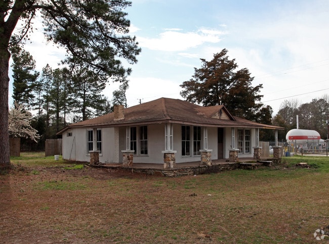
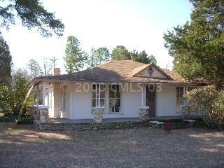
Property Record
303 Chapin Rd, Chapin, SC 29036
NEARBY LISTINGS FOR SALE OR LEASE
Property Detail
303 Chapin Rd
001100-10-033
CHAPIN PLACE PH 1A LOT 153
Commercialnec
Lexington
X
South Carolina
45063C0040J
153
2025
0.40 AC
2024
Dutch Fork/Irmo
021204
Columbia
1,891 SF
Columbia, SC
DEMOGRAPHICS near 303 Chapin Rd
1 mile
3 mile
5 mile
2024 Total Population
1,133
15,897
33,016
2029 Population
1,245
17,094
35,155
Pop Growth 2024-2029
+ 9.89%
+ 7.53%
+ 6.48%
Average Age
40
41
42
2024 Total Households
403
5,924
12,395
HH Growth 2024-2029
+ 9.93%
+ 7.65%
+ 6.67%
Median Household Inc
$84,201
$94,243
$104,367
Avg Household Size
2.70
2.60
2.60
2024 Avg HH Vehicles
2.00
2.00
2.00
Median Home Value
$257,142
$319,731
$335,219
Median Year Built
2003
2002
2002
Nearby Places
Map Layers
Map Styles
 Street
 Aerial
Transit
 Traffic
 Biking
Places
Listings with unknown addresses are not visible on the map
- Restaurants
- Banks
- Shops
- Fitness
- Groceries
PUBLIC TRANSPORTATION
AIRPORT
Columbia Metro
Drive
Walk
Distance
Columbia Metro
43 min
25.5 mi
Nearby Properties
Address
Land Use
TOTAL SIZE
Lot Size
Zoning
Address
Land Use
TOTAL SIZE
Lot Size
Zoning
31,005 SF
55.97 AC
PDD
Address
Land Use
TOTAL SIZE
Lot Size
Zoning
1,958 SF
145.19 AC
PDD
Address
Land Use
TOTAL SIZE
Lot Size
Zoning
57,020 SF
11.80 AC
PDD
Address
Land Use
TOTAL SIZE
Lot Size
Zoning
20,344 SF
13.21 AC
RU
Address
Land Use
TOTAL SIZE
Lot Size
Zoning
19,142 SF
15.08 AC
PDD
Address
Land Use
TOTAL SIZE
Lot Size
Zoning
5,050 SF
4.68 AC
RU
Address
Land Use
TOTAL SIZE
Lot Size
Zoning
7,673 SF
1.03 AC
RS-LD
Address
Land Use
TOTAL SIZE
Lot Size
Zoning
16,034 SF
4.74 AC
RU
Address
Land Use
TOTAL SIZE
Lot Size
Zoning
10,764 SF
1.84 AC
GC
Address
Land Use
TOTAL SIZE
Lot Size
Zoning
7,464 SF
1.87 AC
RS-LD
Address
Land Use
TOTAL SIZE
Lot Size
Zoning
4,263 SF
0.99 AC
RS-LD
Address
Land Use
TOTAL SIZE
Lot Size
Zoning
5,138 SF
1.47 AC
RS-LD
Address
Land Use
TOTAL SIZE
Lot Size
Zoning
15,086 SF
4.85 AC
RU
Address
Land Use
TOTAL SIZE
Lot Size
Zoning
5,668 SF
3.52 AC
RS-LD
Address
Land Use
TOTAL SIZE
Lot Size
Zoning
4,802 SF
1.11 AC
RS-LD
Address
Land Use
TOTAL SIZE
Lot Size
Zoning
3,766 SF
0.68 AC
RS-LD
Address
Land Use
TOTAL SIZE
Lot Size
Zoning
4,602 SF
2.98 AC
RS-LD
Address
Land Use
TOTAL SIZE
Lot Size
Zoning
3,897 SF
0.55 AC
RS-LD
Address
Land Use
TOTAL SIZE
Lot Size
Zoning
7,000 SF
4.74 AC
RU
Address
Land Use
TOTAL SIZE
Lot Size
Zoning
4,151 SF
1.77 AC
RS-LD
Address
Land Use
TOTAL SIZE
Lot Size
Zoning
1,949 SF
0.49 AC
RS-LD
Address
Land Use
TOTAL SIZE
Lot Size
Zoning
5,402 SF
1.77 AC
RS-LD
Address
Land Use
TOTAL SIZE
Lot Size
Zoning
9,124 SF
4.11 AC
RU
Address
Land Use
TOTAL SIZE
Lot Size
Zoning
5,771 SF
7.05 AC
RU
Address
Land Use
TOTAL SIZE
Lot Size
Zoning
5,615 SF
0.41 AC
RS-LD
Address
Land Use
TOTAL SIZE
Lot Size
Zoning
6,033 SF
0.41 AC
RS-LD
Address
Land Use
TOTAL SIZE
Lot Size
Zoning
60.57 AC
RU
Address
Land Use
TOTAL SIZE
Lot Size
Zoning
4,719 SF
1.99 AC
RS-LD
Address
Land Use
TOTAL SIZE
Lot Size
Zoning
3,578 SF
0.43 AC
RS-LD
Address
Land Use
TOTAL SIZE
Lot Size
Zoning
4,766 SF
0.48 AC
RS-LD
The World's #1 Commercial Real Estate Marketplace
Connect with us
© 2026 CoStar Group
The information above has been obtained from sources believed reliable. While we do not doubt its accuracy we have not verified it and make no guarantee, warranty or representation about it. It is your responsibility to independently confirm its accuracy and completeness. Any projections, opinions, assumptions, or estimates used are for example only and do not represent the current or future performance of the property. The value of this transaction to you depends on tax and other factors which should be evaluated by your tax, financial, and legal advisors. You and your advisors should conduct a careful, independent investigation of the property to determine to your satisfaction the suitability of the property for your needs.