Property Record
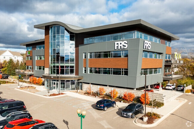
303 E 3Rd St, Rochester, MI 48307


Property Detail
303 E 3Rd St
Detroit-Warren-Dearborn, MI
T3N, R11E, SEC 14 SUPERVISOR'S PLAT NO 2, PART OF LOT 6, ALSO LOT7, ALSO OF 'EAST THIRD STREET URBAN RENEWAL PLAT' ALL OF LOT 5 ALL DESC AS BEG AT PT DIST S 87-15-57 E 328.69 FT FROM SW COR LOT 6, TH N 03-32-37 E 188.81 FT, TH N 86-26-39 W 31.38 FT,
15-14-105-014
OAKLAND
Officebuilding
Michigan
B and X Area of moderate flood hazard, usually the area between the limits of the 100-year and 500-year floods.
5-7
2024
1.66 AC
2025
Rochester
191200
Detroit
46,262 SF
NEARBY LISTINGS FOR SALE OR LEASE
DEMOGRAPHICS near 303 E 3Rd St
1 mile
3 mile
5 mile
2025 Total Population
10,277
70,694
163,044
2030 Population
10,629
72,168
166,605
Pop Growth 2025-2030
+ 3.43%
+ 2.09%
+ 2.18%
Average Age
41
42
42
2025 Total Households
4,700
28,192
64,142
HH Growth 2025-2030
+ 3.79%
+ 2.27%
+ 2.37%
Median Household Inc
$99,447
$110,864
$107,674
Avg Household Size
2.10
2.40
2.40
2025 Avg HH Vehicles
2.00
2.00
2.00
Median Home Value
$403,145
$411,651
$410,105
Median Year Built
1977
1982
1984
Nearby Places
Map Layers
Map Styles
 Street
 Aerial
Layers
 Traffic
 Biking
Places
Listings with unknown addresses are not visible on the map
- Restaurants
- Banks
- Shops
- Fitness
- Groceries
PUBLIC TRANSPORTATION
AIRPORT
Windsor International
Drive
Walk
Distance
Windsor International
60 min
35.8 mi
Detroit Metro Wayne County
Drive
Walk
Distance
Detroit Metro Wayne County
64 min
45.3 mi
SALE & LEASE HISTORY
LISTING DATE
SALE/LEASE

Oct 05, 2017
For Lease
Nearby Properties
Address
Land Use
TOTAL SIZE
Lot Size
Zoning
Address
Land Use
TOTAL SIZE
Lot Size
Zoning
444,087 SF
83.19 AC
II
Address
Land Use
TOTAL SIZE
Lot Size
Zoning
3,529 SF
29.19 AC
BI
Address
Land Use
TOTAL SIZE
Lot Size
Zoning
57.84 AC
AV
Address
Land Use
TOTAL SIZE
Lot Size
Zoning
389,465 SF
30.24 AC
II
Address
Land Use
TOTAL SIZE
Lot Size
Zoning
Address
Land Use
TOTAL SIZE
Lot Size
Zoning
195,413 SF
4.43 AC
Address
Land Use
TOTAL SIZE
Lot Size
Zoning
35.60 AC
R-12
Address
Land Use
TOTAL SIZE
Lot Size
Zoning
22.09 AC
AI
Address
Land Use
TOTAL SIZE
Lot Size
Zoning
134,904 SF
5 AC
Address
Land Use
TOTAL SIZE
Lot Size
Zoning
119.30 AC
Address
Land Use
TOTAL SIZE
Lot Size
Zoning
21.52 AC
AI
Address
Land Use
TOTAL SIZE
Lot Size
Zoning
Address
Land Use
TOTAL SIZE
Lot Size
Zoning
51.98 AC
MHP
Address
Land Use
TOTAL SIZE
Lot Size
Zoning
62,495 SF
2.49 AC
MM
Address
Land Use
TOTAL SIZE
Lot Size
Zoning
89,450 SF
0.41 AC
BI
Address
Land Use
TOTAL SIZE
Lot Size
Zoning
26.25 AC
AI
Address
Land Use
TOTAL SIZE
Lot Size
Zoning
96,460 SF
17.50 AC
Address
Land Use
TOTAL SIZE
Lot Size
Zoning
55,651 SF
23.39 AC
II
Address
Land Use
TOTAL SIZE
Lot Size
Zoning
191.40 AC
AI
Address
Land Use
TOTAL SIZE
Lot Size
Zoning
112,300 SF
25.04 AC
Address
Land Use
TOTAL SIZE
Lot Size
Zoning
139,853 SF
11.76 AC
BI
Address
Land Use
TOTAL SIZE
Lot Size
Zoning
10.88 AC
AI
Address
Land Use
TOTAL SIZE
Lot Size
Zoning
141,321 SF
9.03 AC
AI
The World's #1 Commercial Real Estate Marketplace
Connect with us
© 2026 CoStar Group
The information above has been obtained from sources believed reliable. While we do not doubt its accuracy we have not verified it and make no guarantee, warranty or representation about it. It is your responsibility to independently confirm its accuracy and completeness. Any projections, opinions, assumptions, or estimates used are for example only and do not represent the current or future performance of the property. The value of this transaction to you depends on tax and other factors which should be evaluated by your tax, financial, and legal advisors. You and your advisors should conduct a careful, independent investigation of the property to determine to your satisfaction the suitability of the property for your needs.