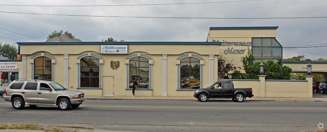
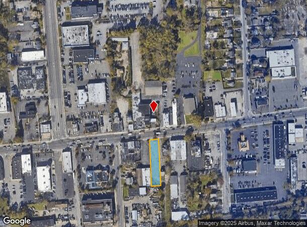
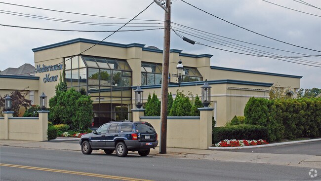
Property Record
303 E Main St, Patchogue, NY 11772
Property Detail
303 E Main St
Nassau County-Suffolk County, NY
Patchogue (A To L)
0200-977-50-03-00-009-000
N E MAIN ST S22 E KIRCHER S GIANCON
Parkinglot
Suffolk
X
New York
36103C0694H
9
2024
0.34 AC
2024
Central Suffolk
159109
Long Island (New York)
NEARBY LISTINGS FOR SALE OR LEASE
DEMOGRAPHICS near 303 E Main St
1 mile
3 mile
5 mile
2024 Total Population
12,766
66,423
148,020
2029 Population
12,517
65,683
146,594
Pop Growth 2024-2029
(1.95%)
(1.11%)
(0.96%)
Average Age
41
42
42
2024 Total Households
4,936
24,735
52,790
HH Growth 2024-2029
(2.31%)
(1.33%)
(1.18%)
Median Household Inc
$90,713
$102,882
$109,065
Avg Household Size
2.50
2.60
2.70
2024 Avg HH Vehicles
2.00
2.00
2.00
Median Home Value
$393,978
$440,279
$455,067
Median Year Built
1958
1972
1973
Nearby Places
Map Layers
Map Styles
 Street
 Aerial
Transit
 Traffic
 Biking
Places
Listings with unknown addresses are not visible on the map
- Restaurants
- Banks
- Shops
- Fitness
- Groceries
PUBLIC TRANSPORTATION
COMMUTER RAIL
Patchogue Station (Montauk Branch - Long Island Rail Road)
Drive
Walk
Distance
Patchogue Station (Montauk Branch - Long Island Rail Road)
2 min
16 min
0.8 mi
Bellport Station (Montauk Branch - Long Island Rail Road)
Drive
Walk
Distance
Bellport Station (Montauk Branch - Long Island Rail Road)
5 min
3.4 mi
AIRPORT
Long Island MacArthur
Drive
Walk
Distance
Long Island MacArthur
14 min
7.0 mi
Freight Ports
Port of New Haven
Drive
Walk
Distance
Port of New Haven
134 min
51.7 mi
Nearby Properties
Address
Land Use
TOTAL SIZE
Lot Size
Zoning
Address
Land Use
TOTAL SIZE
Lot Size
Zoning
30.25 AC
CA
Address
Land Use
TOTAL SIZE
Lot Size
Zoning
33.47 AC
AA
Address
Land Use
TOTAL SIZE
Lot Size
Zoning
3,060 SF
0.22 AC
VILLA
Address
Land Use
TOTAL SIZE
Lot Size
Zoning
7,290 SF
15.71 AC
CA
Address
Land Use
TOTAL SIZE
Lot Size
Zoning
3,034 SF
0.20 AC
VILLA
Address
Land Use
TOTAL SIZE
Lot Size
Zoning
2,196 SF
0.33 AC
VILLA
Address
Land Use
TOTAL SIZE
Lot Size
Zoning
4,220 SF
2.07 AC
R15
Address
Land Use
TOTAL SIZE
Lot Size
Zoning
3,766 SF
0.59 AC
R15
Address
Land Use
TOTAL SIZE
Lot Size
Zoning
4,446 SF
1.17 AC
CR200
Address
Land Use
TOTAL SIZE
Lot Size
Zoning
5,858 SF
1.73 AC
R40
Address
Land Use
TOTAL SIZE
Lot Size
Zoning
2,724 SF
0.32 AC
VILLA
Address
Land Use
TOTAL SIZE
Lot Size
Zoning
4,000 SF
0.30 AC
VILLA
Address
Land Use
TOTAL SIZE
Lot Size
Zoning
2,046 SF
0.21 AC
VILLA
Address
Land Use
TOTAL SIZE
Lot Size
Zoning
42.37 AC
Address
Land Use
TOTAL SIZE
Lot Size
Zoning
6,968 SF
1.15 AC
R40
Address
Land Use
TOTAL SIZE
Lot Size
Zoning
4,225 SF
1.02 AC
R40
Address
Land Use
TOTAL SIZE
Lot Size
Zoning
2,554 SF
0.50 AC
VILLA
Address
Land Use
TOTAL SIZE
Lot Size
Zoning
4,103 SF
1.16 AC
VILLA
Address
Land Use
TOTAL SIZE
Lot Size
Zoning
2,035 SF
0.15 AC
VILLA
Address
Land Use
TOTAL SIZE
Lot Size
Zoning
14.70 AC
BUS3
Address
Land Use
TOTAL SIZE
Lot Size
Zoning
3,757 SF
0.98 AC
R40
Address
Land Use
TOTAL SIZE
Lot Size
Zoning
9,148 SF
10.30 AC
CA
Address
Land Use
TOTAL SIZE
Lot Size
Zoning
2,556 SF
0.22 AC
VILLA
Address
Land Use
TOTAL SIZE
Lot Size
Zoning
1,563 SF
0.71 AC
R10
Address
Land Use
TOTAL SIZE
Lot Size
Zoning
2,123 SF
1.43 AC
R40
Address
Land Use
TOTAL SIZE
Lot Size
Zoning
3,505 SF
1.02 AC
VILLA
Address
Land Use
TOTAL SIZE
Lot Size
Zoning
4,512 SF
1.31 AC
R40
Address
Land Use
TOTAL SIZE
Lot Size
Zoning
655 SF
0.21 AC
VILLA
Address
Land Use
TOTAL SIZE
Lot Size
Zoning
3,278 SF
0.51 AC
VILLA
Address
Land Use
TOTAL SIZE
Lot Size
Zoning
3,942 SF
0.45 AC
VILLA
The World's #1 Commercial Real Estate Marketplace
Connect with us
© 2026 CoStar Group
The information above has been obtained from sources believed reliable. While we do not doubt its accuracy we have not verified it and make no guarantee, warranty or representation about it. It is your responsibility to independently confirm its accuracy and completeness. Any projections, opinions, assumptions, or estimates used are for example only and do not represent the current or future performance of the property. The value of this transaction to you depends on tax and other factors which should be evaluated by your tax, financial, and legal advisors. You and your advisors should conduct a careful, independent investigation of the property to determine to your satisfaction the suitability of the property for your needs.