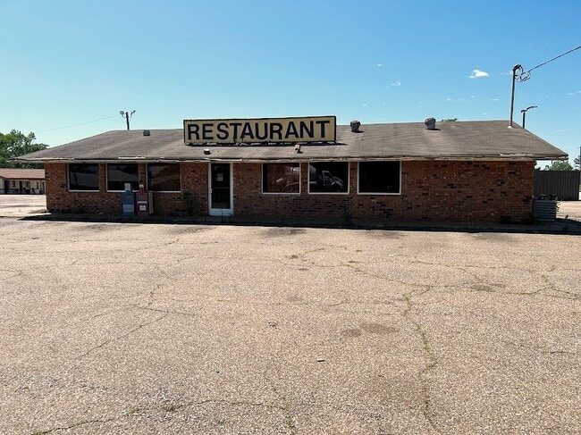
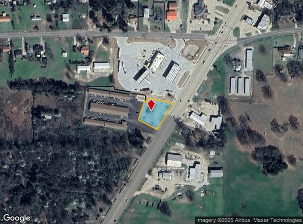
Property Record
303 Us Highway 59 S, Queen City, TX 75572
NEARBY LISTINGS FOR SALE OR LEASE
-
-
-
No Photo
-
-
-
View all Queen City listings for sale on LoopNet.com
Property Detail
303 Us Highway 59 S
44640
J RICHEY ABST 877 TR 16B .668 AC PP # 37102
Commercialnec
Cass
X
Texas
48067C0270C
16b
2025
0.67 AC
2025
Texas East Area
950101
Other Market Areas
2,640 SF
DEMOGRAPHICS near 303 Us Highway 59 S
1 Mile
3 Mile
5 Mile
2024 Total Population
1,332
7,399
9,877
2029 Population
1,349
7,512
10,001
Pop Growth 2024-2029
+ 1.28%
+ 1.53%
+ 1.26%
Average Age
40
41
42
2024 Total Households
564
2,984
4,013
HH Growth 2024-2029
+ 1.24%
+ 1.54%
+ 1.25%
Median Household Inc
$59,285
$54,301
$55,688
Avg Household Size
2.30
2.40
2.40
2024 Avg HH Vehicles
2.00
2.00
2.00
Median Home Value
$93,783
$101,997
$114,407
Median Year Built
1978
1979
1980
Nearby Places
- Restaurants
- Banks
- Shops
- Fitness
- Groceries
PUBLIC TRANSPORTATION
AIRPORT
Texarkana Regional-Webb Field
DRIVE
WALK
Distance
Texarkana Regional-Webb Field
38 min
28.9 mi
Freight Ports
Port of Shreveport
DRIVE
WALK
Distance
Port of Shreveport
104 min
81.5 mi
SALE & LEASE HISTORY
LISTING DATE
SALE/LEASE

May 04, 2023
For Sale
Nearby Properties
Address
Land Use
TOTAL SIZE
Lot Size
Zoning
Address
Land Use
TOTAL SIZE
Lot Size
Zoning
256,896 SF
127.95 AC
Address
Land Use
TOTAL SIZE
Lot Size
Zoning
122,355 SF
20.53 AC
Address
Land Use
TOTAL SIZE
Lot Size
Zoning
93,957 SF
19.71 AC
Address
Land Use
TOTAL SIZE
Lot Size
Zoning
65,178 SF
21.07 AC
Address
Land Use
TOTAL SIZE
Lot Size
Zoning
131,391 SF
50.15 AC
Address
Land Use
TOTAL SIZE
Lot Size
Zoning
65,730 SF
7.55 AC
Address
Land Use
TOTAL SIZE
Lot Size
Zoning
155,314 SF
19.11 AC
Address
Land Use
TOTAL SIZE
Lot Size
Zoning
62,914 SF
36.58 AC
Address
Land Use
TOTAL SIZE
Lot Size
Zoning
113,368 SF
0.57 AC
Address
Land Use
TOTAL SIZE
Lot Size
Zoning
36,049 SF
20.28 AC
Address
Land Use
TOTAL SIZE
Lot Size
Zoning
41,570 SF
3.76 AC
Address
Land Use
TOTAL SIZE
Lot Size
Zoning
60,210 SF
4.28 AC
Address
Land Use
TOTAL SIZE
Lot Size
Zoning
72,109 SF
6.60 AC
Address
Land Use
TOTAL SIZE
Lot Size
Zoning
88,077 SF
19.52 AC
Address
Land Use
TOTAL SIZE
Lot Size
Zoning
34,436 SF
4.71 AC
Address
Land Use
TOTAL SIZE
Lot Size
Zoning
23,737 SF
1.26 AC
Address
Land Use
TOTAL SIZE
Lot Size
Zoning
35,654 SF
1.08 AC
Address
Land Use
TOTAL SIZE
Lot Size
Zoning
28,474 SF
15.43 AC
Address
Land Use
TOTAL SIZE
Lot Size
Zoning
19,950 SF
3 AC
Address
Land Use
TOTAL SIZE
Lot Size
Zoning
18,483 SF
1.47 AC
Address
Land Use
TOTAL SIZE
Lot Size
Zoning
39,572 SF
3.53 AC
Address
Land Use
TOTAL SIZE
Lot Size
Zoning
13,706 SF
1.25 AC
Address
Land Use
TOTAL SIZE
Lot Size
Zoning
12,848 SF
3 AC
Address
Land Use
TOTAL SIZE
Lot Size
Zoning
33,471 SF
3.93 AC
Address
Land Use
TOTAL SIZE
Lot Size
Zoning
16,019 SF
1.34 AC
Address
Land Use
TOTAL SIZE
Lot Size
Zoning
16,436 SF
1.08 AC
Address
Land Use
TOTAL SIZE
Lot Size
Zoning
17,481 SF
1.41 AC
Address
Land Use
TOTAL SIZE
Lot Size
Zoning
26,432 SF
4.64 AC
Address
Land Use
TOTAL SIZE
Lot Size
Zoning
13,069 SF
1.36 AC
Address
Land Use
TOTAL SIZE
Lot Size
Zoning
24,512 SF
2.36 AC
The World's #1 Commercial Real Estate Marketplace
Connect with us
© 2025 CoStar Group
The information above has been obtained from sources believed reliable. While we do not doubt its accuracy we have not verified it and make no guarantee, warranty or representation about it. It is your responsibility to independently confirm its accuracy and completeness. Any projections, opinions, assumptions, or estimates used are for example only and do not represent the current or future performance of the property. The value of this transaction to you depends on tax and other factors which should be evaluated by your tax, financial, and legal advisors. You and your advisors should conduct a careful, independent investigation of the property to determine to your satisfaction the suitability of the property for your needs.