Property Record
303 N Main St, Platteville, CO 80651


Save to a Folder
{{folder.Name}}
{{folder.ListingIds.length}} Properties
{{folder.ListingIds.length}} Property
Create a New Folder
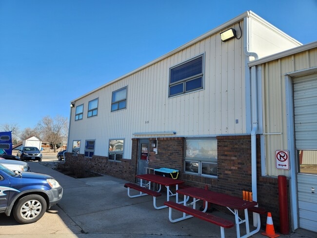
Property Detail
303 N Main St
Greeley, CO
PVI 16295-A ALL L8-9-10 & N12 L11-12 BLK11 NUCKOLLS TOG WITH N2 VAC ALLEY ADJ TO L8 ALSO ALL VAC ALLEY ADJ TO L9-10-11-12
R4869686
WELD
Warehouse
Colorado
B and X Area of moderate flood hazard, usually the area between the limits of the 100-year and 500-year floods.
8
2025
0.68 AC
2026
Weld County
001800
Denver
13,308 SF
NEARBY LISTINGS FOR SALE OR LEASE
-
-
View all Platteville listings for lease on LoopNet.com
DEMOGRAPHICS near 303 N Main St
1 mile
3 mile
5 mile
2025 Total Population
2,311
2,907
4,025
2030 Population
2,396
3,044
4,254
Pop Growth 2025-2030
+ 3.68%
+ 4.71%
+ 5.69%
Average Age
38
39
39
2025 Total Households
791
1,002
1,391
HH Growth 2025-2030
+ 4.17%
+ 5.19%
+ 6.18%
Median Household Inc
$85,474
$87,880
$89,350
Avg Household Size
2.90
2.90
2.90
2025 Avg HH Vehicles
2.00
2.00
3.00
Median Home Value
$425,138
$444,626
$452,602
Median Year Built
1989
1989
1983
Nearby Places
Map Layers
Map Styles
 Street
 Aerial
Layers
 Traffic
 Biking
Places
Listings with unknown addresses are not visible on the map
- Restaurants
- Banks
- Shops
- Fitness
- Groceries
PUBLIC TRANSPORTATION
AIRPORT
Denver International
Drive
Walk
Distance
Denver International
52 min
37.3 mi
Freight Ports
Tulsa Port Of Catoosa
Drive
Walk
Distance
Tulsa Port Of Catoosa
758 min
731.4 mi
SALE & LEASE HISTORY
LISTING DATE
SALE/LEASE

Mar 27, 2024
For Lease
Mar 27, 2024
For Sale
Nearby Properties
Address
Land Use
TOTAL SIZE
Lot Size
Zoning
Address
Land Use
TOTAL SIZE
Lot Size
Zoning
118,336 SF
14.34 AC
Address
Land Use
TOTAL SIZE
Lot Size
Zoning
34,408 SF
4.32 AC
Address
Land Use
TOTAL SIZE
Lot Size
Zoning
96,420 SF
3.50 AC
Address
Land Use
TOTAL SIZE
Lot Size
Zoning
119,770 SF
312 AC
Address
Land Use
TOTAL SIZE
Lot Size
Zoning
36,549 SF
15 AC
Address
Land Use
TOTAL SIZE
Lot Size
Zoning
41,564 SF
12.22 AC
Address
Land Use
TOTAL SIZE
Lot Size
Zoning
25,035 SF
5.95 AC
Address
Land Use
TOTAL SIZE
Lot Size
Zoning
18,375 SF
3.34 AC
Address
Land Use
TOTAL SIZE
Lot Size
Zoning
5,500 SF
1.57 AC
Address
Land Use
TOTAL SIZE
Lot Size
Zoning
18,198 SF
5.75 AC
Address
Land Use
TOTAL SIZE
Lot Size
Zoning
24,859 SF
2.78 AC
Address
Land Use
TOTAL SIZE
Lot Size
Zoning
25,125 SF
7.46 AC
Address
Land Use
TOTAL SIZE
Lot Size
Zoning
13,620 SF
5.93 AC
Address
Land Use
TOTAL SIZE
Lot Size
Zoning
17,768 SF
15.89 AC
Address
Land Use
TOTAL SIZE
Lot Size
Zoning
13,240 SF
4.25 AC
Address
Land Use
TOTAL SIZE
Lot Size
Zoning
7,083 SF
142.26 AC
Address
Land Use
TOTAL SIZE
Lot Size
Zoning
111,593 SF
312 AC
Address
Land Use
TOTAL SIZE
Lot Size
Zoning
62,570 SF
4.04 AC
Address
Land Use
TOTAL SIZE
Lot Size
Zoning
5,042 SF
1.72 AC
Address
Land Use
TOTAL SIZE
Lot Size
Zoning
11,568 SF
2.51 AC
Address
Land Use
TOTAL SIZE
Lot Size
Zoning
26,862 SF
3.34 AC
Address
Land Use
TOTAL SIZE
Lot Size
Zoning
17,870 SF
5.88 AC
Address
Land Use
TOTAL SIZE
Lot Size
Zoning
13,832 SF
3.39 AC
Address
Land Use
TOTAL SIZE
Lot Size
Zoning
14,761 SF
2.01 AC
Address
Land Use
TOTAL SIZE
Lot Size
Zoning
9,525 SF
14.25 AC
Address
Land Use
TOTAL SIZE
Lot Size
Zoning
15,685 SF
1.14 AC
Address
Land Use
TOTAL SIZE
Lot Size
Zoning
17,181 SF
4.36 AC
Address
Land Use
TOTAL SIZE
Lot Size
Zoning
13,340 SF
3.12 AC
Address
Land Use
TOTAL SIZE
Lot Size
Zoning
43,324 SF
3.21 AC
The World's #1 Commercial Real Estate Marketplace
Connect with us
© 2026 CoStar Group
The information above has been obtained from sources believed reliable. While we do not doubt its accuracy we have not verified it and make no guarantee, warranty or representation about it. It is your responsibility to independently confirm its accuracy and completeness. Any projections, opinions, assumptions, or estimates used are for example only and do not represent the current or future performance of the property. The value of this transaction to you depends on tax and other factors which should be evaluated by your tax, financial, and legal advisors. You and your advisors should conduct a careful, independent investigation of the property to determine to your satisfaction the suitability of the property for your needs.