Property Record
303 S 9Th St W, Ada, MN 56510

Save to a Folder
{{folder.Name}}
{{folder.ListingIds.length}} Properties
{{folder.ListingIds.length}} Property
Create a New Folder
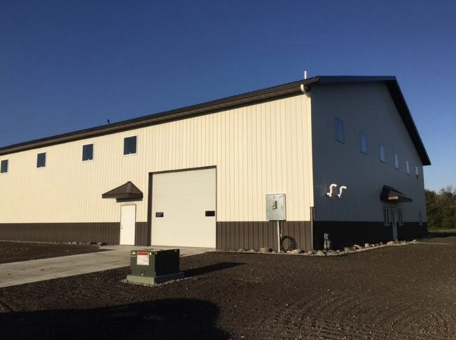
Property Detail
303 S 9Th St W
25-0980827
S 30' OF LOT 6 AND ALL OF LOT 7, BLOCK 2 ADA SOUTHWEST INDUSTRIAL PARK ADDITION
Industrialgeneral
Norman
C and X Area of minimal flood hazard, usually depicted on FIRMs as above the 500-year flood level.
Minnesota
2025
6-7
2025
0.91 AC
960300
Minnesota North Area
8,000 SF
Other Market Areas
NEARBY LISTINGS FOR SALE OR LEASE
-
-
View all Ada listings for sale on LoopNet.com
DEMOGRAPHICS near 303 S 9Th St W
1 mile
3 mile
5 mile
2025 Total Population
1,246
1,935
2,064
2030 Population
1,225
1,902
2,026
Pop Growth 2025-2030
(1.69%)
(1.71%)
(1.84%)
Average Age
42
42
42
2025 Total Households
507
808
865
HH Growth 2025-2030
(1.78%)
(1.61%)
(1.85%)
Median Household Inc
$72,403
$69,818
$69,499
Avg Household Size
2.20
2.20
2.20
2025 Avg HH Vehicles
2.00
2.00
2.00
Median Home Value
$171,138
$157,597
$156,787
Median Year Built
1965
1965
1964
Nearby Places
Map Layers
Map Styles
 Street
 Aerial
Layers
 Traffic
 Biking
Places
Listings with unknown addresses are not visible on the map
- Restaurants
- Banks
- Shops
- Fitness
- Groceries
PUBLIC TRANSPORTATION
AIRPORT
Hector International
Drive
Walk
Distance
Hector International
68 min
41.8 mi
Freight Ports
Port Milwaukee
Drive
Walk
Distance
Port Milwaukee
664 min
592.8 mi
SALE & LEASE HISTORY
LISTING DATE
SALE/LEASE

May 30, 2018
For Sale
Nearby Properties
Address
Land Use
TOTAL SIZE
Lot Size
Zoning
Address
Land Use
TOTAL SIZE
Lot Size
Zoning
53.18 AC
Address
Land Use
TOTAL SIZE
Lot Size
Zoning
15.38 AC
Address
Land Use
TOTAL SIZE
Lot Size
Zoning
1,072 SF
274 AC
Address
Land Use
TOTAL SIZE
Lot Size
Zoning
319.84 AC
Address
Land Use
TOTAL SIZE
Lot Size
Zoning
Address
Land Use
TOTAL SIZE
Lot Size
Zoning
1.93 AC
Address
Land Use
TOTAL SIZE
Lot Size
Zoning
192.17 AC
Address
Land Use
TOTAL SIZE
Lot Size
Zoning
144.98 AC
Address
Land Use
TOTAL SIZE
Lot Size
Zoning
155.78 AC
Address
Land Use
TOTAL SIZE
Lot Size
Zoning
1.72 AC
Address
Land Use
TOTAL SIZE
Lot Size
Zoning
150.54 AC
Address
Land Use
TOTAL SIZE
Lot Size
Zoning
Address
Land Use
TOTAL SIZE
Lot Size
Zoning
149.22 AC
Address
Land Use
TOTAL SIZE
Lot Size
Zoning
78.50 AC
Address
Land Use
TOTAL SIZE
Lot Size
Zoning
27.30 AC
Address
Land Use
TOTAL SIZE
Lot Size
Zoning
1.67 AC
Address
Land Use
TOTAL SIZE
Lot Size
Zoning
156.61 AC
Address
Land Use
TOTAL SIZE
Lot Size
Zoning
0.69 AC
Address
Land Use
TOTAL SIZE
Lot Size
Zoning
1.30 AC
Address
Land Use
TOTAL SIZE
Lot Size
Zoning
72.61 AC
Address
Land Use
TOTAL SIZE
Lot Size
Zoning
22,946 SF
2.35 AC
Address
Land Use
TOTAL SIZE
Lot Size
Zoning
76.98 AC
Address
Land Use
TOTAL SIZE
Lot Size
Zoning
1.46 AC
Address
Land Use
TOTAL SIZE
Lot Size
Zoning
38.85 AC
Address
Land Use
TOTAL SIZE
Lot Size
Zoning
4,800 SF
12.78 AC
Address
Land Use
TOTAL SIZE
Lot Size
Zoning
59.52 AC
Address
Land Use
TOTAL SIZE
Lot Size
Zoning
1.10 AC
Address
Land Use
TOTAL SIZE
Lot Size
Zoning
77.27 AC
Address
Land Use
TOTAL SIZE
Lot Size
Zoning
1.17 AC
The World's #1 Commercial Real Estate Marketplace
Connect with us
© 2026 CoStar Group
The information above has been obtained from sources believed reliable. While we do not doubt its accuracy we have not verified it and make no guarantee, warranty or representation about it. It is your responsibility to independently confirm its accuracy and completeness. Any projections, opinions, assumptions, or estimates used are for example only and do not represent the current or future performance of the property. The value of this transaction to you depends on tax and other factors which should be evaluated by your tax, financial, and legal advisors. You and your advisors should conduct a careful, independent investigation of the property to determine to your satisfaction the suitability of the property for your needs.