Property Record
303 S Kenmore St, South Bend, IN 46619
NEARBY LISTINGS FOR SALE OR LEASE
-
-
View all South Bend listings for sale on LoopNet.com
Property Detail
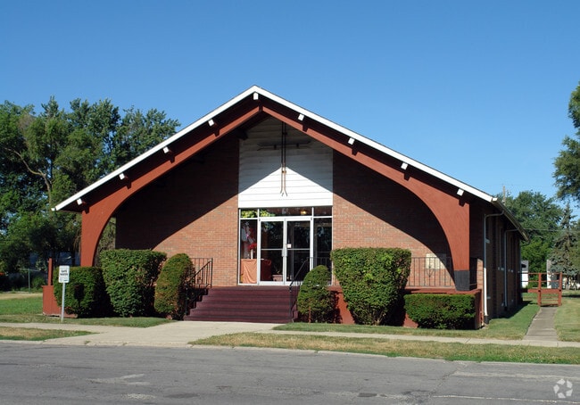
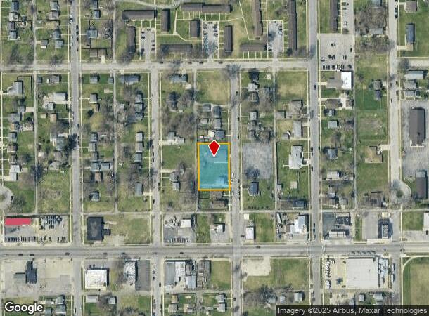
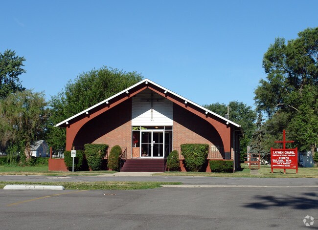
303 S Kenmore St
South Bend-Mishawaka, IN-MI
Lasalle Park
71-08-09-256-019.000-026
N 184 & S 1/2 VAC ALLEY N & ADJ LOT 1069 LASALLE PARK 07/08 CONS W/2509 & 250902 PER OWNERS REQ
Religious
St Joseph
X
Indiana
18141C0191D
1069
0
0.57 AC
2024
Greater South Bend
002300
South Bend/Mishawaka
7,810 SF
DEMOGRAPHICS near 303 S Kenmore St
1 Mile
3 Mile
5 Mile
2024 Total Population
10,828
56,591
127,271
2029 Population
10,825
57,086
127,889
Pop Growth 2024-2029
(0.03%)
+ 0.87%
+ 0.49%
Average Age
35
36
37
2024 Total Households
3,715
20,814
47,581
HH Growth 2024-2029
(0.05%)
+ 0.81%
+ 0.50%
Median Household Inc
$35,503
$40,819
$49,878
Avg Household Size
2.80
2.50
2.40
2024 Avg HH Vehicles
2.00
1.00
2.00
Median Home Value
$59,085
$81,908
$124,379
Median Year Built
1952
1952
1956
Nearby Places
Map Layers
Map Styles
 Street
 Aerial
- Restaurants
- Banks
- Shops
- Fitness
- Groceries
PUBLIC TRANSPORTATION
COMMUTER RAIL
DRIVE
WALK
Distance
5 min
1.1 mi
South Bend Airport Station (South Shore Line - Northern Indiana Commuter Transportation District (South Shore Line))
DRIVE
WALK
Distance
South Bend Airport Station (South Shore Line - Northern Indiana Commuter Transportation District (South Shore Line))
10 min
3.9 mi
AIRPORT
South Bend International
DRIVE
WALK
Distance
South Bend International
17 min
4.8 mi
Nearby Properties
Address
Land Use
TOTAL SIZE
Lot Size
Zoning
Address
Land Use
TOTAL SIZE
Lot Size
Zoning
685,709 SF
44 SF
Address
Land Use
TOTAL SIZE
Lot Size
Zoning
291,729 SF
0.79 AC
Address
Land Use
TOTAL SIZE
Lot Size
Zoning
393,123 SF
2.91 AC
Address
Land Use
TOTAL SIZE
Lot Size
Zoning
158,616 SF
0.85 AC
Address
Land Use
TOTAL SIZE
Lot Size
Zoning
194,931 SF
44 SF
Address
Land Use
TOTAL SIZE
Lot Size
Zoning
161,548 SF
44 SF
Address
Land Use
TOTAL SIZE
Lot Size
Zoning
544,872 SF
70.95 AC
Address
Land Use
TOTAL SIZE
Lot Size
Zoning
178,111 SF
44 SF
Address
Land Use
TOTAL SIZE
Lot Size
Zoning
260,370 SF
Address
Land Use
TOTAL SIZE
Lot Size
Zoning
172,368 SF
2.22 AC
Address
Land Use
TOTAL SIZE
Lot Size
Zoning
55,995 SF
0.78 AC
Address
Land Use
TOTAL SIZE
Lot Size
Zoning
633,136 SF
2.59 AC
Address
Land Use
TOTAL SIZE
Lot Size
Zoning
165,725 SF
0.01 AC
Address
Land Use
TOTAL SIZE
Lot Size
Zoning
100,368 SF
44 SF
Address
Land Use
TOTAL SIZE
Lot Size
Zoning
138,993 SF
0.38 AC
Address
Land Use
TOTAL SIZE
Lot Size
Zoning
201,264 SF
1.45 AC
Address
Land Use
TOTAL SIZE
Lot Size
Zoning
90,855 SF
3.07 AC
Address
Land Use
TOTAL SIZE
Lot Size
Zoning
284,474 SF
7.61 AC
Address
Land Use
TOTAL SIZE
Lot Size
Zoning
89,802 SF
0.68 AC
Address
Land Use
TOTAL SIZE
Lot Size
Zoning
74,976 SF
44 SF
Address
Land Use
TOTAL SIZE
Lot Size
Zoning
94,801 SF
2.70 AC
Address
Land Use
TOTAL SIZE
Lot Size
Zoning
84,105 SF
0.22 AC
Address
Land Use
TOTAL SIZE
Lot Size
Zoning
181,494 SF
1.19 AC
Address
Land Use
TOTAL SIZE
Lot Size
Zoning
85,928 SF
7.83 AC
Address
Land Use
TOTAL SIZE
Lot Size
Zoning
75,901 SF
7.68 AC
Address
Land Use
TOTAL SIZE
Lot Size
Zoning
58,135 SF
174 SF
Address
Land Use
TOTAL SIZE
Lot Size
Zoning
59,586 SF
44 SF
Address
Land Use
TOTAL SIZE
Lot Size
Zoning
78,229 SF
0.54 AC
Address
Land Use
TOTAL SIZE
Lot Size
Zoning
67,904 SF
Address
Land Use
TOTAL SIZE
Lot Size
Zoning
17,176 SF
73 AC
The World's #1 Commercial Real Estate Marketplace
Connect with us
© 2025 CoStar Group
The information above has been obtained from sources believed reliable. While we do not doubt its accuracy we have not verified it and make no guarantee, warranty or representation about it. It is your responsibility to independently confirm its accuracy and completeness. Any projections, opinions, assumptions, or estimates used are for example only and do not represent the current or future performance of the property. The value of this transaction to you depends on tax and other factors which should be evaluated by your tax, financial, and legal advisors. You and your advisors should conduct a careful, independent investigation of the property to determine to your satisfaction the suitability of the property for your needs.