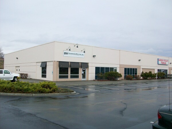
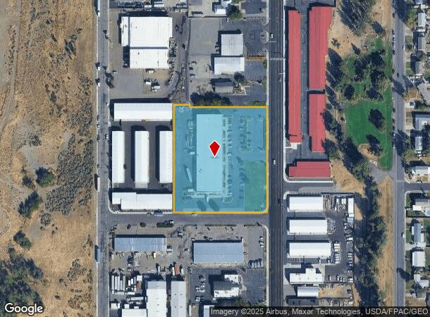
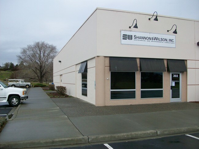
Property Record
301 Wellsian Way, Richland, WA 99352
NEARBY LISTINGS FOR SALE OR LEASE
Property Detail
301 Wellsian Way
Other Market Areas
Short Plat #3205
Kennewick-Richland, WA
SECTION 15 TOWNSHIP 9 RANGE 28 QUARTER NE; SHORT PLAT #3205, LOT 2, RECORDED 7/2/2009, UNDER AUDITORS FILE NO. 2009-019921. RECORDED IN VOLUME 1 OF SHORT PLATS, PAGE 3205, RECORDS OF BENTON COUNTY, WASHINGTON.
115981013205002
Benton
Storebuilding
Washington
2024
2
2024
3.35 AC
010600
Yakima/Kennewick
30,000 SF
DEMOGRAPHICS near 301 Wellsian Way
1 Mile
3 Mile
5 Mile
2024 Total Population
9,509
49,409
119,194
2029 Population
10,175
53,155
128,617
Pop Growth 2024-2029
+ 7.00%
+ 7.58%
+ 7.91%
Average Age
37
39
38
2024 Total Households
3,954
19,037
44,615
HH Growth 2024-2029
+ 7.11%
+ 7.57%
+ 7.84%
Median Household Inc
$70,541
$90,104
$96,502
Avg Household Size
2.30
2.60
2.60
2024 Avg HH Vehicles
2.00
2.00
2.00
Median Home Value
$266,915
$366,398
$366,629
Median Year Built
1954
1978
1997
Nearby Places
Map Layers
Map Styles
 Street
 Aerial
- Restaurants
- Banks
- Shops
- Fitness
- Groceries
PUBLIC TRANSPORTATION
AIRPORT
Tri-Cities
DRIVE
WALK
Distance
Tri-Cities
16 min
10.6 mi
Freight Ports
Port of Tacoma
DRIVE
WALK
Distance
Port of Tacoma
261 min
228.4 mi
SALE & LEASE HISTORY
LISTING DATE
SALE/LEASE

Sep 13, 2018
For Lease
Nearby Properties
Address
Land Use
TOTAL SIZE
Lot Size
Zoning
Address
Land Use
TOTAL SIZE
Lot Size
Zoning
351,518 SF
16.01 AC
Address
Land Use
TOTAL SIZE
Lot Size
Zoning
562,186 SF
7.61 AC
Address
Land Use
TOTAL SIZE
Lot Size
Zoning
277,530 SF
14.99 AC
Address
Land Use
TOTAL SIZE
Lot Size
Zoning
183,204 SF
14.94 AC
Address
Land Use
TOTAL SIZE
Lot Size
Zoning
245,782 SF
10 AC
RICHLAND -
Address
Land Use
TOTAL SIZE
Lot Size
Zoning
342,771 SF
11.59 AC
Address
Land Use
TOTAL SIZE
Lot Size
Zoning
143,592 SF
6.86 AC
RICHLAND -
Address
Land Use
TOTAL SIZE
Lot Size
Zoning
428,225 SF
12.60 AC
Address
Land Use
TOTAL SIZE
Lot Size
Zoning
351,217 SF
60.86 AC
Address
Land Use
TOTAL SIZE
Lot Size
Zoning
236,556 SF
11.34 AC
Address
Land Use
TOTAL SIZE
Lot Size
Zoning
185,302 SF
9.13 AC
Address
Land Use
TOTAL SIZE
Lot Size
Zoning
220,970 SF
1.28 AC
Address
Land Use
TOTAL SIZE
Lot Size
Zoning
216,270 SF
22.32 AC
Address
Land Use
TOTAL SIZE
Lot Size
Zoning
113,052 SF
3.32 AC
Address
Land Use
TOTAL SIZE
Lot Size
Zoning
81,497 SF
16.69 AC
Address
Land Use
TOTAL SIZE
Lot Size
Zoning
69,488 SF
1.69 AC
Address
Land Use
TOTAL SIZE
Lot Size
Zoning
170,307 SF
14.15 AC
Address
Land Use
TOTAL SIZE
Lot Size
Zoning
109,517 SF
4.67 AC
Address
Land Use
TOTAL SIZE
Lot Size
Zoning
69,697 SF
16.83 AC
Address
Land Use
TOTAL SIZE
Lot Size
Zoning
126,251 SF
7 AC
Address
Land Use
TOTAL SIZE
Lot Size
Zoning
116,318 SF
2.74 AC
Address
Land Use
TOTAL SIZE
Lot Size
Zoning
74,089 SF
12.33 AC
Address
Land Use
TOTAL SIZE
Lot Size
Zoning
76,249 SF
13 AC
Address
Land Use
TOTAL SIZE
Lot Size
Zoning
96,486 SF
13.24 AC
Address
Land Use
TOTAL SIZE
Lot Size
Zoning
208,285 SF
5.24 AC
Address
Land Use
TOTAL SIZE
Lot Size
Zoning
39,875 SF
1.80 AC
Address
Land Use
TOTAL SIZE
Lot Size
Zoning
86,104 SF
3.26 AC
Address
Land Use
TOTAL SIZE
Lot Size
Zoning
61,068 SF
0.78 AC
Address
Land Use
TOTAL SIZE
Lot Size
Zoning
160,160 SF
16.25 AC
58
Address
Land Use
TOTAL SIZE
Lot Size
Zoning
127,195 SF
9.16 AC
The World's #1 Commercial Real Estate Marketplace
Connect with us
© 2025 CoStar Group
The information above has been obtained from sources believed reliable. While we do not doubt its accuracy we have not verified it and make no guarantee, warranty or representation about it. It is your responsibility to independently confirm its accuracy and completeness. Any projections, opinions, assumptions, or estimates used are for example only and do not represent the current or future performance of the property. The value of this transaction to you depends on tax and other factors which should be evaluated by your tax, financial, and legal advisors. You and your advisors should conduct a careful, independent investigation of the property to determine to your satisfaction the suitability of the property for your needs.