Property Record
3030 W 81St Ave, Westminster, CO 80031
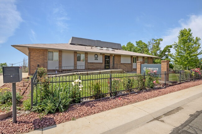
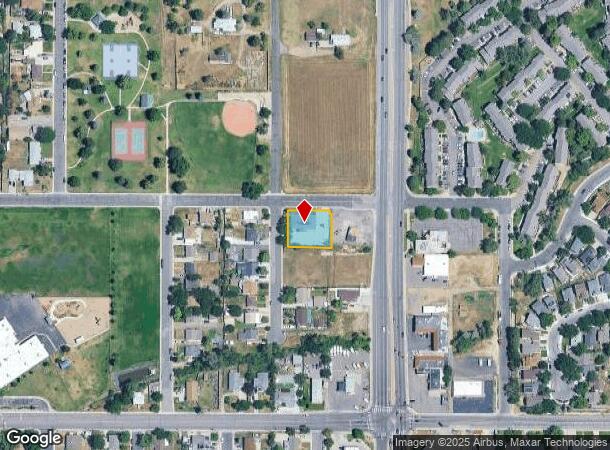


Property Detail
3030 W 81St Ave
Denver-Aurora-Centennial, CO
Westminster
1719-29-3-22-001
SUB:WESTMINSTER BLK:120 DESC: LOTS 1 TO 4 INC TOG WITH VAC S 10 FT OF W 81ST AVE ADJ LOT 1 ON N
Officebuilding
Adams
ARE
Colorado
08059C0209F
1-4,1
2024
0.29 AC
2025
Northwest Denver
009401
Denver
4,640 SF
NEARBY LISTINGS FOR SALE OR LEASE
DEMOGRAPHICS near 3030 W 81St Ave
1 mile
3 mile
5 mile
2024 Total Population
17,349
153,938
332,045
2029 Population
17,937
158,347
338,646
Pop Growth 2024-2029
+ 3.39%
+ 2.86%
+ 1.99%
Average Age
38
37
38
2024 Total Households
6,451
56,305
126,449
HH Growth 2024-2029
+ 3.64%
+ 2.90%
+ 1.89%
Median Household Inc
$61,652
$66,899
$77,166
Avg Household Size
2.60
2.60
2.50
2024 Avg HH Vehicles
2.00
2.00
2.00
Median Home Value
$359,787
$383,157
$427,753
Median Year Built
1966
1976
1977
Nearby Places
Map Layers
Map Styles
 Street
 Aerial
Transit
 Traffic
 Biking
Places
Listings with unknown addresses are not visible on the map
- Restaurants
- Banks
- Shops
- Fitness
- Groceries
PUBLIC TRANSPORTATION
COMMUTER RAIL
Westminster Station S-Bound (Union Station to Westminster Station - Regional Transportation District)
Drive
Walk
Distance
Westminster Station S-Bound (Union Station to Westminster Station - Regional Transportation District)
4 min
1.7 mi
Westminster Station N-Bound (Union Station to Westminster Station - Regional Transportation District)
Drive
Walk
Distance
Westminster Station N-Bound (Union Station to Westminster Station - Regional Transportation District)
5 min
2.1 mi
AIRPORT
Denver International
Drive
Walk
Distance
Denver International
34 min
26.3 mi
Freight Ports
Tulsa Port Of Catoosa
Drive
Walk
Distance
Tulsa Port Of Catoosa
731 min
711.8 mi
SALE & LEASE HISTORY
LISTING DATE
SALE/LEASE

Jul 17, 2023
For Sale
Nearby Properties
Address
Land Use
TOTAL SIZE
Lot Size
Zoning
Address
Land Use
TOTAL SIZE
Lot Size
Zoning
21,306 SF
2.43 AC
Address
Land Use
TOTAL SIZE
Lot Size
Zoning
271,631 SF
12.84 AC
Address
Land Use
TOTAL SIZE
Lot Size
Zoning
216,285 SF
6 AC
Address
Land Use
TOTAL SIZE
Lot Size
Zoning
208,500 SF
8.42 AC
Address
Land Use
TOTAL SIZE
Lot Size
Zoning
138,770 SF
4.64 AC
Address
Land Use
TOTAL SIZE
Lot Size
Zoning
140,430 SF
8.39 AC
Address
Land Use
TOTAL SIZE
Lot Size
Zoning
138,912 SF
8.71 AC
Address
Land Use
TOTAL SIZE
Lot Size
Zoning
261,540 SF
19.23 AC
Address
Land Use
TOTAL SIZE
Lot Size
Zoning
170,210 SF
9 AC
Address
Land Use
TOTAL SIZE
Lot Size
Zoning
113,385 SF
6.77 AC
Address
Land Use
TOTAL SIZE
Lot Size
Zoning
398,180 SF
33.31 AC
R1C
Address
Land Use
TOTAL SIZE
Lot Size
Zoning
58,750 SF
1.52 AC
Address
Land Use
TOTAL SIZE
Lot Size
Zoning
86,816 SF
4.95 AC
Address
Land Use
TOTAL SIZE
Lot Size
Zoning
79,636 SF
4.91 AC
Address
Land Use
TOTAL SIZE
Lot Size
Zoning
305,110 SF
16.87 AC
Address
Land Use
TOTAL SIZE
Lot Size
Zoning
110,878 SF
4.65 AC
Address
Land Use
TOTAL SIZE
Lot Size
Zoning
105,600 SF
1.31 AC
Address
Land Use
TOTAL SIZE
Lot Size
Zoning
65,336 SF
2.86 AC
Address
Land Use
TOTAL SIZE
Lot Size
Zoning
64,106 SF
4.10 AC
Address
Land Use
TOTAL SIZE
Lot Size
Zoning
74,432 SF
4.47 AC
Address
Land Use
TOTAL SIZE
Lot Size
Zoning
309,126 SF
5.75 AC
Address
Land Use
TOTAL SIZE
Lot Size
Zoning
147,009 SF
36.94 AC
I3
Address
Land Use
TOTAL SIZE
Lot Size
Zoning
69,537 SF
4.49 AC
Address
Land Use
TOTAL SIZE
Lot Size
Zoning
6,731 SF
80.77 AC
Address
Land Use
TOTAL SIZE
Lot Size
Zoning
51,312 SF
2.17 AC
PUD
Address
Land Use
TOTAL SIZE
Lot Size
Zoning
53,602 SF
2.37 AC
Address
Land Use
TOTAL SIZE
Lot Size
Zoning
674,481 SF
21.06 AC
Address
Land Use
TOTAL SIZE
Lot Size
Zoning
62,025 SF
2.49 AC
R4
Address
Land Use
TOTAL SIZE
Lot Size
Zoning
516,425 SF
24.42 AC
Address
Land Use
TOTAL SIZE
Lot Size
Zoning
157,724 SF
10.07 AC
The World's #1 Commercial Real Estate Marketplace
Connect with us
© 2026 CoStar Group
The information above has been obtained from sources believed reliable. While we do not doubt its accuracy we have not verified it and make no guarantee, warranty or representation about it. It is your responsibility to independently confirm its accuracy and completeness. Any projections, opinions, assumptions, or estimates used are for example only and do not represent the current or future performance of the property. The value of this transaction to you depends on tax and other factors which should be evaluated by your tax, financial, and legal advisors. You and your advisors should conduct a careful, independent investigation of the property to determine to your satisfaction the suitability of the property for your needs.