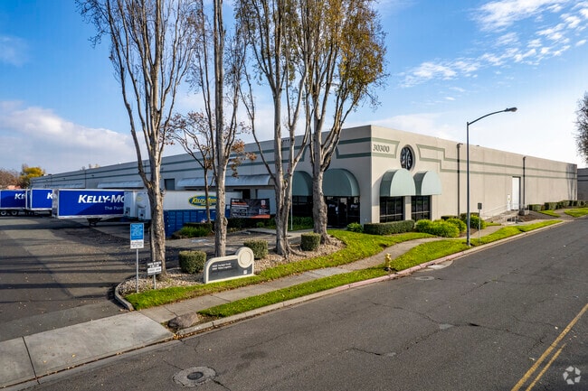
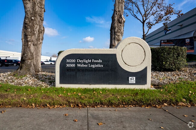
Property Record
30300 Whipple Rd, Union City, CA 94587


Current Lease Availabilities
NEARBY LISTINGS FOR SALE OR LEASE
Property Detail
30300 Whipple Rd
482-0096-005-00
LOT: 00003 BLK: TR: 5514 ;LOT: 00004 BLK: TR: 5514 ;LOT: 00005 BLK: TR: 5514
Warehouse
Alameda
AE
California
06001C0427G
3
2024
5.41 AC
2025
Union City
440331
East Bay/Oakland
126,180 SF
Oakland-Hayward-Berkeley, CA
DEMOGRAPHICS near 30300 Whipple Rd
1 Mile
3 Mile
5 Mile
2024 Total Population
12,013
122,684
282,569
2029 Population
11,521
118,606
273,120
Pop Growth 2024-2029
(4.10%)
(3.32%)
(3.34%)
Average Age
41
41
40
2024 Total Households
3,359
35,830
86,109
HH Growth 2024-2029
(4.32%)
(3.53%)
(3.55%)
Median Household Inc
$138,860
$115,500
$120,393
Avg Household Size
3.50
3.30
3.20
2024 Avg HH Vehicles
3.00
2.00
2.00
Median Home Value
$1,039,093
$841,201
$867,236
Median Year Built
1988
1976
1975
Nearby Places
Map Layers
Map Styles
 Street
 Aerial
- Restaurants
- Banks
- Shops
- Fitness
- Groceries
PUBLIC TRANSPORTATION
COMMUTER RAIL
DRIVE
WALK
Distance
13 min
5.8 mi
Fremont-Centerville (Altamont Corridor Express - Altamont Commuter Express (ACE))
DRIVE
WALK
Distance
Fremont-Centerville (Altamont Corridor Express - Altamont Commuter Express (ACE))
14 min
6.0 mi
AIRPORT
Metro Oakland International
DRIVE
WALK
Distance
Metro Oakland International
24 min
14.8 mi
San Francisco International
DRIVE
WALK
Distance
San Francisco International
34 min
23.4 mi
Norman Y Mineta San Jose International
DRIVE
WALK
Distance
Norman Y Mineta San Jose International
33 min
23.6 mi
Nearby Properties
Address
Land Use
TOTAL SIZE
Lot Size
Zoning
Address
Land Use
TOTAL SIZE
Lot Size
Zoning
367,398 SF
21.94 AC
Address
Land Use
TOTAL SIZE
Lot Size
Zoning
6.57 AC
Address
Land Use
TOTAL SIZE
Lot Size
Zoning
240,556 SF
11.63 AC
Address
Land Use
TOTAL SIZE
Lot Size
Zoning
312,244 SF
31.84 AC
Address
Land Use
TOTAL SIZE
Lot Size
Zoning
52,720 SF
4.21 AC
Address
Land Use
TOTAL SIZE
Lot Size
Zoning
200,451 SF
11.22 AC
Address
Land Use
TOTAL SIZE
Lot Size
Zoning
236,976 SF
18.36 AC
Address
Land Use
TOTAL SIZE
Lot Size
Zoning
173,948 SF
6.10 AC
Address
Land Use
TOTAL SIZE
Lot Size
Zoning
10.64 AC
Address
Land Use
TOTAL SIZE
Lot Size
Zoning
333,302 SF
13.20 AC
Address
Land Use
TOTAL SIZE
Lot Size
Zoning
175,325 SF
2.91 AC
Address
Land Use
TOTAL SIZE
Lot Size
Zoning
258,470 SF
11.64 AC
Address
Land Use
TOTAL SIZE
Lot Size
Zoning
Address
Land Use
TOTAL SIZE
Lot Size
Zoning
58,991 SF
9.56 AC
Address
Land Use
TOTAL SIZE
Lot Size
Zoning
300,507 SF
15.52 AC
Address
Land Use
TOTAL SIZE
Lot Size
Zoning
234,858 SF
8.72 AC
I
Address
Land Use
TOTAL SIZE
Lot Size
Zoning
89,145 SF
5.12 AC
Address
Land Use
TOTAL SIZE
Lot Size
Zoning
242,861 SF
17.57 AC
Address
Land Use
TOTAL SIZE
Lot Size
Zoning
154,113 SF
14.10 AC
Address
Land Use
TOTAL SIZE
Lot Size
Zoning
124,292 SF
9.69 AC
Address
Land Use
TOTAL SIZE
Lot Size
Zoning
89,344 SF
4.36 AC
Address
Land Use
TOTAL SIZE
Lot Size
Zoning
214,200 SF
9.04 AC
Address
Land Use
TOTAL SIZE
Lot Size
Zoning
200,384 SF
10.26 AC
Address
Land Use
TOTAL SIZE
Lot Size
Zoning
146,944 SF
4.21 AC
Address
Land Use
TOTAL SIZE
Lot Size
Zoning
266,149 SF
13.45 AC
I
Address
Land Use
TOTAL SIZE
Lot Size
Zoning
92,922 SF
5 AC
Address
Land Use
TOTAL SIZE
Lot Size
Zoning
168,372 SF
10.90 AC
Address
Land Use
TOTAL SIZE
Lot Size
Zoning
100,128 SF
0.98 AC
Address
Land Use
TOTAL SIZE
Lot Size
Zoning
59,012 SF
5.51 AC
Address
Land Use
TOTAL SIZE
Lot Size
Zoning
79,075 SF
4.32 AC
The World's #1 Commercial Real Estate Marketplace
Connect with us
© 2026 CoStar Group
The information above has been obtained from sources believed reliable. While we do not doubt its accuracy we have not verified it and make no guarantee, warranty or representation about it. It is your responsibility to independently confirm its accuracy and completeness. Any projections, opinions, assumptions, or estimates used are for example only and do not represent the current or future performance of the property. The value of this transaction to you depends on tax and other factors which should be evaluated by your tax, financial, and legal advisors. You and your advisors should conduct a careful, independent investigation of the property to determine to your satisfaction the suitability of the property for your needs.