Property Record
3031 E 42Nd St, Yuma, AZ 85365
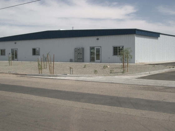

Property Detail
3031 E 42Nd St
723-13-001
SECTION: 13 TOWNSHIP: 09S RANGE: 23W NW4 NW4 SW4 NW4 EXC S 8 FT OF N 38 FT PER 9720545, 29705 & EXC W 50 R/W PER 2044/614 & 2001009320 & 2008-08848
Warehouse
Yuma
LI
Arizona
C and X Area of minimal flood hazard, usually depicted on FIRMs as above the 500-year flood level.
1.91 AC
2025
Yuma & El Centro
2026
Other Market Areas
011107
Yuma, AZ
12,500 SF
NEARBY LISTINGS FOR SALE OR LEASE
-
-
View all Yuma listings for sale on LoopNet.com
DEMOGRAPHICS near 3031 E 42Nd St
1 mile
3 mile
5 mile
2025 Total Population
2,944
23,346
70,391
2030 Population
3,206
25,484
76,614
Pop Growth 2025-2030
+ 8.90%
+ 9.16%
+ 8.84%
Average Age
24
41
38
2025 Total Households
661
8,828
25,384
HH Growth 2025-2030
+ 10.59%
+ 10.39%
+ 9.97%
Median Household Inc
$56,126
$64,611
$63,408
Avg Household Size
3.10
2.50
2.60
2025 Avg HH Vehicles
2.00
2.00
2.00
Median Home Value
$415,384
$215,512
$235,504
Median Year Built
1995
1991
1989
Nearby Places
Map Layers
Map Styles
 Street
 Aerial
Transit
 Traffic
 Biking
Places
Listings with unknown addresses are not visible on the map
- Restaurants
- Banks
- Shops
- Fitness
- Groceries
PUBLIC TRANSPORTATION
COMMUTER RAIL
Drive
Walk
Distance
11 min
6.5 mi
AIRPORT
Yuma International
Drive
Walk
Distance
Yuma International
10 min
4.4 mi
Nearby Properties
Address
Land Use
TOTAL SIZE
Lot Size
Zoning
Address
Land Use
TOTAL SIZE
Lot Size
Zoning
383,461 SF
93.30 AC
LI
Address
Land Use
TOTAL SIZE
Lot Size
Zoning
300,746 SF
17.42 AC
LI
Address
Land Use
TOTAL SIZE
Lot Size
Zoning
115,155 SF
17.69 AC
LI
Address
Land Use
TOTAL SIZE
Lot Size
Zoning
15,815 SF
4.40 AC
LI
Address
Land Use
TOTAL SIZE
Lot Size
Zoning
407,940 SF
24.04 AC
HI
Address
Land Use
TOTAL SIZE
Lot Size
Zoning
51,586 SF
6.71 AC
B-2
Address
Land Use
TOTAL SIZE
Lot Size
Zoning
119,714 SF
6.75 AC
C-2
Address
Land Use
TOTAL SIZE
Lot Size
Zoning
264,412 SF
28.05 AC
LI
Address
Land Use
TOTAL SIZE
Lot Size
Zoning
114,420 SF
6.13 AC
B-2
Address
Land Use
TOTAL SIZE
Lot Size
Zoning
132,480 SF
23.73 AC
LI
Address
Land Use
TOTAL SIZE
Lot Size
Zoning
103,803 SF
22.50 AC
LI
Address
Land Use
TOTAL SIZE
Lot Size
Zoning
97,660 SF
8.81 AC
B-2
Address
Land Use
TOTAL SIZE
Lot Size
Zoning
91,382 SF
52.31 AC
HI
Address
Land Use
TOTAL SIZE
Lot Size
Zoning
96,278 SF
9.71 AC
B-1
Address
Land Use
TOTAL SIZE
Lot Size
Zoning
69,315 SF
22.47 AC
LI
Address
Land Use
TOTAL SIZE
Lot Size
Zoning
67,495 SF
5.21 AC
B-2
Address
Land Use
TOTAL SIZE
Lot Size
Zoning
103,442 SF
9.21 AC
LI
Address
Land Use
TOTAL SIZE
Lot Size
Zoning
40,015 SF
75 AC
HI
Address
Land Use
TOTAL SIZE
Lot Size
Zoning
48,161 SF
4.98 AC
B-2
Address
Land Use
TOTAL SIZE
Lot Size
Zoning
72,900 SF
17.82 AC
LI
Address
Land Use
TOTAL SIZE
Lot Size
Zoning
86,441 SF
8.90 AC
LI
Address
Land Use
TOTAL SIZE
Lot Size
Zoning
43,543 SF
4.55 AC
B-2
Address
Land Use
TOTAL SIZE
Lot Size
Zoning
56,517 SF
12.53 AC
HI
Address
Land Use
TOTAL SIZE
Lot Size
Zoning
34,576 SF
4.28 AC
B-2
Address
Land Use
TOTAL SIZE
Lot Size
Zoning
75,968 SF
4.61 AC
R-3
Address
Land Use
TOTAL SIZE
Lot Size
Zoning
79,996 SF
9.39 AC
LI
Address
Land Use
TOTAL SIZE
Lot Size
Zoning
67,774 SF
5.67 AC
B-2
Address
Land Use
TOTAL SIZE
Lot Size
Zoning
74,884 SF
6.82 AC
B-2
Address
Land Use
TOTAL SIZE
Lot Size
Zoning
59,852 SF
17.79 AC
LI
Address
Land Use
TOTAL SIZE
Lot Size
Zoning
72,976 SF
7.69 AC
LI
The World's #1 Commercial Real Estate Marketplace
Connect with us
© 2026 CoStar Group
The information above has been obtained from sources believed reliable. While we do not doubt its accuracy we have not verified it and make no guarantee, warranty or representation about it. It is your responsibility to independently confirm its accuracy and completeness. Any projections, opinions, assumptions, or estimates used are for example only and do not represent the current or future performance of the property. The value of this transaction to you depends on tax and other factors which should be evaluated by your tax, financial, and legal advisors. You and your advisors should conduct a careful, independent investigation of the property to determine to your satisfaction the suitability of the property for your needs.