Property Record
3031 E County Road O, Janesville, WI 53546


NEARBY LISTINGS FOR SALE OR LEASE
-
-
View all Janesville listings for sale on LoopNet.com
Property Detail
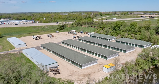
3031 E County Road O
610-30
PT S1/2 NE1/4 COM NW COR E 900', S 500', SW TO N LN HWY, W TO W LN, N TO POB (EXC I-90) (EXC COM 826.55'N & 1735.58' W OF E1/
Marshland
Rock
X
Wisconsin
55105C0211E
9.44 AC
0
Rock County
2025
Milwaukee/Madison
001400
Janesville-Beloit, WI
DEMOGRAPHICS near 3031 E County Road O
1 Mile
3 Mile
5 Mile
2024 Total Population
1,330
36,890
64,298
2029 Population
1,337
37,087
64,778
Pop Growth 2024-2029
+ 0.53%
+ 0.53%
+ 0.75%
Average Age
42
41
41
2024 Total Households
616
15,854
26,866
HH Growth 2024-2029
+ 0.49%
+ 0.59%
+ 0.76%
Median Household Inc
$84,019
$59,507
$64,918
Avg Household Size
2.10
2.30
2.30
2024 Avg HH Vehicles
2.00
2.00
2.00
Median Home Value
$194,940
$171,034
$181,399
Median Year Built
1973
1967
1971
Nearby Places
Map Layers
Map Styles
 Street
 Aerial
- Restaurants
- Banks
- Shops
- Fitness
- Groceries
SALE & LEASE HISTORY
LISTING DATE
SALE/LEASE

Jun 19, 2024
For Sale
Nearby Properties
Address
Land Use
TOTAL SIZE
Lot Size
Zoning
Address
Land Use
TOTAL SIZE
Lot Size
Zoning
56.41 AC
M2
Address
Land Use
TOTAL SIZE
Lot Size
Zoning
700,000 SF
50.74 AC
M1
Address
Land Use
TOTAL SIZE
Lot Size
Zoning
32,518 SF
26.74 AC
B4
Address
Land Use
TOTAL SIZE
Lot Size
Zoning
31,064 SF
11.57 AC
R3
Address
Land Use
TOTAL SIZE
Lot Size
Zoning
12,620 SF
8.05 AC
R3
Address
Land Use
TOTAL SIZE
Lot Size
Zoning
48,110 SF
13.04 AC
R3
Address
Land Use
TOTAL SIZE
Lot Size
Zoning
16,959 SF
47.11 AC
M1
Address
Land Use
TOTAL SIZE
Lot Size
Zoning
70,000 SF
63.05 AC
M1
Address
Land Use
TOTAL SIZE
Lot Size
Zoning
24.75 AC
Address
Land Use
TOTAL SIZE
Lot Size
Zoning
250,000 SF
22.56 AC
M1
Address
Land Use
TOTAL SIZE
Lot Size
Zoning
7.52 AC
R3
Address
Land Use
TOTAL SIZE
Lot Size
Zoning
149,400 SF
13.04 AC
M1
Address
Land Use
TOTAL SIZE
Lot Size
Zoning
161,629 SF
16.91 AC
M1
Address
Land Use
TOTAL SIZE
Lot Size
Zoning
17,183 SF
6.65 AC
B3
Address
Land Use
TOTAL SIZE
Lot Size
Zoning
178,710 SF
9.92 AC
M1
Address
Land Use
TOTAL SIZE
Lot Size
Zoning
178,710 SF
14.73 AC
M1
Address
Land Use
TOTAL SIZE
Lot Size
Zoning
12.42 AC
M1
Address
Land Use
TOTAL SIZE
Lot Size
Zoning
200,500 SF
22.73 AC
M1
Address
Land Use
TOTAL SIZE
Lot Size
Zoning
49,053 SF
9.59 AC
M1
Address
Land Use
TOTAL SIZE
Lot Size
Zoning
110,000 SF
14.14 AC
M1
Address
Land Use
TOTAL SIZE
Lot Size
Zoning
101,195 SF
1.40 AC
B6
Address
Land Use
TOTAL SIZE
Lot Size
Zoning
2,480 SF
16.27 AC
M2
Address
Land Use
TOTAL SIZE
Lot Size
Zoning
49,524 SF
1.57 AC
B6
Address
Land Use
TOTAL SIZE
Lot Size
Zoning
110,100 SF
15.75 AC
M1
Address
Land Use
TOTAL SIZE
Lot Size
Zoning
9,246 SF
0.59 AC
B5
Address
Land Use
TOTAL SIZE
Lot Size
Zoning
16,240 SF
10.64 AC
B3
Address
Land Use
TOTAL SIZE
Lot Size
Zoning
7.25 AC
M1
Address
Land Use
TOTAL SIZE
Lot Size
Zoning
4.31 AC
Address
Land Use
TOTAL SIZE
Lot Size
Zoning
24,944 SF
5.08 AC
R3
Address
Land Use
TOTAL SIZE
Lot Size
Zoning
12.44 AC
M1
The World's #1 Commercial Real Estate Marketplace
Connect with us
© 2026 CoStar Group
The information above has been obtained from sources believed reliable. While we do not doubt its accuracy we have not verified it and make no guarantee, warranty or representation about it. It is your responsibility to independently confirm its accuracy and completeness. Any projections, opinions, assumptions, or estimates used are for example only and do not represent the current or future performance of the property. The value of this transaction to you depends on tax and other factors which should be evaluated by your tax, financial, and legal advisors. You and your advisors should conduct a careful, independent investigation of the property to determine to your satisfaction the suitability of the property for your needs.