Property Record
3031 Eldamain Rd, Plano, IL 60545
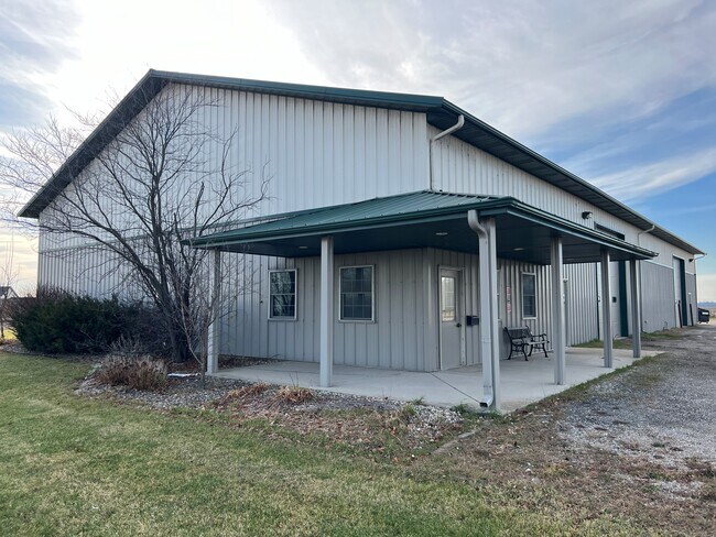

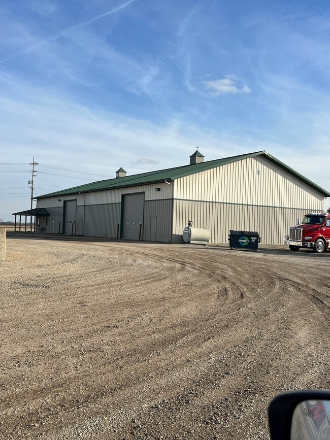
Property Detail
3031 Eldamain Rd
Chicago-Naperville-Elgin, IL-IN
LOT 1 MCKIRGANS SECOND SUB CITY OF PLANO
01-24-200-018
Kendall
Commercialnec
Illinois
B and X Area of moderate flood hazard, usually the area between the limits of the 100-year and 500-year floods.
1
2024
2 AC
2024
I-88 West
890501
Chicago
NEARBY LISTINGS FOR SALE OR LEASE
-
-
View all Plano listings for lease on LoopNet.com
DEMOGRAPHICS near 3031 Eldamain Rd
1 mile
3 mile
5 mile
2025 Total Population
2,098
21,178
45,807
2030 Population
2,225
22,667
49,296
Pop Growth 2025-2030
+ 6.05%
+ 7.03%
+ 7.62%
Average Age
34
37
38
2025 Total Households
660
7,190
15,571
HH Growth 2025-2030
+ 6.06%
+ 6.91%
+ 7.49%
Median Household Inc
$91,935
$96,104
$103,764
Avg Household Size
3.10
2.90
2.90
2025 Avg HH Vehicles
2.00
2.00
2.00
Median Home Value
$232,189
$256,803
$295,269
Median Year Built
2004
2000
2001
Nearby Places
Map Layers
Map Styles
 Street
 Aerial
Transit
 Traffic
 Biking
Places
Listings with unknown addresses are not visible on the map
- Restaurants
- Banks
- Shops
- Fitness
- Groceries
PUBLIC TRANSPORTATION
COMMUTER RAIL
Drive
Walk
Distance
7 min
3.5 mi
SALE & LEASE HISTORY
LISTING DATE
SALE/LEASE

Dec 12, 2023
For Lease
Dec 12, 2023
For Sale
Nearby Properties
Address
Land Use
TOTAL SIZE
Lot Size
Zoning
Address
Land Use
TOTAL SIZE
Lot Size
Zoning
1,703,170 SF
266.50 AC
Address
Land Use
TOTAL SIZE
Lot Size
Zoning
156,075 SF
16.27 AC
Address
Land Use
TOTAL SIZE
Lot Size
Zoning
64,667 SF
6.15 AC
Address
Land Use
TOTAL SIZE
Lot Size
Zoning
34,047 SF
7.36 AC
Address
Land Use
TOTAL SIZE
Lot Size
Zoning
184,454 SF
8.05 AC
Address
Land Use
TOTAL SIZE
Lot Size
Zoning
211,068 SF
13.09 AC
Address
Land Use
TOTAL SIZE
Lot Size
Zoning
120.35 AC
Address
Land Use
TOTAL SIZE
Lot Size
Zoning
177,481 SF
14.11 AC
Address
Land Use
TOTAL SIZE
Lot Size
Zoning
64,781 SF
1.62 AC
Address
Land Use
TOTAL SIZE
Lot Size
Zoning
15,913 SF
31.25 AC
Address
Land Use
TOTAL SIZE
Lot Size
Zoning
108,848 SF
5.79 AC
Address
Land Use
TOTAL SIZE
Lot Size
Zoning
102,020 SF
6 AC
Address
Land Use
TOTAL SIZE
Lot Size
Zoning
107,162 SF
10.49 AC
Address
Land Use
TOTAL SIZE
Lot Size
Zoning
16,100 SF
5.14 AC
Address
Land Use
TOTAL SIZE
Lot Size
Zoning
21,800 SF
2.79 AC
Address
Land Use
TOTAL SIZE
Lot Size
Zoning
58,960 SF
1.27 AC
Address
Land Use
TOTAL SIZE
Lot Size
Zoning
38,500 SF
7.06 AC
Address
Land Use
TOTAL SIZE
Lot Size
Zoning
62,648 SF
3.06 AC
Address
Land Use
TOTAL SIZE
Lot Size
Zoning
19,012 SF
3.02 AC
Address
Land Use
TOTAL SIZE
Lot Size
Zoning
60,078 SF
3.18 AC
Address
Land Use
TOTAL SIZE
Lot Size
Zoning
90,533 SF
7.18 AC
Address
Land Use
TOTAL SIZE
Lot Size
Zoning
20,850 SF
1.06 AC
Address
Land Use
TOTAL SIZE
Lot Size
Zoning
121,275 SF
15.67 AC
Address
Land Use
TOTAL SIZE
Lot Size
Zoning
20,654 SF
2.38 AC
Address
Land Use
TOTAL SIZE
Lot Size
Zoning
15,632 SF
2.83 AC
Address
Land Use
TOTAL SIZE
Lot Size
Zoning
21,620 SF
1.45 AC
Address
Land Use
TOTAL SIZE
Lot Size
Zoning
39,784 SF
3.79 AC
Address
Land Use
TOTAL SIZE
Lot Size
Zoning
18,066 SF
1.68 AC
Address
Land Use
TOTAL SIZE
Lot Size
Zoning
43,276 SF
3.60 AC
Address
Land Use
TOTAL SIZE
Lot Size
Zoning
3,772 SF
1.51 AC
The World's #1 Commercial Real Estate Marketplace
Connect with us
© 2026 CoStar Group
The information above has been obtained from sources believed reliable. While we do not doubt its accuracy we have not verified it and make no guarantee, warranty or representation about it. It is your responsibility to independently confirm its accuracy and completeness. Any projections, opinions, assumptions, or estimates used are for example only and do not represent the current or future performance of the property. The value of this transaction to you depends on tax and other factors which should be evaluated by your tax, financial, and legal advisors. You and your advisors should conduct a careful, independent investigation of the property to determine to your satisfaction the suitability of the property for your needs.