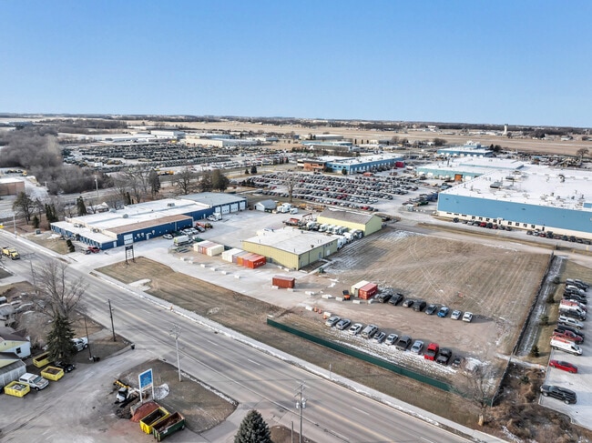
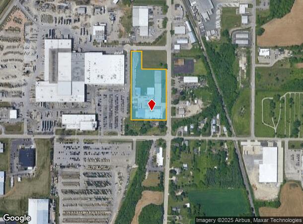
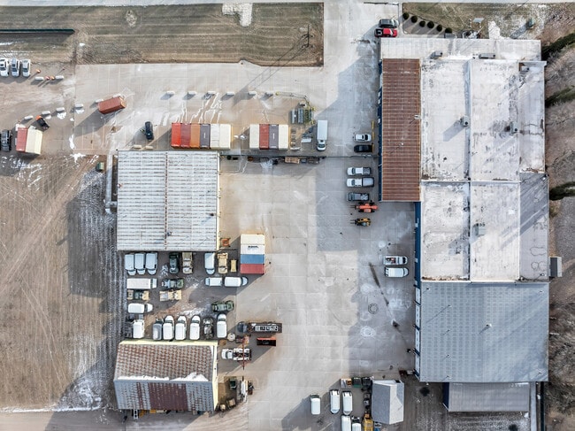
Property Record
3031 Oregon St, Oshkosh, WI 54902
NEARBY LISTINGS FOR SALE OR LEASE
Property Detail
3031 Oregon St
14-13450000
W 400 FT OF E 433 FT OF N 776.2 FT OF S 982.7 FT EXC N 201.2FT OF S 982.7 FT OF W 281 FT OF E 321 FT SE1/4 SEC 35-18-16
Commercialnec
Winnebago
X
Wisconsin
55039C0100F
5.83 AC
2024
Appleton/Oshkosh
2024
Other Market Areas
001500
Oshkosh-Neenah, WI
45,762 SF
DEMOGRAPHICS near 3031 Oregon St
1 Mile
3 Mile
5 Mile
2024 Total Population
2,105
27,813
66,834
2029 Population
2,117
27,930
67,196
Pop Growth 2024-2029
+ 0.57%
+ 0.42%
+ 0.54%
Average Age
42
39
39
2024 Total Households
938
12,585
29,014
HH Growth 2024-2029
+ 0.43%
+ 0.31%
+ 0.67%
Median Household Inc
$68,918
$58,724
$57,339
Avg Household Size
2.20
2.10
2.10
2024 Avg HH Vehicles
2.00
2.00
2.00
Median Home Value
$260,211
$153,913
$165,837
Median Year Built
1964
1958
1971
Nearby Places
Map Layers
Map Styles
 Street
 Aerial
- Restaurants
- Banks
- Shops
- Fitness
- Groceries
PUBLIC TRANSPORTATION
AIRPORT
Appleton International
DRIVE
WALK
Distance
Appleton International
35 min
23.1 mi
SALE & LEASE HISTORY
LISTING DATE
SALE/LEASE

Jul 28, 2025
For Sale
Jan 24, 2019
For Lease
Jan 14, 2025
For Lease
Feb 12, 2019
For Sale
Nearby Properties
Address
Land Use
TOTAL SIZE
Lot Size
Zoning
Address
Land Use
TOTAL SIZE
Lot Size
Zoning
931,304 SF
107 AC
M3
Address
Land Use
TOTAL SIZE
Lot Size
Zoning
7.74 AC
Address
Land Use
TOTAL SIZE
Lot Size
Zoning
570,585 SF
81.26 AC
M2
Address
Land Use
TOTAL SIZE
Lot Size
Zoning
18.38 AC
UIPD
Address
Land Use
TOTAL SIZE
Lot Size
Zoning
128,951 SF
4.95 AC
R1
Address
Land Use
TOTAL SIZE
Lot Size
Zoning
195,847 SF
4.66 AC
UMU-PD
Address
Land Use
TOTAL SIZE
Lot Size
Zoning
2.29 AC
RMUPDRFO
Address
Land Use
TOTAL SIZE
Lot Size
Zoning
110,200 SF
14.77 AC
MR-12-PD
Address
Land Use
TOTAL SIZE
Lot Size
Zoning
70,672 SF
4.97 AC
Address
Land Use
TOTAL SIZE
Lot Size
Zoning
238,238 SF
22.60 AC
M3
Address
Land Use
TOTAL SIZE
Lot Size
Zoning
2.63 AC
RMU-PD-RFO
Address
Land Use
TOTAL SIZE
Lot Size
Zoning
19,488 SF
16.43 AC
C-2
Address
Land Use
TOTAL SIZE
Lot Size
Zoning
136,368 SF
10.24 AC
C-2PD
Address
Land Use
TOTAL SIZE
Lot Size
Zoning
271,088 SF
36.80 AC
M3
Address
Land Use
TOTAL SIZE
Lot Size
Zoning
1.78 AC
C3
Address
Land Use
TOTAL SIZE
Lot Size
Zoning
107,778 SF
8.57 AC
SMUPD
Address
Land Use
TOTAL SIZE
Lot Size
Zoning
117,892 SF
7.36 AC
MR-20
Address
Land Use
TOTAL SIZE
Lot Size
Zoning
9.86 AC
MR-12
Address
Land Use
TOTAL SIZE
Lot Size
Zoning
92,958 SF
1.02 AC
C2
Address
Land Use
TOTAL SIZE
Lot Size
Zoning
128,951 SF
1.15 AC
R1;SINGLE
Address
Land Use
TOTAL SIZE
Lot Size
Zoning
114,338 SF
10.20 AC
C2
Address
Land Use
TOTAL SIZE
Lot Size
Zoning
101,011 SF
16.53 AC
C3
Address
Land Use
TOTAL SIZE
Lot Size
Zoning
58,465 SF
43.67 AC
M3
Address
Land Use
TOTAL SIZE
Lot Size
Zoning
32,430 SF
7.44 AC
M1
Address
Land Use
TOTAL SIZE
Lot Size
Zoning
28,512 SF
6.20 AC
M1
Address
Land Use
TOTAL SIZE
Lot Size
Zoning
100,361 SF
14.25 AC
SMU-PD
Address
Land Use
TOTAL SIZE
Lot Size
Zoning
94,300 SF
1.21 AC
C3
Address
Land Use
TOTAL SIZE
Lot Size
Zoning
91,288 SF
7.29 AC
MR-12
Address
Land Use
TOTAL SIZE
Lot Size
Zoning
88,128 SF
6.33 AC
MR-12
Address
Land Use
TOTAL SIZE
Lot Size
Zoning
42,092 SF
3.21 AC
C2
The World's #1 Commercial Real Estate Marketplace
Connect with us
© 2026 CoStar Group
The information above has been obtained from sources believed reliable. While we do not doubt its accuracy we have not verified it and make no guarantee, warranty or representation about it. It is your responsibility to independently confirm its accuracy and completeness. Any projections, opinions, assumptions, or estimates used are for example only and do not represent the current or future performance of the property. The value of this transaction to you depends on tax and other factors which should be evaluated by your tax, financial, and legal advisors. You and your advisors should conduct a careful, independent investigation of the property to determine to your satisfaction the suitability of the property for your needs.