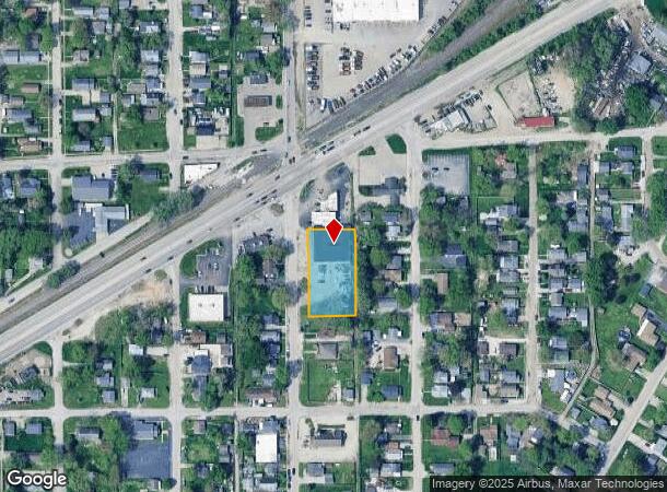
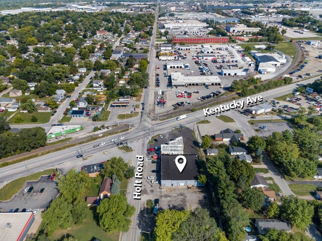
Property Record
3025 S Holt Rd, Indianapolis, IN 46221
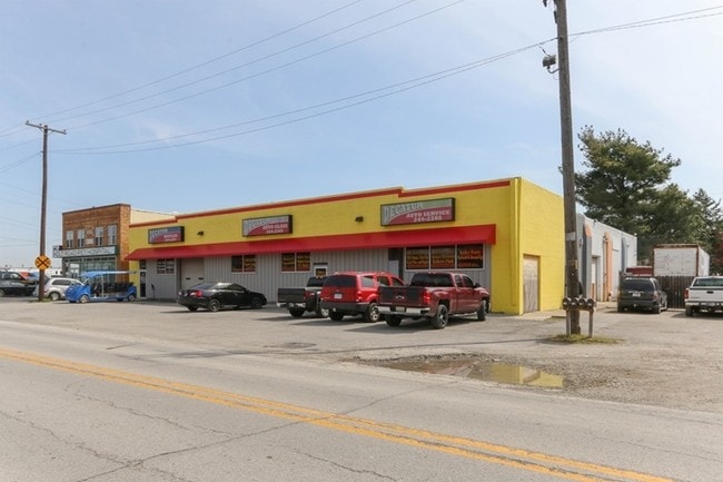
This Property Is For Sale
NEARBY LISTINGS FOR SALE OR LEASE
Property Detail
3025 S Holt Rd
Indianapolis-Carmel-Anderson, IN
Mars Hill
49-11-29-111-575.000-200
MARS HILL L2394 & L2395 & L2396 & L2397 & L2398 &L2399
Commercialnec
Marion
AE
Indiana
18097C0226F
2398
2023
0.12 AC
2024
Stout Field
370204
Indianapolis
11,600 SF
DEMOGRAPHICS near 3025 S Holt Rd
1 Mile
3 Mile
5 Mile
2024 Total Population
7,943
36,980
159,964
2029 Population
7,833
36,610
159,438
Pop Growth 2024-2029
(1.38%)
(1.00%)
(0.33%)
Average Age
36
36
35
2024 Total Households
2,965
13,462
61,727
HH Growth 2024-2029
(1.48%)
(1.12%)
(0.23%)
Median Household Inc
$46,514
$49,833
$54,726
Avg Household Size
2.60
2.70
2.50
2024 Avg HH Vehicles
2.00
2.00
2.00
Median Home Value
$80,761
$91,094
$148,228
Median Year Built
1959
1961
1966
Nearby Places
- Restaurants
- Banks
- Shops
- Fitness
- Groceries
PUBLIC TRANSPORTATION
AIRPORT
Indianapolis International
DRIVE
WALK
Distance
Indianapolis International
17 min
9.9 mi
Nearby Properties
Address
Land Use
TOTAL SIZE
Lot Size
Zoning
Address
Land Use
TOTAL SIZE
Lot Size
Zoning
405,888 SF
19.56 AC
ZO01
Address
Land Use
TOTAL SIZE
Lot Size
Zoning
51,801 SF
0.06 AC
ZO01
Address
Land Use
TOTAL SIZE
Lot Size
Zoning
434,240 SF
26.25 AC
ZO01
Address
Land Use
TOTAL SIZE
Lot Size
Zoning
9,750 SF
43.46 AC
ZO01
Address
Land Use
TOTAL SIZE
Lot Size
Zoning
366,600 SF
29.05 AC
ZO01
Address
Land Use
TOTAL SIZE
Lot Size
Zoning
49,008 SF
4.80 AC
ZO01
Address
Land Use
TOTAL SIZE
Lot Size
Zoning
61,832 SF
0.06 AC
ZO01
Address
Land Use
TOTAL SIZE
Lot Size
Zoning
133,706 SF
83.24 AC
ZO01
Address
Land Use
TOTAL SIZE
Lot Size
Zoning
101,718 SF
49.77 AC
ZO01
Address
Land Use
TOTAL SIZE
Lot Size
Zoning
595,354 SF
193.41 AC
ZO01
Address
Land Use
TOTAL SIZE
Lot Size
Zoning
378,039 SF
0.06 AC
ZO01
Address
Land Use
TOTAL SIZE
Lot Size
Zoning
20,143 SF
17.10 AC
ZO01
Address
Land Use
TOTAL SIZE
Lot Size
Zoning
537,085 SF
111.99 AC
ZO01
Address
Land Use
TOTAL SIZE
Lot Size
Zoning
113,213 SF
0.06 AC
ZO01
Address
Land Use
TOTAL SIZE
Lot Size
Zoning
161,500 SF
9.95 AC
ZO01
Address
Land Use
TOTAL SIZE
Lot Size
Zoning
1,284 SF
25.09 AC
ZO01
Address
Land Use
TOTAL SIZE
Lot Size
Zoning
75,012 SF
0.06 AC
ZO01
Address
Land Use
TOTAL SIZE
Lot Size
Zoning
18,209 SF
38.23 AC
ZO01
Address
Land Use
TOTAL SIZE
Lot Size
Zoning
6,794 SF
5.37 AC
ZO01
Address
Land Use
TOTAL SIZE
Lot Size
Zoning
484,008 SF
17.95 AC
ZO01
Address
Land Use
TOTAL SIZE
Lot Size
Zoning
882,000 SF
194.98 AC
ZO01
Address
Land Use
TOTAL SIZE
Lot Size
Zoning
257,337 SF
0.06 AC
ZO01
Address
Land Use
TOTAL SIZE
Lot Size
Zoning
282,183 SF
23.96 AC
ZO01
Address
Land Use
TOTAL SIZE
Lot Size
Zoning
300,160 SF
17.16 AC
ZO01
Address
Land Use
TOTAL SIZE
Lot Size
Zoning
86,701 SF
8.86 AC
ZO01
Address
Land Use
TOTAL SIZE
Lot Size
Zoning
26,755 SF
2.33 AC
Address
Land Use
TOTAL SIZE
Lot Size
Zoning
112,178 SF
23.51 AC
ZO01
Address
Land Use
TOTAL SIZE
Lot Size
Zoning
221,088 SF
16.69 AC
ZO01
Address
Land Use
TOTAL SIZE
Lot Size
Zoning
120,048 SF
12.82 AC
ZO01
Address
Land Use
TOTAL SIZE
Lot Size
Zoning
12,144 SF
8.65 AC
ZO01
The World's #1 Commercial Real Estate Marketplace
Connect with us
© 2025 CoStar Group
The information above has been obtained from sources believed reliable. While we do not doubt its accuracy we have not verified it and make no guarantee, warranty or representation about it. It is your responsibility to independently confirm its accuracy and completeness. Any projections, opinions, assumptions, or estimates used are for example only and do not represent the current or future performance of the property. The value of this transaction to you depends on tax and other factors which should be evaluated by your tax, financial, and legal advisors. You and your advisors should conduct a careful, independent investigation of the property to determine to your satisfaction the suitability of the property for your needs.