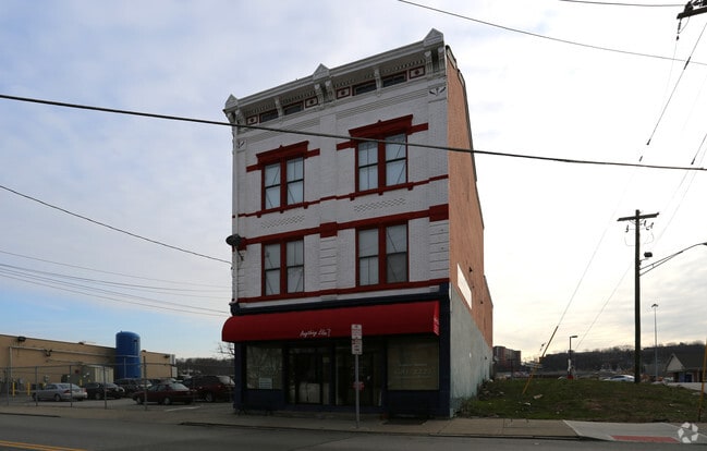
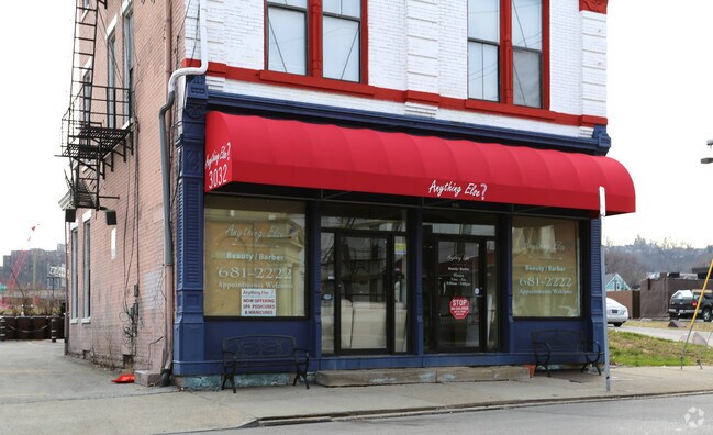
Property Record
3032 Colerain Ave, Cincinnati, OH 45225
NEARBY LISTINGS FOR SALE OR LEASE
Property Detail
3032 Colerain Ave
Cincinnati, OH-KY-IN
Sniveley Sub
189-0023-0139
3032 COLERAIN AVE 40 X 110.95 IRR PT LOT 5 SNIVELEY SUB
Retailwithmorethanonenonretailuse
Hamilton
X
Ohio
39061C0218F
5
2024
0.11 AC
2024
Queensgate
002800
Cincinnati/Dayton
6,424 SF
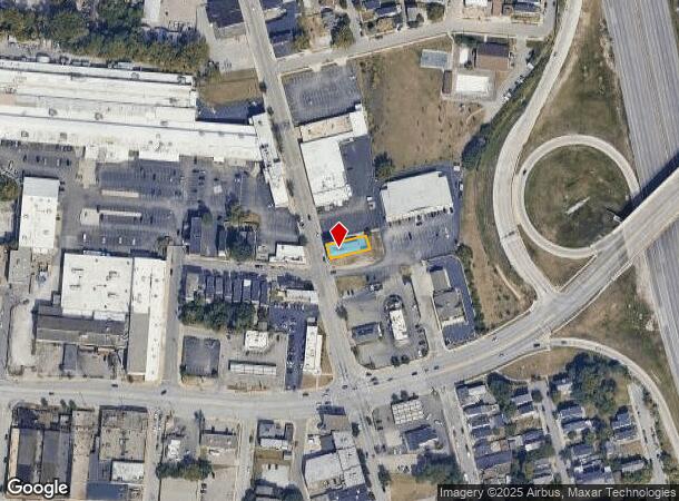
DEMOGRAPHICS near 3032 Colerain Ave
1 Mile
3 Mile
5 Mile
2024 Total Population
16,209
148,708
349,355
2029 Population
16,560
150,652
351,554
Pop Growth 2024-2029
+ 2.17%
+ 1.31%
+ 0.63%
Average Age
33
35
37
2024 Total Households
7,282
65,154
152,808
HH Growth 2024-2029
+ 2.35%
+ 1.38%
+ 0.65%
Median Household Inc
$35,305
$36,633
$45,240
Avg Household Size
1.90
2.00
2.10
2024 Avg HH Vehicles
1.00
1.00
1.00
Median Home Value
$240,228
$186,077
$171,404
Median Year Built
1959
1953
1952
Nearby Places
Map Layers
Map Styles
 Street
 Aerial
- Restaurants
- Banks
- Shops
- Fitness
- Groceries
PUBLIC TRANSPORTATION
COMMUTER RAIL
DRIVE
WALK
Distance
6 min
2.5 mi
AIRPORT
Cincinnati/Northern Kentucky International
DRIVE
WALK
Distance
Cincinnati/Northern Kentucky International
30 min
16.6 mi
SALE & LEASE HISTORY
LISTING DATE
SALE/LEASE

Nov 17, 2019
For Lease
May 23, 2020
For Lease
Nearby Properties
Address
Land Use
TOTAL SIZE
Lot Size
Zoning
Address
Land Use
TOTAL SIZE
Lot Size
Zoning
77.73 AC
IR
Address
Land Use
TOTAL SIZE
Lot Size
Zoning
6.35 AC
IR
Address
Land Use
TOTAL SIZE
Lot Size
Zoning
11.82 AC
Address
Land Use
TOTAL SIZE
Lot Size
Zoning
19.36 AC
Address
Land Use
TOTAL SIZE
Lot Size
Zoning
11.41 AC
IR
Address
Land Use
TOTAL SIZE
Lot Size
Zoning
22.45 AC
Address
Land Use
TOTAL SIZE
Lot Size
Zoning
3.09 AC
Address
Land Use
TOTAL SIZE
Lot Size
Zoning
2.80 AC
IR
Address
Land Use
TOTAL SIZE
Lot Size
Zoning
3.40 AC
IR
Address
Land Use
TOTAL SIZE
Lot Size
Zoning
Address
Land Use
TOTAL SIZE
Lot Size
Zoning
3.51 AC
DD
Address
Land Use
TOTAL SIZE
Lot Size
Zoning
7.14 AC
Address
Land Use
TOTAL SIZE
Lot Size
Zoning
4.46 AC
DD
Address
Land Use
TOTAL SIZE
Lot Size
Zoning
0.91 AC
DD
Address
Land Use
TOTAL SIZE
Lot Size
Zoning
13.32 AC
Address
Land Use
TOTAL SIZE
Lot Size
Zoning
16.67 AC
IR
Address
Land Use
TOTAL SIZE
Lot Size
Zoning
28,160 SF
1 AC
DD
Address
Land Use
TOTAL SIZE
Lot Size
Zoning
9.38 AC
PR
Address
Land Use
TOTAL SIZE
Lot Size
Zoning
1.21 AC
DD
Address
Land Use
TOTAL SIZE
Lot Size
Zoning
2.16 AC
DD
Address
Land Use
TOTAL SIZE
Lot Size
Zoning
12.19 AC
Address
Land Use
TOTAL SIZE
Lot Size
Zoning
10.96 AC
Address
Land Use
TOTAL SIZE
Lot Size
Zoning
3,184 SF
2.34 AC
IR
Address
Land Use
TOTAL SIZE
Lot Size
Zoning
Address
Land Use
TOTAL SIZE
Lot Size
Zoning
Address
Land Use
TOTAL SIZE
Lot Size
Zoning
635,740 SF
1.67 AC
DD
Address
Land Use
TOTAL SIZE
Lot Size
Zoning
0.25 AC
DD
Address
Land Use
TOTAL SIZE
Lot Size
Zoning
29.60 AC
IR
Address
Land Use
TOTAL SIZE
Lot Size
Zoning
3 AC
DD
Address
Land Use
TOTAL SIZE
Lot Size
Zoning
11.36 AC
IR
The World's #1 Commercial Real Estate Marketplace
Connect with us
© 2025 CoStar Group
The information above has been obtained from sources believed reliable. While we do not doubt its accuracy we have not verified it and make no guarantee, warranty or representation about it. It is your responsibility to independently confirm its accuracy and completeness. Any projections, opinions, assumptions, or estimates used are for example only and do not represent the current or future performance of the property. The value of this transaction to you depends on tax and other factors which should be evaluated by your tax, financial, and legal advisors. You and your advisors should conduct a careful, independent investigation of the property to determine to your satisfaction the suitability of the property for your needs.