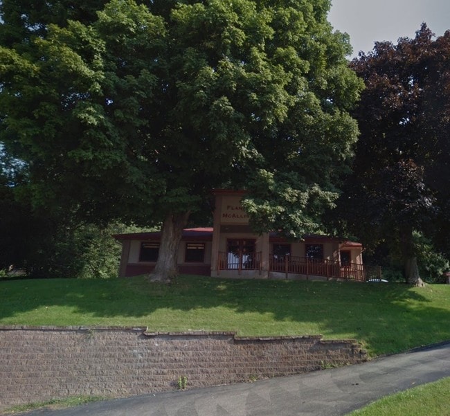
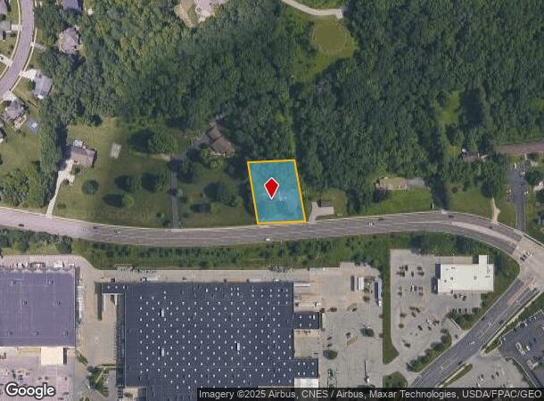
Property Record
3033 E Main St, Onalaska, WI 54650
Property Detail
3033 E Main St
018-003634-003
PRT E1/2-NW COM SE COR NE-NW N 10FT S83D36MW 709.5FT N11D 24MW 33FT TO POB S86D46MW 148.5FT N11D24MW 198FT N86D 46ME 148.5FT S11D24ME 198FT TO POB.
Commercialnec
La Crosse
X
Wisconsin
55063C0170D
0.67 AC
2023
Other Market Areas
2023
La Crosse-Onalaska, WI-MN
010500
NEARBY LISTINGS FOR SALE OR LEASE
DEMOGRAPHICS near 3033 E Main St
1 mile
3 mile
5 mile
2024 Total Population
2,304
20,415
46,964
2029 Population
2,344
20,494
47,370
Pop Growth 2024-2029
+ 1.74%
+ 0.39%
+ 0.86%
Average Age
45
42
41
2024 Total Households
918
8,429
19,955
HH Growth 2024-2029
+ 1.53%
+ 0.21%
+ 0.68%
Median Household Inc
$99,790
$75,584
$63,064
Avg Household Size
2.50
2.40
2.30
2024 Avg HH Vehicles
2.00
2.00
2.00
Median Home Value
$338,000
$254,448
$228,748
Median Year Built
1994
1984
1979
Nearby Places
Map Layers
Map Styles
 Street
 Aerial
Transit
 Traffic
 Biking
Places
Listings with unknown addresses are not visible on the map
- Restaurants
- Banks
- Shops
- Fitness
- Groceries
PUBLIC TRANSPORTATION
COMMUTER RAIL
Drive
Walk
Distance
12 min
6.1 mi
AIRPORT
La Crosse Regional
Drive
Walk
Distance
La Crosse Regional
10 min
6.0 mi
Nearby Properties
Address
Land Use
TOTAL SIZE
Lot Size
Zoning
Address
Land Use
TOTAL SIZE
Lot Size
Zoning
45.53 AC
MZA
Address
Land Use
TOTAL SIZE
Lot Size
Zoning
42.20 AC
MZA
Address
Land Use
TOTAL SIZE
Lot Size
Zoning
6.91 AC
Address
Land Use
TOTAL SIZE
Lot Size
Zoning
7.68 AC
MZA
Address
Land Use
TOTAL SIZE
Lot Size
Zoning
14.59 AC
MZA
Address
Land Use
TOTAL SIZE
Lot Size
Zoning
12,500 SF
5.12 AC
MZA
Address
Land Use
TOTAL SIZE
Lot Size
Zoning
14.61 AC
MZA
Address
Land Use
TOTAL SIZE
Lot Size
Zoning
2.52 AC
Address
Land Use
TOTAL SIZE
Lot Size
Zoning
19.67 AC
MZA
Address
Land Use
TOTAL SIZE
Lot Size
Zoning
15.41 AC
MZA
Address
Land Use
TOTAL SIZE
Lot Size
Zoning
2.63 AC
MZA
Address
Land Use
TOTAL SIZE
Lot Size
Zoning
19.98 AC
Address
Land Use
TOTAL SIZE
Lot Size
Zoning
5.98 AC
MZA
Address
Land Use
TOTAL SIZE
Lot Size
Zoning
4.40 AC
Address
Land Use
TOTAL SIZE
Lot Size
Zoning
33.17 AC
MZA
Address
Land Use
TOTAL SIZE
Lot Size
Zoning
5.90 AC
Address
Land Use
TOTAL SIZE
Lot Size
Zoning
10.64 AC
MZA
Address
Land Use
TOTAL SIZE
Lot Size
Zoning
5.03 AC
Address
Land Use
TOTAL SIZE
Lot Size
Zoning
11.04 AC
MZA
Address
Land Use
TOTAL SIZE
Lot Size
Zoning
8.40 AC
MZA
Address
Land Use
TOTAL SIZE
Lot Size
Zoning
10.92 AC
MZA
Address
Land Use
TOTAL SIZE
Lot Size
Zoning
11.55 AC
Address
Land Use
TOTAL SIZE
Lot Size
Zoning
7.59 AC
MZA
Address
Land Use
TOTAL SIZE
Lot Size
Zoning
8.39 AC
MZA
Address
Land Use
TOTAL SIZE
Lot Size
Zoning
6.90 AC
MZA
Address
Land Use
TOTAL SIZE
Lot Size
Zoning
12.78 AC
Address
Land Use
TOTAL SIZE
Lot Size
Zoning
6 AC
MZA
Address
Land Use
TOTAL SIZE
Lot Size
Zoning
8.39 AC
Address
Land Use
TOTAL SIZE
Lot Size
Zoning
Address
Land Use
TOTAL SIZE
Lot Size
Zoning
The World's #1 Commercial Real Estate Marketplace
Connect with us
© 2026 CoStar Group
The information above has been obtained from sources believed reliable. While we do not doubt its accuracy we have not verified it and make no guarantee, warranty or representation about it. It is your responsibility to independently confirm its accuracy and completeness. Any projections, opinions, assumptions, or estimates used are for example only and do not represent the current or future performance of the property. The value of this transaction to you depends on tax and other factors which should be evaluated by your tax, financial, and legal advisors. You and your advisors should conduct a careful, independent investigation of the property to determine to your satisfaction the suitability of the property for your needs.