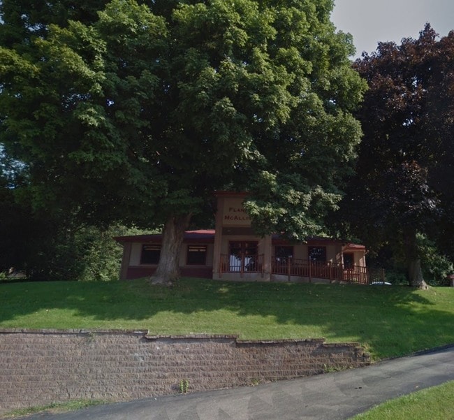
Property Record
3033 E Main St, Onalaska, WI 54650
Save to a Folder
{{folder.Name}}
{{folder.ListingIds.length}} Properties
{{folder.ListingIds.length}} Property
Create a New Folder
Property Detail
3033 E Main St
018-003634-003
PRT E1/2-NW COM SE COR NE-NW N 10FT S83D36MW 709.5FT N11D 24MW 33FT TO POB S86D46MW 148.5FT N11D24MW 198FT N86D 46ME 148.5FT S11D24ME 198FT TO POB.
Commercialnec
La Crosse
MZA
Wisconsin
B and X Area of moderate flood hazard, usually the area between the limits of the 100-year and 500-year floods.
0.67 AC
2025
Other Market Areas
2025
La Crosse-Onalaska, WI-MN
010500
NEARBY LISTINGS FOR SALE OR LEASE
-
-
View all Onalaska listings for sale on LoopNet.com
DEMOGRAPHICS near 3033 E Main St
1 mile
3 mile
5 mile
2025 Total Population
1,975
19,819
44,758
2030 Population
2,001
19,929
44,879
Pop Growth 2025-2030
+ 1.32%
+ 0.56%
+ 0.27%
Average Age
45
42
41
2025 Total Households
794
8,143
18,964
HH Growth 2025-2030
+ 1.13%
+ 0.28%
+ 0.02%
Median Household Inc
$108,969
$87,542
$72,290
Avg Household Size
2.40
2.40
2.30
2025 Avg HH Vehicles
2.00
2.00
2.00
Median Home Value
$370,171
$317,839
$288,519
Median Year Built
1994
1986
1980
Nearby Places
Map Layers
Map Styles
 Street
 Aerial
Layers
 Traffic
 Biking
Places
Listings with unknown addresses are not visible on the map
- Restaurants
- Banks
- Shops
- Fitness
- Groceries
PUBLIC TRANSPORTATION
COMMUTER RAIL
La Crosse (Empire Builder - Amtrak)
Drive
Walk
Distance
La Crosse (Empire Builder - Amtrak)
12 min
6.1 mi
AIRPORT
La Crosse Regional
Drive
Walk
Distance
La Crosse Regional
10 min
6.0 mi
Freight Ports
Port Milwaukee
Drive
Walk
Distance
Port Milwaukee
227 min
205.8 mi
Nearby Properties
Address
Land Use
TOTAL SIZE
Lot Size
Zoning
Address
Land Use
TOTAL SIZE
Lot Size
Zoning
45.53 AC
MZA
Address
Land Use
TOTAL SIZE
Lot Size
Zoning
42.20 AC
MZA
Address
Land Use
TOTAL SIZE
Lot Size
Zoning
7.68 AC
MZA
Address
Land Use
TOTAL SIZE
Lot Size
Zoning
6.91 AC
Address
Land Use
TOTAL SIZE
Lot Size
Zoning
14.59 AC
MZA
Address
Land Use
TOTAL SIZE
Lot Size
Zoning
12,500 SF
5.12 AC
MZA
Address
Land Use
TOTAL SIZE
Lot Size
Zoning
14.61 AC
MZA
Address
Land Use
TOTAL SIZE
Lot Size
Zoning
2.52 AC
Address
Land Use
TOTAL SIZE
Lot Size
Zoning
19.67 AC
MZA
Address
Land Use
TOTAL SIZE
Lot Size
Zoning
15.41 AC
MZA
Address
Land Use
TOTAL SIZE
Lot Size
Zoning
2.63 AC
MZA
Address
Land Use
TOTAL SIZE
Lot Size
Zoning
4.40 AC
Address
Land Use
TOTAL SIZE
Lot Size
Zoning
19.98 AC
Address
Land Use
TOTAL SIZE
Lot Size
Zoning
5.98 AC
MZA
Address
Land Use
TOTAL SIZE
Lot Size
Zoning
5.03 AC
Address
Land Use
TOTAL SIZE
Lot Size
Zoning
10.92 AC
MZA
Address
Land Use
TOTAL SIZE
Lot Size
Zoning
4.27 AC
Address
Land Use
TOTAL SIZE
Lot Size
Zoning
11.04 AC
MZA
Address
Land Use
TOTAL SIZE
Lot Size
Zoning
11.55 AC
Address
Land Use
TOTAL SIZE
Lot Size
Zoning
8.39 AC
MZA
Address
Land Use
TOTAL SIZE
Lot Size
Zoning
8.40 AC
MZA
Address
Land Use
TOTAL SIZE
Lot Size
Zoning
Address
Land Use
TOTAL SIZE
Lot Size
Zoning
6.90 AC
MZA
Address
Land Use
TOTAL SIZE
Lot Size
Zoning
7.59 AC
MZA
Address
Land Use
TOTAL SIZE
Lot Size
Zoning
8.39 AC
Address
Land Use
TOTAL SIZE
Lot Size
Zoning
12.78 AC
Address
Land Use
TOTAL SIZE
Lot Size
Zoning
33.88 AC
MZA
Address
Land Use
TOTAL SIZE
Lot Size
Zoning
4.64 AC
MZA
Address
Land Use
TOTAL SIZE
Lot Size
Zoning
15.01 AC
MZA
Address
Land Use
TOTAL SIZE
Lot Size
Zoning
12.61 AC
The World's #1 Commercial Real Estate Marketplace
Connect with us
© 2026 CoStar Group
The information above has been obtained from sources believed reliable. While we do not doubt its accuracy we have not verified it and make no guarantee, warranty or representation about it. It is your responsibility to independently confirm its accuracy and completeness. Any projections, opinions, assumptions, or estimates used are for example only and do not represent the current or future performance of the property. The value of this transaction to you depends on tax and other factors which should be evaluated by your tax, financial, and legal advisors. You and your advisors should conduct a careful, independent investigation of the property to determine to your satisfaction the suitability of the property for your needs.