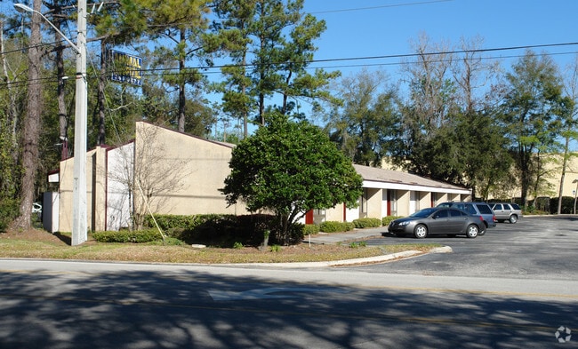
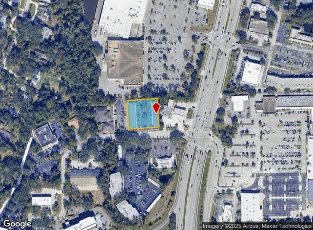
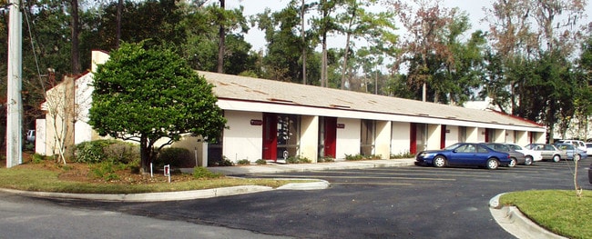
Property Record
3033 Hartley Rd, Jacksonville, FL 32257

Current Lease Availabilities
NEARBY LISTINGS FOR SALE OR LEASE
Property Detail
3033 Hartley Rd
Jacksonville, FL
Section Land
155922-0030
06-4S-27E .87 PT GOVT LOT 2 RECD O/R 11578-2061
Officebuilding
Duval
X
Florida
12031C0542J
2
2024
0.88 AC
2025
Mandarin
016711
Jacksonville (Florida)
10,816 SF
DEMOGRAPHICS near 3033 Hartley Rd
1 Mile
3 Mile
5 Mile
2024 Total Population
7,027
57,239
124,568
2029 Population
7,262
59,531
132,031
Pop Growth 2024-2029
+ 3.34%
+ 4.00%
+ 5.99%
Average Age
42
42
41
2024 Total Households
2,935
23,451
50,830
HH Growth 2024-2029
+ 3.44%
+ 4.04%
+ 5.92%
Median Household Inc
$79,469
$77,138
$72,129
Avg Household Size
2.40
2.40
2.30
2024 Avg HH Vehicles
2.00
2.00
2.00
Median Home Value
$279,517
$285,643
$295,285
Median Year Built
1980
1985
1986
Nearby Places
- Restaurants
- Banks
- Shops
- Fitness
- Groceries
PUBLIC TRANSPORTATION
AIRPORT
Jacksonville International
DRIVE
WALK
Distance
Jacksonville International
45 min
32.9 mi
Freight Ports
Jacksonville Port
DRIVE
WALK
Distance
Jacksonville Port
30 min
15.7 mi
Nearby Properties
Address
Land Use
TOTAL SIZE
Lot Size
Zoning
Address
Land Use
TOTAL SIZE
Lot Size
Zoning
438,185 SF
35.14 AC
RMD-D
Address
Land Use
TOTAL SIZE
Lot Size
Zoning
287,406 SF
32.10 AC
CCG-1
Address
Land Use
TOTAL SIZE
Lot Size
Zoning
193,858 SF
8.67 AC
PUD
Address
Land Use
TOTAL SIZE
Lot Size
Zoning
266,087 SF
35.07 AC
RMD-D
Address
Land Use
TOTAL SIZE
Lot Size
Zoning
304,017 SF
20.58 AC
RMD-D
Address
Land Use
TOTAL SIZE
Lot Size
Zoning
291,833 SF
16.91 AC
CRO
Address
Land Use
TOTAL SIZE
Lot Size
Zoning
236,068 SF
18.87 AC
PUD
Address
Land Use
TOTAL SIZE
Lot Size
Zoning
404,315 SF
19.27 AC
RMD-D
Address
Land Use
TOTAL SIZE
Lot Size
Zoning
294,353 SF
14.58 AC
RMD-D
Address
Land Use
TOTAL SIZE
Lot Size
Zoning
327,854 SF
26.24 AC
RMD-D
Address
Land Use
TOTAL SIZE
Lot Size
Zoning
207,736 SF
18.55 AC
RMD-C
Address
Land Use
TOTAL SIZE
Lot Size
Zoning
240,240 SF
13.91 AC
PUD
Address
Land Use
TOTAL SIZE
Lot Size
Zoning
166,126 SF
17.26 AC
CCG-1
Address
Land Use
TOTAL SIZE
Lot Size
Zoning
148,931 SF
16.93 AC
RMD-D
Address
Land Use
TOTAL SIZE
Lot Size
Zoning
273,060 SF
23.70 AC
CCG-1
Address
Land Use
TOTAL SIZE
Lot Size
Zoning
248,748 SF
17.60 AC
RMD-D
Address
Land Use
TOTAL SIZE
Lot Size
Zoning
96,065 SF
4.11 AC
PUD
Address
Land Use
TOTAL SIZE
Lot Size
Zoning
213,374 SF
14.77 AC
PUD
Address
Land Use
TOTAL SIZE
Lot Size
Zoning
177,088 SF
15.02 AC
RMD-D
Address
Land Use
TOTAL SIZE
Lot Size
Zoning
167,580 SF
13.16 AC
RMD-D
Address
Land Use
TOTAL SIZE
Lot Size
Zoning
246,534 SF
18.99 AC
RMD-D
Address
Land Use
TOTAL SIZE
Lot Size
Zoning
263,796 SF
36.89 AC
PUD
Address
Land Use
TOTAL SIZE
Lot Size
Zoning
388,745 SF
49.78 AC
PBF-1
Address
Land Use
TOTAL SIZE
Lot Size
Zoning
128,770 SF
8.74 AC
RMD-C
Address
Land Use
TOTAL SIZE
Lot Size
Zoning
150,805 SF
26.53 AC
CRO
Address
Land Use
TOTAL SIZE
Lot Size
Zoning
114,215 SF
14.08 AC
PUD
Address
Land Use
TOTAL SIZE
Lot Size
Zoning
217,560 SF
17.08 AC
CCG-1
Address
Land Use
TOTAL SIZE
Lot Size
Zoning
80,974 SF
4.94 AC
CCG-1
Address
Land Use
TOTAL SIZE
Lot Size
Zoning
113,046 SF
10.29 AC
RMD-D
Address
Land Use
TOTAL SIZE
Lot Size
Zoning
80,366 SF
10.80 AC
RMD-D
The World's #1 Commercial Real Estate Marketplace
Connect with us
© 2025 CoStar Group
The information above has been obtained from sources believed reliable. While we do not doubt its accuracy we have not verified it and make no guarantee, warranty or representation about it. It is your responsibility to independently confirm its accuracy and completeness. Any projections, opinions, assumptions, or estimates used are for example only and do not represent the current or future performance of the property. The value of this transaction to you depends on tax and other factors which should be evaluated by your tax, financial, and legal advisors. You and your advisors should conduct a careful, independent investigation of the property to determine to your satisfaction the suitability of the property for your needs.