Property Record
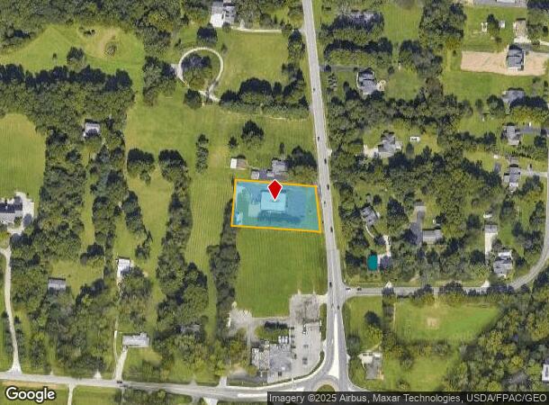
3033 Rey New Albany Rd, New Albany, OH 43054
NEARBY LISTINGS FOR SALE OR LEASE
Property Detail
3033 Rey New Albany Rd
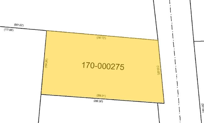
170-000275
William Headley Partition
Medicalbuilding
3033 REYN NEW ALBANY RD R16 T1 1/4T1 1.00 ACRE
X
Franklin
39049C0216K
Ohio
2024
1 AC
2024
East
007306
Columbus
4,800 SF
Columbus, OH
DEMOGRAPHICS near 3033 Rey New Albany Rd
1 Mile
3 Mile
5 Mile
2024 Total Population
3,503
39,305
138,036
2029 Population
3,552
39,443
138,517
Pop Growth 2024-2029
+ 1.40%
+ 0.35%
+ 0.35%
Average Age
41
39
38
2024 Total Households
1,193
15,256
55,831
HH Growth 2024-2029
+ 1.34%
+ 0.20%
+ 0.26%
Median Household Inc
$181,386
$113,564
$93,792
Avg Household Size
2.90
2.50
2.40
2024 Avg HH Vehicles
2.00
2.00
2.00
Median Home Value
$470,821
$362,683
$282,827
Median Year Built
2000
2002
1999
Nearby Places
Map Layers
Map Styles
 Street
 Aerial
- Restaurants
- Banks
- Shops
- Fitness
- Groceries
PUBLIC TRANSPORTATION
AIRPORT
John Glenn Columbus International
DRIVE
WALK
Distance
John Glenn Columbus International
15 min
7.9 mi
Rickenbacker International
DRIVE
WALK
Distance
Rickenbacker International
30 min
19.9 mi
Freight Ports
Port of Toledo
DRIVE
WALK
Distance
Port of Toledo
183 min
147.0 mi
Nearby Properties
Address
Land Use
TOTAL SIZE
Lot Size
Zoning
Address
Land Use
TOTAL SIZE
Lot Size
Zoning
141,988 SF
219.25 AC
Address
Land Use
TOTAL SIZE
Lot Size
Zoning
696,736 SF
76.73 AC
Address
Land Use
TOTAL SIZE
Lot Size
Zoning
672,706 SF
222.09 AC
Address
Land Use
TOTAL SIZE
Lot Size
Zoning
260,944 SF
17.30 AC
Address
Land Use
TOTAL SIZE
Lot Size
Zoning
80,007 SF
27.54 AC
Address
Land Use
TOTAL SIZE
Lot Size
Zoning
204,829 SF
37.69 AC
Address
Land Use
TOTAL SIZE
Lot Size
Zoning
94,416 SF
13.95 AC
Address
Land Use
TOTAL SIZE
Lot Size
Zoning
71,592 SF
32.42 AC
Address
Land Use
TOTAL SIZE
Lot Size
Zoning
181,819 SF
7.18 AC
Address
Land Use
TOTAL SIZE
Lot Size
Zoning
177,703 SF
21.35 AC
Address
Land Use
TOTAL SIZE
Lot Size
Zoning
173,727 SF
38.26 AC
Address
Land Use
TOTAL SIZE
Lot Size
Zoning
182,892 SF
10.19 AC
Address
Land Use
TOTAL SIZE
Lot Size
Zoning
66,759 SF
8.39 AC
Address
Land Use
TOTAL SIZE
Lot Size
Zoning
115,134 SF
19.79 AC
Address
Land Use
TOTAL SIZE
Lot Size
Zoning
137,441 SF
15.58 AC
Address
Land Use
TOTAL SIZE
Lot Size
Zoning
54,526 SF
1.41 AC
Address
Land Use
TOTAL SIZE
Lot Size
Zoning
95,989 SF
2.81 AC
Address
Land Use
TOTAL SIZE
Lot Size
Zoning
69,514 SF
118.84 AC
Address
Land Use
TOTAL SIZE
Lot Size
Zoning
95,576 SF
16 AC
Address
Land Use
TOTAL SIZE
Lot Size
Zoning
56,961 SF
4.98 AC
Address
Land Use
TOTAL SIZE
Lot Size
Zoning
211,187 SF
32.06 AC
Address
Land Use
TOTAL SIZE
Lot Size
Zoning
102,652 SF
11.71 AC
Address
Land Use
TOTAL SIZE
Lot Size
Zoning
62,233 SF
17.17 AC
Address
Land Use
TOTAL SIZE
Lot Size
Zoning
50,839 SF
17.18 AC
Address
Land Use
TOTAL SIZE
Lot Size
Zoning
31,944 SF
1.41 AC
Address
Land Use
TOTAL SIZE
Lot Size
Zoning
75,265 SF
1.72 AC
Address
Land Use
TOTAL SIZE
Lot Size
Zoning
38,636 SF
8.66 AC
Address
Land Use
TOTAL SIZE
Lot Size
Zoning
107,757 SF
4.21 AC
Address
Land Use
TOTAL SIZE
Lot Size
Zoning
96,938 SF
14.15 AC
Address
Land Use
TOTAL SIZE
Lot Size
Zoning
49,726 SF
5.07 AC
The World's #1 Commercial Real Estate Marketplace
Connect with us
© 2025 CoStar Group
The information above has been obtained from sources believed reliable. While we do not doubt its accuracy we have not verified it and make no guarantee, warranty or representation about it. It is your responsibility to independently confirm its accuracy and completeness. Any projections, opinions, assumptions, or estimates used are for example only and do not represent the current or future performance of the property. The value of this transaction to you depends on tax and other factors which should be evaluated by your tax, financial, and legal advisors. You and your advisors should conduct a careful, independent investigation of the property to determine to your satisfaction the suitability of the property for your needs.