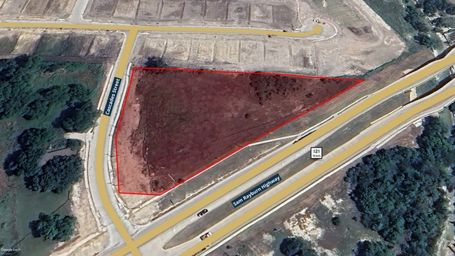
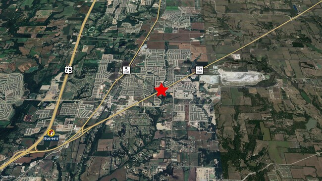
Property Record
3030 Sam Rayburn Hwy, Melissa, TX 75454

Property Detail
3030 Sam Rayburn Hwy
Dallas/Ft Worth
ORENDUFF ADDITION, BLK A, LOT 2
Dallas-Fort Worth-Arlington, TX
COLLIN
R-13085-00A-0020-1
Texas
Residentialacreage
2
2025
2.53 AC
2025
Outlying Collin County
030207
NEARBY LISTINGS FOR SALE OR LEASE
DEMOGRAPHICS near 3030 Sam Rayburn Hwy
1 mile
3 mile
5 mile
2025 Total Population
10,051
32,197
62,971
2030 Population
11,944
38,261
75,053
Pop Growth 2025-2030
+ 18.83%
+ 18.83%
+ 19.19%
Average Age
36
36
37
2025 Total Households
3,083
10,176
20,278
HH Growth 2025-2030
+ 19.10%
+ 19.12%
+ 19.48%
Median Household Inc
$131,287
$135,944
$127,765
Avg Household Size
3.20
3.20
3.10
2025 Avg HH Vehicles
2.00
2.00
2.00
Median Home Value
$572,464
$527,227
$482,729
Median Year Built
2011
2011
2011
Nearby Places
Map Layers
Map Styles
 Street
 Aerial
Transit
 Traffic
 Biking
Places
Listings with unknown addresses are not visible on the map
- Restaurants
- Banks
- Shops
- Fitness
- Groceries
SALE & LEASE HISTORY
LISTING DATE
SALE/LEASE

Jul 15, 2024
For Sale
Nearby Properties
Address
Land Use
TOTAL SIZE
Lot Size
Zoning
Address
Land Use
TOTAL SIZE
Lot Size
Zoning
244,746 SF
34.90 AC
Address
Land Use
TOTAL SIZE
Lot Size
Zoning
334,535 SF
75.25 AC
Address
Land Use
TOTAL SIZE
Lot Size
Zoning
428,778 SF
15.87 AC
Address
Land Use
TOTAL SIZE
Lot Size
Zoning
428,537 SF
19.95 AC
PD
Address
Land Use
TOTAL SIZE
Lot Size
Zoning
372,239 SF
18.42 AC
Address
Land Use
TOTAL SIZE
Lot Size
Zoning
226,096 SF
51.58 AC
Address
Land Use
TOTAL SIZE
Lot Size
Zoning
298,586 SF
13.37 AC
PD
Address
Land Use
TOTAL SIZE
Lot Size
Zoning
322,580 SF
12.40 AC
Address
Land Use
TOTAL SIZE
Lot Size
Zoning
241,750 SF
18.95 AC
Address
Land Use
TOTAL SIZE
Lot Size
Zoning
204,764 SF
19.65 AC
PD
Address
Land Use
TOTAL SIZE
Lot Size
Zoning
163,398 SF
39.25 AC
Address
Land Use
TOTAL SIZE
Lot Size
Zoning
285,566 SF
8.26 AC
PD
Address
Land Use
TOTAL SIZE
Lot Size
Zoning
219,188 SF
3.35 AC
AG
Address
Land Use
TOTAL SIZE
Lot Size
Zoning
79,881 SF
9.86 AC
PD
Address
Land Use
TOTAL SIZE
Lot Size
Zoning
117,600 SF
3.88 AC
Address
Land Use
TOTAL SIZE
Lot Size
Zoning
169,777 SF
36.25 AC
Address
Land Use
TOTAL SIZE
Lot Size
Zoning
201,496 SF
9.93 AC
PD
Address
Land Use
TOTAL SIZE
Lot Size
Zoning
124,662 SF
11.52 AC
PD
Address
Land Use
TOTAL SIZE
Lot Size
Zoning
36,135 SF
3.68 AC
Address
Land Use
TOTAL SIZE
Lot Size
Zoning
81,220 SF
11.57 AC
EX
Address
Land Use
TOTAL SIZE
Lot Size
Zoning
53,292 SF
12.22 AC
Address
Land Use
TOTAL SIZE
Lot Size
Zoning
86,757 SF
12 AC
Address
Land Use
TOTAL SIZE
Lot Size
Zoning
103,884 SF
8.31 AC
Address
Land Use
TOTAL SIZE
Lot Size
Zoning
78,410 SF
19.57 AC
Address
Land Use
TOTAL SIZE
Lot Size
Zoning
32,076 SF
4.20 AC
Address
Land Use
TOTAL SIZE
Lot Size
Zoning
64,731 SF
6.53 AC
AG
Address
Land Use
TOTAL SIZE
Lot Size
Zoning
786,776 SF
53.27 AC
Address
Land Use
TOTAL SIZE
Lot Size
Zoning
84,055 SF
81.98 AC
COMM
Address
Land Use
TOTAL SIZE
Lot Size
Zoning
40,652 SF
9.42 AC
Address
Land Use
TOTAL SIZE
Lot Size
Zoning
193,645 SF
9.48 AC
MF-L
The World's #1 Commercial Real Estate Marketplace
Connect with us
© 2026 CoStar Group
The information above has been obtained from sources believed reliable. While we do not doubt its accuracy we have not verified it and make no guarantee, warranty or representation about it. It is your responsibility to independently confirm its accuracy and completeness. Any projections, opinions, assumptions, or estimates used are for example only and do not represent the current or future performance of the property. The value of this transaction to you depends on tax and other factors which should be evaluated by your tax, financial, and legal advisors. You and your advisors should conduct a careful, independent investigation of the property to determine to your satisfaction the suitability of the property for your needs.