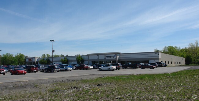
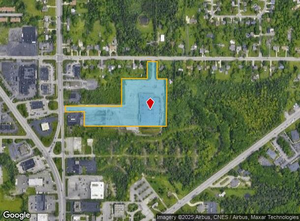
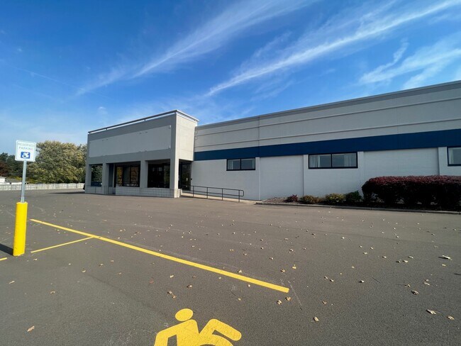
Property Record
3035 Union Rd, Orchard Park, NY 14127
Current Lease Availabilities
NEARBY LISTINGS FOR SALE OR LEASE
Property Detail
3035 Union Rd
146089-152-120-0004-004-000
Buffalo Crk Reservation
Commercialofficeresidentialmixeduse
Erie
X
New York
36029C0361H
4.000
2025
9.65 AC
2024
South
013702
Buffalo/Niagara Falls
85,986 SF
Buffalo-Cheektowaga, NY
DEMOGRAPHICS near 3035 Union Rd
1 Mile
3 Mile
5 Mile
2024 Total Population
6,788
48,133
136,684
2029 Population
6,769
48,030
135,466
Pop Growth 2024-2029
(0.28%)
(0.21%)
(0.89%)
Average Age
46
44
43
2024 Total Households
3,051
20,738
59,277
HH Growth 2024-2029
(0.33%)
(0.25%)
(0.95%)
Median Household Inc
$68,420
$77,002
$68,747
Avg Household Size
2.20
2.30
2.20
2024 Avg HH Vehicles
2.00
2.00
2.00
Median Home Value
$226,180
$221,094
$193,420
Median Year Built
1973
1969
1962
Nearby Places
Map Layers
Map Styles
 Street
 Aerial
- Restaurants
- Banks
- Shops
- Fitness
- Groceries
PUBLIC TRANSPORTATION
COMMUTER RAIL
DRIVE
WALK
Distance
18 min
8.8 mi
DRIVE
WALK
Distance
19 min
9.2 mi
AIRPORT
Buffalo Niagara International
DRIVE
WALK
Distance
Buffalo Niagara International
25 min
12.0 mi
Niagara Falls International
DRIVE
WALK
Distance
Niagara Falls International
46 min
29.4 mi
Nearby Properties
Address
Land Use
TOTAL SIZE
Lot Size
Zoning
Address
Land Use
TOTAL SIZE
Lot Size
Zoning
49,500 SF
108.40 AC
R1
Address
Land Use
TOTAL SIZE
Lot Size
Zoning
13,152 SF
496 AC
08 - GOVER
Address
Land Use
TOTAL SIZE
Lot Size
Zoning
183,334 SF
50.90 AC
B2
Address
Land Use
TOTAL SIZE
Lot Size
Zoning
197,584 SF
32.50 AC
B2
Address
Land Use
TOTAL SIZE
Lot Size
Zoning
124,112 SF
53.10 AC
05 - COMME
Address
Land Use
TOTAL SIZE
Lot Size
Zoning
149,065 SF
21.53 AC
B2
Address
Land Use
TOTAL SIZE
Lot Size
Zoning
205,680 SF
37.40 AC
11
Address
Land Use
TOTAL SIZE
Lot Size
Zoning
145,881 SF
29.40 AC
10
Address
Land Use
TOTAL SIZE
Lot Size
Zoning
202,597 SF
24.22 AC
Address
Land Use
TOTAL SIZE
Lot Size
Zoning
191,026 SF
32.60 AC
10
Address
Land Use
TOTAL SIZE
Lot Size
Zoning
34,968 SF
18.26 AC
10
Address
Land Use
TOTAL SIZE
Lot Size
Zoning
8,320 SF
22.10 AC
Address
Land Use
TOTAL SIZE
Lot Size
Zoning
13,062 SF
26.07 AC
R4
Address
Land Use
TOTAL SIZE
Lot Size
Zoning
235,940 SF
62.47 AC
R2
Address
Land Use
TOTAL SIZE
Lot Size
Zoning
3,361 SF
28.04 AC
R3
Address
Land Use
TOTAL SIZE
Lot Size
Zoning
143,400 SF
11.33 AC
B1
Address
Land Use
TOTAL SIZE
Lot Size
Zoning
98,938 SF
25.60 AC
06 - INDUS
Address
Land Use
TOTAL SIZE
Lot Size
Zoning
161,077 SF
31 AC
10
Address
Land Use
TOTAL SIZE
Lot Size
Zoning
87,835 SF
21.86 AC
Address
Land Use
TOTAL SIZE
Lot Size
Zoning
134,680 SF
16.47 AC
B2
Address
Land Use
TOTAL SIZE
Lot Size
Zoning
53,511 SF
5.01 AC
B1
Address
Land Use
TOTAL SIZE
Lot Size
Zoning
82,954 SF
25.50 AC
Address
Land Use
TOTAL SIZE
Lot Size
Zoning
Address
Land Use
TOTAL SIZE
Lot Size
Zoning
Address
Land Use
TOTAL SIZE
Lot Size
Zoning
284,403 SF
27.29 AC
I1
Address
Land Use
TOTAL SIZE
Lot Size
Zoning
9,322 SF
4.70 AC
B2
Address
Land Use
TOTAL SIZE
Lot Size
Zoning
9,224 SF
19.25 AC
01 - NOT Z
Address
Land Use
TOTAL SIZE
Lot Size
Zoning
Address
Land Use
TOTAL SIZE
Lot Size
Zoning
118,891 SF
8.99 AC
I1
Address
Land Use
TOTAL SIZE
Lot Size
Zoning
64,283 SF
18.67 AC
10
The World's #1 Commercial Real Estate Marketplace
Connect with us
© 2026 CoStar Group
The information above has been obtained from sources believed reliable. While we do not doubt its accuracy we have not verified it and make no guarantee, warranty or representation about it. It is your responsibility to independently confirm its accuracy and completeness. Any projections, opinions, assumptions, or estimates used are for example only and do not represent the current or future performance of the property. The value of this transaction to you depends on tax and other factors which should be evaluated by your tax, financial, and legal advisors. You and your advisors should conduct a careful, independent investigation of the property to determine to your satisfaction the suitability of the property for your needs.