Property Record
3035 W Highway 290, Dripping Springs, TX 78620
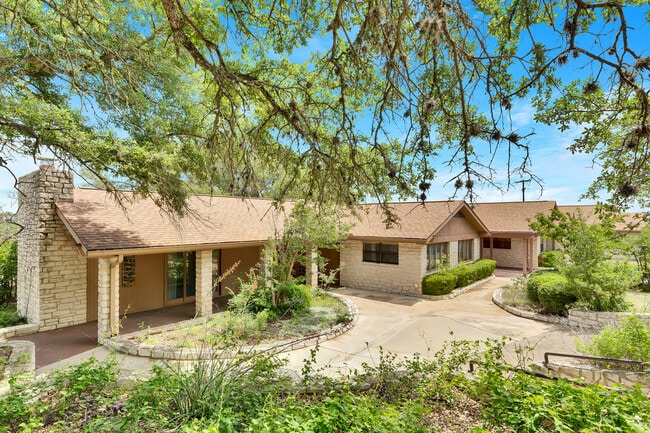
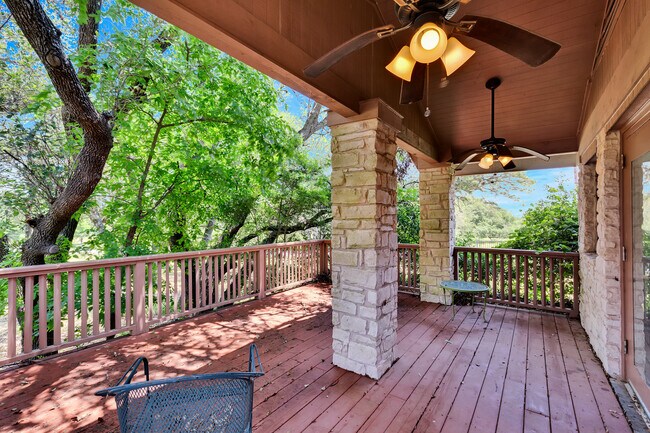
This Property Is For Sale
Property Detail
3035 W Highway 290
R15111
A0222 BENJAMIN F HANNA SURVEY, ACRES 4.039
Commercialnec
Hays
B and X Area of moderate flood hazard, usually the area between the limits of the 100-year and 500-year floods.
Texas
2024
2.97 AC
2025
Hays County
010807
Austin
13,622 SF
Austin-Round Rock-San Marcos, TX
NEARBY LISTINGS FOR SALE OR LEASE
DEMOGRAPHICS near 3035 W Highway 290
1 mile
3 mile
5 mile
2025 Total Population
1,452
6,909
14,464
2030 Population
1,730
8,127
17,025
Pop Growth 2025-2030
+ 19.15%
+ 17.63%
+ 17.71%
Average Age
42
42
42
2025 Total Households
520
2,509
5,279
HH Growth 2025-2030
+ 20.19%
+ 18.65%
+ 18.72%
Median Household Inc
$136,250
$127,073
$135,311
Avg Household Size
2.80
2.70
2.70
2025 Avg HH Vehicles
3.00
2.00
2.00
Median Home Value
$851,351
$805,068
$805,614
Median Year Built
2010
2007
2009
Nearby Places
Map Layers
Map Styles
 Street
 Aerial
Transit
 Traffic
 Biking
Places
Listings with unknown addresses are not visible on the map
- Restaurants
- Banks
- Shops
- Fitness
- Groceries
PUBLIC TRANSPORTATION
AIRPORT
Austin-Bergstrom International
Drive
Walk
Distance
Austin-Bergstrom International
51 min
32.8 mi
Freight Ports
Calhoun Port
Drive
Walk
Distance
Calhoun Port
212 min
171.0 mi
Nearby Properties
Address
Land Use
TOTAL SIZE
Lot Size
Zoning
Address
Land Use
TOTAL SIZE
Lot Size
Zoning
16,274 SF
22.16 AC
Address
Land Use
TOTAL SIZE
Lot Size
Zoning
79,769 SF
35.70 AC
Address
Land Use
TOTAL SIZE
Lot Size
Zoning
38.01 AC
Address
Land Use
TOTAL SIZE
Lot Size
Zoning
Address
Land Use
TOTAL SIZE
Lot Size
Zoning
70,096 SF
6.82 AC
Address
Land Use
TOTAL SIZE
Lot Size
Zoning
27,828 SF
2.18 AC
Address
Land Use
TOTAL SIZE
Lot Size
Zoning
Address
Land Use
TOTAL SIZE
Lot Size
Zoning
16,500 SF
10 AC
Address
Land Use
TOTAL SIZE
Lot Size
Zoning
888 SF
5.93 AC
Address
Land Use
TOTAL SIZE
Lot Size
Zoning
106,783 SF
5.79 AC
Address
Land Use
TOTAL SIZE
Lot Size
Zoning
13,064 SF
3.02 AC
Address
Land Use
TOTAL SIZE
Lot Size
Zoning
24,336 SF
2.72 AC
Address
Land Use
TOTAL SIZE
Lot Size
Zoning
Address
Land Use
TOTAL SIZE
Lot Size
Zoning
13,890 SF
1.05 AC
Address
Land Use
TOTAL SIZE
Lot Size
Zoning
9,913 SF
15.01 AC
Address
Land Use
TOTAL SIZE
Lot Size
Zoning
6,298 SF
4.16 AC
Address
Land Use
TOTAL SIZE
Lot Size
Zoning
14,176 SF
2.34 AC
Address
Land Use
TOTAL SIZE
Lot Size
Zoning
10,824 SF
3.24 AC
Address
Land Use
TOTAL SIZE
Lot Size
Zoning
Address
Land Use
TOTAL SIZE
Lot Size
Zoning
60,980 SF
36.80 AC
Address
Land Use
TOTAL SIZE
Lot Size
Zoning
18,900 SF
3.93 AC
Address
Land Use
TOTAL SIZE
Lot Size
Zoning
196.48 AC
Address
Land Use
TOTAL SIZE
Lot Size
Zoning
Address
Land Use
TOTAL SIZE
Lot Size
Zoning
5.72 AC
Address
Land Use
TOTAL SIZE
Lot Size
Zoning
11,656 SF
2.12 AC
Address
Land Use
TOTAL SIZE
Lot Size
Zoning
46,040 SF
7.56 AC
Address
Land Use
TOTAL SIZE
Lot Size
Zoning
9,869 SF
1.27 AC
Address
Land Use
TOTAL SIZE
Lot Size
Zoning
7,334 SF
2.94 AC
Address
Land Use
TOTAL SIZE
Lot Size
Zoning
953 SF
60.62 AC
Address
Land Use
TOTAL SIZE
Lot Size
Zoning
24,328 SF
5 AC
The World's #1 Commercial Real Estate Marketplace
Connect with us
© 2026 CoStar Group
The information above has been obtained from sources believed reliable. While we do not doubt its accuracy we have not verified it and make no guarantee, warranty or representation about it. It is your responsibility to independently confirm its accuracy and completeness. Any projections, opinions, assumptions, or estimates used are for example only and do not represent the current or future performance of the property. The value of this transaction to you depends on tax and other factors which should be evaluated by your tax, financial, and legal advisors. You and your advisors should conduct a careful, independent investigation of the property to determine to your satisfaction the suitability of the property for your needs.